
LankaTrip Insights

27 min read

Adam's Peak Climbing Season 2026 and 2027: The Full Pilgrimage Calendar, and the Access Problem Nobody Has Written About

The 2026 to 2027 Sri Pada season opens on Unduvap Poya in late December. But Hatton station, the arrival point for almost every visitor climbing Adam's Peak, sits on the closed section of the main line and is not expected to reopen until around January 2027.

Back to blog
Adam's Peak Climbing Season 2026 and 2027: The Full Pilgrimage Calendar, and the Access Problem Nobody Has Written About

Adam's Peak is one of the few places in the world venerated by four religions at once, and one of the few mountains anywhere that has a formal opening and closing date.

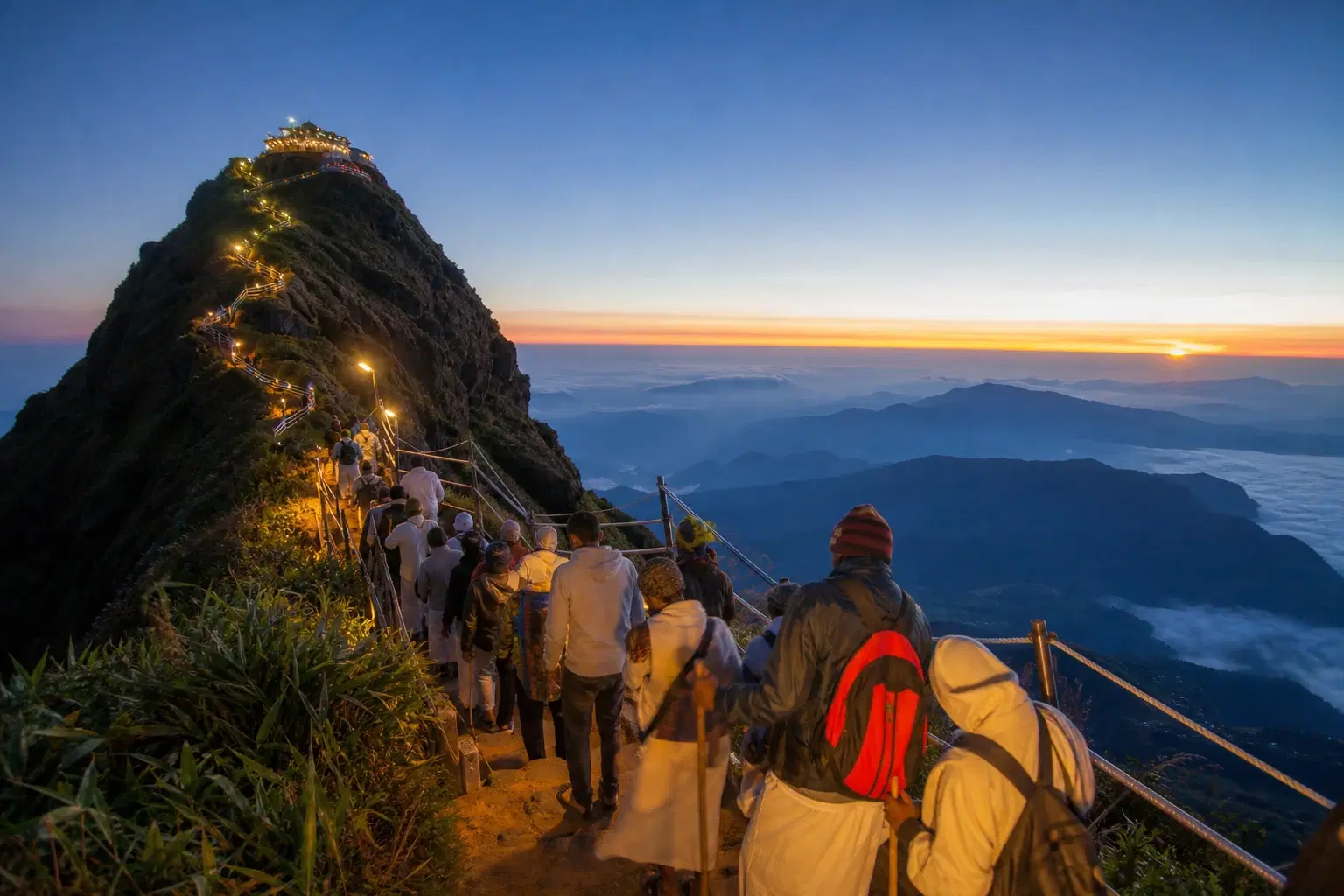
For six months the mountain functions as a piece of national infrastructure. The steps are lit through the night, tea shops open at intervals the whole way up, first aid points operate, police are on duty, and the summit temple conducts its dawn ceremony. For the other six months, all of that switches off.

This makes the timing question unusually consequential. Turning up in the wrong month is not a matter of slightly worse weather. It is the difference between a lit staircase with hot tea every twenty minutes and an unlit, unmaintained, frequently wet rock trail with a closed temple at the top.

The 2026 to 2027 season carries a complication that no guide we have found addresses. The railway station that almost every foreign visitor uses to reach the mountain is currently closed, and is not expected to reopen until around the time the season is already a month old.

There is also a persistent and slightly baffling error in the published material on this subject. A number of otherwise reasonable guides state that the season opens on Duruthu Poya. It does not. Duruthu is January. The season opens on Unduvap, the December full moon. If a guide has that wrong, treat its other dates with caution too.

What follows is the season window with the actual dates we can verify, an honest account of which figures we cannot verify, all six routes, how to reach the mountain given the rail situation, month-by-month crowd and weather patterns, and a section on who should not attempt this climb at all.

Quick Summary

  • The season opens on Unduvap Poya, the December full moon, and closes on Vesak Poya in May
  • For this season that means opening on Wednesday 23 December 2026, with the Vesak closing date projected for 20 May 2027 but not yet gazetted
  • A surprising number of guides state the season opens on Duruthu Poya, which is January and is simply wrong
  • Hatton railway station, the standard arrival point, sits on the closed section of the main line and is not expected to reopen until around January 2027
  • That single fact changes how almost every visitor will need to reach the mountain this December
  • Six trails exist, but Hatton to Nallathanniya is the one nearly all visitors use
  • Published step counts and trail distances disagree with each other considerably and none appear to be authoritative
  • January to March gives the best combination of clear sunrises and tolerable crowds
  • Poya nights, weekends and the April school holidays produce severe congestion on the steps
  • The descent causes more injuries than the ascent, and the cold at the summit catches out more people than the climb does

The 2026 to 2027 Season Window, With Dates

The Sri Pada pilgrimage season runs full moon to full moon. It opens on Unduvap Poya, the December full moon, and closes on Vesak Poya in May. It is the longest pilgrimage season in Sri Lanka, running roughly six months.

Because both ends are lunar dates, they move every year. This is a religious calendar, not a tourism calendar, and it is not adjusted for anybody's convenience.

For this season, Unduvap Poya falls on Wednesday 23 December 2026. Two independent published calendars agree on that date, including the national holiday list, so we are reasonably confident in it.

The closing date is less settled. Vesak Poya 2027 is projected for Thursday 20 May 2027. We found that date in one published source and we are flagging it as projected rather than confirmed, because the Sri Lankan public holiday gazette for 2027 is normally issued late in the preceding year and had not appeared at the time of writing.

There is a good illustration of why this caution is warranted in the current year. Published 2026 calendars disagreed on whether Vesak fell on 1 May or 30 May, because two full moons fell within the same lunar month and the naming of the resulting Poya days differed between sources. If a major national holiday can be disputed in published calendars, a projected date eighteen months out deserves a caveat.

The practical guidance is simple. Treat 23 December 2026 as the opening and mid to late May 2027 as the closing, and confirm both against the gazette or the Sri Pada temple authorities before booking anything that depends on the exact day.

One more nuance worth knowing. The mountain does not switch on and off precisely at midnight on the Poya. Tea shops along the route commonly begin reopening from around November as the operators prepare for the season, and the wind-down at the far end is similarly gradual. The opening ceremony itself is a genuine event, marked by a procession carrying the statues of God Saman from the Pelmadulla temple to the summit shrine along several routes.

Opens Unduvap Poya: Wednesday 23 December 2026Closes Vesak Poya: projected Thursday 20 May 2027, not yet gazettedSix-month season, the longest in Sri LankaBoth dates are lunar and shift annuallyFacilities begin reopening from around November

Why So Many Guides Name the Wrong Poya

This deserves its own short section, because it is the fastest way to judge whether a source on this subject knows what it is talking about.

The Sinhala lunar calendar names each full moon. Unduvap is December. Duruthu is January. Navam is February. Medin is March. Bak is April. Vesak is May.

The Adam's Peak season opens on Unduvap and closes on Vesak. December to May.

Several published guides, including some that rank well in search results, state that the season begins on Duruthu Poya. One states that the season opens on Duruthu Poya in December, which manages to combine both the right month and the wrong name in a single sentence.

The error matters practically, because a traveller planning around a January opening will miss almost a month of the season, including the ceremonial opening itself and the quietest weeks of the entire calendar.

Unduvap Poya has its own significance quite separate from Adam's Peak. It commemorates the arrival in Sri Lanka of Sangamitta Theri, daughter of Emperor Ashoka, bringing a sapling of the sacred Bodhi tree. It is not an obscure date, which makes its regular misidentification in travel writing a little hard to explain.

Unduvap is December, Duruthu is JanuaryThe season opens on UnduvapMultiple published guides state this incorrectlyThe error costs a traveller the quietest weeksUse it as a quality test for any source

The Access Problem: Hatton Station Is Closed This Season

This is the single most important practical fact in this guide, and we have not found it addressed in any other article about climbing Adam's Peak.

The standard approach for foreign visitors has always been the same. Take the hill-country train to Hatton, then a bus or tuk-tuk for the roughly ninety-minute road journey to Nallathanniya, also known as Dalhousie, where the trail begins.

Hatton railway station sits on the main line between Nawalapitiya and Talawakele, 173 kilometres from Colombo at an elevation of around 1,262 metres. That places it squarely within the section of the main line that is currently closed.

Following Cyclone Ditwah, trains from Colombo on the main line currently run only as far as Rambukkana. The section from Rambukkana through Kandy and on to Nanu Oya, which includes Hatton, is out of service. Sri Lanka Railways has described network damage running to over 159 landslides, 95 washouts, and extensive track subsidence, bridge and culvert damage, with total estimated rehabilitation costs in the hundreds of billions of rupees.

Reopening is expected around January 2027. That means the season opens in late December with the usual rail approach unavailable, and the restoration timeline should be treated as an expectation rather than a commitment.

There is one workaround worth knowing, and it is genuinely useful. The Nanu Oya to Ella and Badulla section of the line is operating normally. A traveller coming from the Ella direction can take the train as far as Nanu Oya and continue by road from there to Nallathanniya, a journey of roughly fifty kilometres.

For everyone else, the approach this season is by road. From Colombo the route runs via Avissawella and Ginigathhena, then through Norton Bridge and Maussakelle to Nallathanniya. From Kandy or Nuwara Eliya it is a road transfer of several hours through the tea country.

Plan the return leg as carefully as the outbound. Coming off the mountain exhausted at eight in the morning to discover there is no onward transport is a genuinely miserable way to end the experience. Arrange your outward transport and your departure at the same time.

Check the current rail position before you finalise anything. This situation has already changed several times and will change again.

Hatton station is on the closed section of the main lineTrains from Colombo currently reach only RambukkanaReopening expected around January 2027Nanu Oya to Ella operates normally, giving a road workaroundArrange your return transport before you climb

The Six Trails, and Which One You Should Actually Use

Six routes lead to the summit: Hatton to Nallathanniya, Ratnapura to Palabaddala, Kuruwita to Erathna, Murraywatte, Mookuwatte and Malimboda.

Hatton to Nallathanniya is the shortest and the steepest, and it is the route the overwhelming majority of visitors use. It is by some accounts around five kilometres shorter than any alternative. In season it is fully lit, lined with tea shops and rest points, and staffed. This is the route to take unless you have a specific reason not to.

Ratnapura to Palabaddala is the traditional and second most used route. It is considerably longer with a gentler gradient, running through forest and protected wildlife areas. It has fewer shops than the Hatton route and takes most people six to eight hours upward.

Kuruwita to Erathna is longer still and harder, described as roughly three kilometres beyond the Palabaddala route, with a total length in the region of twelve kilometres and an elevation gain of around 1,850 metres from a trailhead at about 400 metres. It joins the Palabaddala trail at Galwangediya, a couple of kilometres below the summit, and both routes then share the final climb across the Haramitipana plain.

Murraywatte, Mookuwatte and Malimboda are seldom used. All three intersect the Palabaddala route partway up. They suit experienced hikers looking for solitude and are not appropriate for a first visit.

The classic pilgrim pattern, and a genuinely good one if you have the logistics for it, is to ascend via Hatton and descend via Ratnapura. You get the shorter climb in the dark when the lit steps matter most, and the longer, gentler, greener descent in daylight. It requires transport arranged at a different point from where you started, which is the main reason most visitors do not do it.

One honest note on the alternative routes. Their appeal is real, but so is their exposure. Fewer people, fewer shops, less light and a longer distance to any assistance. If you are climbing alone or without much hiking experience, the busy route is the sensible route.

Hatton to Nallathanniya: shortest, steepest, best supportedRatnapura to Palabaddala: longer, gentler, more forestKuruwita to Erathna: longest and hardest of the three main routesThree further trails are rarely usedClassic pattern is up via Hatton, down via Ratnapura

How Many Steps? Nobody Actually Knows

This is the most frequently asked question about Adam's Peak and it does not have a reliable answer, which is worth saying plainly rather than picking a number and presenting it as fact.

Published figures for the Nallathanniya route include over five thousand, between five and six thousand, and approximately five and a half thousand. Five thousand five hundred is the figure most commonly repeated, and it appears to have become standard through repetition rather than through anybody counting.

Trail distance is no better. Published figures for the same route range from five kilometres to eight kilometres. That is a sixty per cent spread on a single well-trodden path.

For the Ratnapura route, one account puts the step count at around twelve and a half thousand, which is plausible given the greater length but again is a single unverified figure.

We are not going to resolve this. What we would say is that the number is not the useful metric anyway. What determines how hard this feels is that step heights are wildly uneven. Some are shallow, some are genuinely tall, and the irregularity is what tires your legs rather than the raw count. A staircase of five thousand even steps would be far easier than what is actually there.

The more useful figures are time and elevation. From Nallathanniya, most reasonably fit people take three to five hours up and two to three hours down. The elevation gain from the trailhead is around a thousand metres. The summit stands at 2,243 metres.

Treat any guide that states a step count with decimal-point confidence as reciting rather than reporting.

Published step counts range from 5,000 to 6,000Published distances range from 5 km to 8 km5,500 is repeated more than it is verifiedUneven step height matters more than the countThree to five hours up, two to three down

Month by Month: Weather and Crowds

The season divides into distinct periods with genuinely different characters, and choosing well matters more here than at most destinations.

Late December, from the opening. The opening night itself is a major religious occasion and draws very large numbers. After that, the first weeks of the season are among the quietest of the whole calendar. Some wet days linger, and sunrise clarity is inconsistent, but if you want the mountain without the crush this is a strong window.

January and February. This is the heart of the season and the best overall period for most visitors. Sunrise odds are good, the route is fully operational, and crowds are substantial but manageable on weekdays. Summit temperatures at dawn are cold, commonly in the range of five to ten degrees. Go midweek.

March. Still good weather, still busy, and Medin Poya falls in this month, which is described as a mid-season peak in pilgrim numbers. Avoid the Poya itself and the days either side.

April. The busiest and least pleasant month for anyone who is not there specifically for the religious experience. The Sinhala and Tamil New Year and the school holidays combine to fill the mountain. Accounts exist of extraordinary numbers on the steps and of climbers being turned back because of congestion. Weather is often excellent. Crowds are not.

May, to the close. Numbers drop after the New Year period, but the southwest monsoon is arriving and Adam's Peak sits on the southwest side of the highlands. Expect cloud and rain, and expect sunrise views to be a lottery.

The general rule cuts across all of it. Poya days, weekends and school holidays are the three crowd multipliers. A weekday in January is a different mountain from a Poya Saturday in April.

A word on what crowding actually means here, because it is not like a busy trail elsewhere. The final section near the summit is narrow, and when numbers are high the queue does not move. People report waiting in the cold, on steps, unable to advance or retreat, for extended periods. That is where the risk lies, and it is why the crowd question is a safety question rather than a comfort one.

Late December: quietest weeks after opening nightJanuary and February: best overall balanceMarch: good weather, Medin Poya peakApril: excellent weather, severe congestionMay: quieter but monsoon arriving

Climbing Outside the Season

It is possible and it is a substantially different undertaking, so it is worth being clear about what changes.

The lights go off. The illuminated steps that make a night ascent feasible for families and first-timers are switched off outside the season, so a night climb requires your own light source and a great deal more care.

The summit temple closes. The sacred footprint and the dawn ceremony, which are the reason the mountain matters, are inaccessible. You will have made the climb to stand on a closed summit.

Trail maintenance stops. Tea shops, toilet facilities and step repairs are all suspended. Monsoon rain damages the steps, and nobody fixes them until the season approaches.

The weather turns against you. Between roughly May and October the peak is cloud-covered much of the time, afternoon rain is common, and the trails are wet, slippery and leech-prone.

There is no water supply or food available on the route, so everything must be carried from the trailhead.

If you climb off-season, do not do it alone, do not do it at night without proper lighting and experience, tell somebody your plan, and consider a guide. Several sources recommend registering locally before setting out.

Our honest view is that the off-season climb is for people who specifically want a quiet mountain and understand what they are giving up. If you are travelling to Sri Lanka partly to experience Adam's Peak, plan your trip inside the season rather than climbing a switched-off version of it.

Steps are unlit outside the seasonThe summit temple is closedNo tea shops, water or maintained facilitiesCloud cover and rain from around May to OctoberDo not climb alone off-season

Timing Your Ascent for Sunrise

The overnight climb exists for a reason. The summit at dawn is the point of the whole exercise, and there is a specific phenomenon worth staying for beyond the sunrise itself.

As the sun rises, the mountain casts a near-perfect triangular shadow onto the cloud and haze to the west. It is a genuine optical spectacle and it lasts only a short while. Many people photograph the sunrise, turn around and start down, and miss it entirely. Look the other way.

For timing, work backwards. Sunrise sits at roughly six in the morning through most of the season. Allow three to five hours for the ascent depending on fitness, add contingency for congestion, and arrive at the summit with thirty to sixty minutes to spare rather than three hours.

That last point is the one most guides get wrong by recommending an early start. A two in the morning departure sounds prudent and frequently results in reaching the summit at half past four and then standing in the cold and wind for ninety minutes. Departure between one and two in the morning suits slower climbers; two to three suits people who move well.

On crowded nights, reverse the logic and go earlier, because the queue near the top can add hours that have nothing to do with your pace.

There is an alternative worth considering that almost nobody mentions. Climbing during the day, spending the night in Nallathanniya, and skipping the sunrise entirely gives you an empty trail, warm daylight, visible scenery on the way up, and no cold summit wait. You lose the dawn and the shadow. Some people make that trade happily.

Sunrise around 6am for most of the seasonWatch for the mountain's triangular shadow to the westAim to arrive 30 to 60 minutes before dawn, not three hoursGo earlier on Poya nights and weekendsA daytime climb is a legitimate alternative

The Descent Is What Hurts You

Almost everything written about Adam's Peak focuses on the climb. The descent is where the problems actually happen, and it deserves more attention than it gets.

Going down several thousand uneven steps places sustained eccentric load on the knees and quadriceps, on tired legs, often in poor light before dawn has fully broken. This is where people fall, and it is where the lasting soreness comes from.

Take the descent slowly, use the handrails on the steep sections, and do not let the fact that it feels easier persuade you to speed up. Trekking poles help considerably if you have them. Expect the descent to take two to three hours and do not treat that as a target to beat.

Cold at the summit is the other underestimated hazard. You will arrive sweating from four hours of climbing, then stop moving in a wind at 2,243 metres in temperatures that can sit close to five degrees. That combination produces genuine hypothermia risk, and it affects people who were entirely comfortable ten minutes earlier.

The answer is a dry layer to change into and a windproof outer layer, both carried up rather than assumed to be unnecessary. A hat and gloves are not excessive. Many people rent or buy a jacket in Nallathanniya, which works, but arriving with your own is better.

Altitude is not a significant factor at this elevation for most people, but the sustained stair climbing is a real cardiovascular effort. If you have a heart condition, discuss it with a doctor first.

Carry water and take it steadily. Tea shops in season sell tea, water and snacks the whole way up, which reduces what you need to carry, but do not rely entirely on them being open at three in the morning on a quiet weekday.

Finally, the steps are exposed in places and some sections are wet. Footwear with grip matters more than footwear with ankle support here. Do not climb in sandals, however many people you see doing it.

The descent causes most injuriesTake two to three hours down and do not rushHypothermia risk while waiting at the summitCarry a dry layer and a windproof shellGrip matters more than ankle support

This Is a Temple, Not a Trail

Adam's Peak has been a place of pilgrimage for centuries, and the people around you on the steps are overwhelmingly there for religious reasons rather than recreational ones.

The summit holds the Sri Pada, a rock formation resembling a footprint roughly 1.8 metres long. Buddhists understand it as the footprint of the Buddha, Hindus as that of Shiva, Muslims and some Christians as that of Adam. It is one of the very few sites on earth venerated across these traditions simultaneously, and that shared reverence is part of what makes the climb remarkable.

Dress modestly. Shoulders and knees covered is the standard, and it applies at the summit shrine regardless of how warm the climb made you.

Remove footwear where required at the shrine area, and follow what those around you are doing rather than what feels convenient.

Keep noise down in the summit area, particularly during the dawn ceremony. The bell at the summit is traditionally rung by pilgrims to mark the number of times they have completed the climb. If you are on your first ascent, one ring is the convention.

Photograph people only with permission, and be particularly careful around anyone at prayer.

Carry your rubbish down. The mountain sits within the Peak Wilderness Sanctuary, a protected area, and the volume of visitors makes waste a serious pressure on it.

None of this is onerous, and Sri Lankan pilgrims are famously welcoming to foreign climbers. The tea shop conversations at three in the morning with people who have done this climb twenty times are, for many visitors, the best part of the entire night.

Venerated by four religions simultaneouslyCover shoulders and kneesOne bell ring for a first ascentAsk before photographing pilgrimsCarry all rubbish back down

Where to Stay and How to Plan the Night

Nallathanniya, also called Dalhousie, is the village at the base of the Hatton route and is where nearly everyone stays. It is small, seasonal and functional rather than charming, and that is fine because you will be there for a few hours of daylight and a few of sleep.

The standard plan is to arrive in the afternoon, eat early, sleep from around seven in the evening, wake at one or two in the morning and climb. It sounds unpleasant and it works.

Accommodation in Nallathanniya ranges from very basic pilgrim rest houses to modest guesthouses. Expect simple rooms, cold nights and limited heating. Bring or ask for extra blankets.

Book ahead for Poya days, weekends and the April period. Outside those, the village generally absorbs demand. We do not recommend specific properties anywhere on this site, but do check whether your accommodation will hold your main luggage while you climb, and whether anyone will be awake at one in the morning to let you out.

Some travellers stay in Hatton or Maskeliya instead and transfer in the evening. That gives better food and rooms at the cost of a road transfer in the dark on either side. Given the rail situation this season, more people will be making that calculation than usual.

Take only what you need up the mountain. Water, a warm layer, a windproof, a head torch, some cash for tea shops and your phone. Everything else stays below.

Cash matters. Tea shops on the mountain are cash businesses in small denominations, and there is no card payment on a staircase.

Toilets exist along the route in season but are basic. Manage expectations accordingly.

Nallathanniya is the base for the Hatton routeSleep early, wake around 1am to 2amBasic accommodation and cold nightsBook ahead for Poya days and AprilCarry small-denomination cash for tea shops

Who Should Not Climb Adam's Peak

Most writing on this mountain is encouraging, and it should be, because a very wide range of people complete this climb including children and elderly pilgrims. But there are people for whom it is a poor idea, and they deserve to be told before they arrive.

Reconsider if you have significant knee problems. Several thousand uneven steps down is one of the harder things you can ask of a compromised knee, and there is no alternative descent. This is the most common reason people we hear from wish they had not done it.

Reconsider if you have a heart condition without discussing it with a doctor first. This is a sustained cardiovascular effort at altitude in the cold.

Do not attempt it during the April New Year and school holiday peak if you are anxious in dense crowds or travelling with small children. The congestion near the summit is not something you can easily exit once you are in it.

Think carefully if you have no way to rest afterwards. People routinely underestimate how thoroughly this wrecks a day. Do not plan a long onward journey for the same afternoon.

Do not attempt it off-season alone or without lighting and experience. The mountain without lights, shops or staff is a materially more serious proposition.

And if the weather has closed in and the summit is in cloud, accept that you may have made the climb for the atmosphere rather than the view. The sunrise is never guaranteed at any point in the season. People who go up expecting a photograph and get a wall of grey are frequently disappointed. People who go up for the night itself rarely are.

Serious knee problems make the descent punishingDiscuss heart conditions with a doctor firstAvoid April if crowds are difficult for youDo not plan a long journey the same afternoonThe sunrise is never guaranteed

Fitting Adam's Peak Into a Wider Trip

Adam's Peak sits awkwardly in most itineraries because it costs a night, a morning and most of the following day's energy, and this season it also costs a road transfer that used to be a train ride.

The natural pairing is with the hill country. Nallathanniya sits in tea estate country between Hatton and Maskeliya, and the surrounding landscape is among the most striking on the island.

The Nanu Oya to Ella train section is running normally, so a workable shape for this season is to reach the highlands by road, climb Adam's Peak, transfer to Nanu Oya and continue by rail toward Ella and Badulla. That gets you the famous rail section even with the closure in place.

If you are walking the Pekoe Trail, several of its stages run through the same tea country, and the fitness you build there translates directly.

Do not stack Adam's Peak against another early start. A dawn safari or a Horton Plains sunrise the following morning is a plan that looks fine on a spreadsheet and feels dreadful in practice.

Build in a recovery day. The soreness typically peaks about forty-eight hours afterwards, which catches people out when they have scheduled something demanding for two days later rather than one.

Given the road transfers involved this season, allow more buffer than usual either side. Hill-country journey times are long, and they lengthen further in rain.

Costs a night, a morning and the following dayPairs naturally with the hill country and tea estatesNanu Oya to Ella rail section still operatesDo not schedule another dawn start afterwardsSoreness peaks around 48 hours later

What to Carry Up

Keep it minimal, because everything you carry you carry up several thousand steps.

A head torch, even in season when the steps are lit. Lighting fails, and having your hands free matters on steep sections.

A warm layer and a windproof outer layer. Not optional. The summit is cold and you will arrive damp with sweat.

A dry shirt to change into at the top. This single item does more for summit comfort than anything else and almost nobody brings it.

Water, one to one and a half litres, topped up at tea shops on the way.

Small-denomination cash for tea, snacks and toilets.

Footwear with real grip. Trainers with worn soles are a poor choice on wet stone.

A hat and light gloves if you feel the cold.

Any personal medication, plus basic blister care.

Leave behind: heavy camera equipment you will resent by hour two, a large pack, and anything valuable you would rather not carry at three in the morning.

Trekking poles are genuinely useful for the descent if you already travel with them, though they are not commonly used by pilgrims and are not necessary.

Head torch even in seasonWarm layer plus windproof shellA dry shirt for the summitSmall cash for tea shopsGrippy footwear, not worn trainers

Travel Tips

  • Confirm the Vesak 2027 closing date against the gazette before booking around it
  • Check the rail position before assuming you can reach Hatton by train
  • Arrange your departure transport at the same time as your arrival
  • Climb on a weekday and avoid Poya days entirely if you can
  • Aim to reach the summit 30 to 60 minutes before sunrise, not three hours
  • Carry a dry shirt to change into at the top
  • Take the descent slowly and use the handrails
  • Carry small-denomination cash for tea shops
  • Cover shoulders and knees at the summit shrine
  • Ring the summit bell once on a first ascent
  • Look west at dawn for the mountain's triangular shadow
  • Do not schedule a demanding activity for the following morning
  • Carry all rubbish back down with you
  • Do not climb off-season alone or without proper lighting

Frequently Asked Questions

When does the Adam's Peak season start in 2026?

The season opens on Unduvap Poya, the December full moon, which falls on Wednesday 23 December 2026. Note that several published guides incorrectly state the season opens on Duruthu Poya, which is the January full moon.

When does the 2027 season end?

The season closes on Vesak Poya in May. Vesak 2027 is projected for Thursday 20 May 2027, but the Sri Lankan public holiday gazette for 2027 had not been published at the time of writing, so treat that as projected rather than confirmed and verify before booking around it.

Can I take the train to Adam's Peak this season?

Not the usual way. Hatton station sits on the section of the main line closed following Cyclone Ditwah, with trains from Colombo currently running only as far as Rambukkana. Reopening is expected around January 2027. The Nanu Oya to Ella section operates normally, so travellers coming from the Ella direction can reach Nanu Oya by rail and continue by road.

How many steps are there to the top?

Nobody appears to have an authoritative figure. Published counts for the Nallathanniya route range from five thousand to six thousand, with five and a half thousand most commonly repeated. Distances quoted for the same trail range from five to eight kilometres. The uneven height of the steps affects how hard it feels far more than the count does.

How long does the climb take?

From Nallathanniya, most reasonably fit people take three to five hours up and two to three hours down. The Ratnapura route takes around six to eight hours up, and Kuruwita to Erathna seven to nine. Crowds can add substantially to all of these.

Which route should I take?

Hatton to Nallathanniya, unless you have a specific reason otherwise. It is the shortest and steepest, it is fully lit in season, and it has tea shops and staffing throughout. The classic pilgrim pattern is to ascend via Hatton and descend via Ratnapura, which requires transport arranged from a different endpoint.

What is the best month to climb?

January to March offers the best combination of clear sunrises and manageable crowds, particularly midweek. The weeks just after the December opening are the quietest of the season with more variable weather. April has excellent weather and severe congestion.

How cold is it at the summit?

Cold enough to matter. Dawn temperatures at 2,243 metres commonly sit in the range of five to ten degrees, with wind. You will arrive damp with sweat and then stop moving, which is why a dry layer and a windproof shell are important rather than optional.

Can I climb Adam's Peak outside the pilgrimage season?

Yes, but it is a different undertaking. The steps are unlit, the summit temple is closed, tea shops and maintenance are suspended, and cloud and rain are common from around May to October. Do not attempt it alone, carry everything including water, and consider a guide.

Is Adam's Peak suitable for children or older travellers?

Sri Lankan families climb it with children and elderly relatives routinely, and in season the lit, staffed route makes that feasible. The limiting factor is usually knees on the descent rather than fitness on the ascent. Allow far more time than the standard estimates and avoid crowded nights.

Do I need a guide?

Not in season on the Hatton route, where the path is lit, obvious and busy. A guide is worth considering for the longer routes, for an off-season climb, or if you are climbing alone and inexperienced.

Is there an entrance fee?

The climb itself has not conventionally carried an entrance charge, and donations support the shrine and route maintenance. Arrangements can change, so carry cash and be prepared for local charges for parking, facilities or the tea shops along the way.

What is the triangular shadow everyone mentions?

Shortly after sunrise the mountain casts a near-perfect triangular shadow onto the cloud and haze to the west. It lasts only a short time, and many climbers miss it because they photograph the sunrise and immediately begin descending. Turn around and look the other way.

Reader notes

Join the conversation

Share your question, tip, or travel experience for this guide.

Comments

0 comments

Loading...

Ready to turn inspiration into a Sri Lanka trip?

Use LankaTrip to plan your journey, connect with local guides, and make this itinerary a reality.

Need help planning?

Plan your Sri Lanka adventure

Plan my trip