
LankaTrip Insights

34 min read

Pekoe Trail Stage 1 in 2026: Hanthana to Galaha, and Why It Is the Best First Day Hike in Sri Lanka

Stage 1 of the Pekoe Trail runs 13 km from the Ceylon Tea Museum at Hanthana to Galaha Post Office. It is the gentlest stage of all 22, it now requires a paid trail pass, and almost every published time estimate for it is wrong. Here is the honest 2026 version.

Back to blog
Pekoe Trail Stage 1 in 2026: Hanthana to Galaha, and Why It Is the Best First Day Hike in Sri Lanka

Almost every traveller who researches hiking in Sri Lanka eventually finds the Pekoe Trail, gets excited about a 300 km route through the tea country, then quietly gives up because 22 stages is an intimidating amount of planning for a two-week holiday.

This is the guide for the far more common situation: you have one day, you are based in or near Kandy, and you want to know whether walking a single stage is worth it.

Stage 1, from Hanthana to Galaha, is the answer that stage was designed for. It is the opening section of the trail, it is graded Easy in both directions, and it can be done as a day trip from Kandy with a driver dropping you at one end and collecting you at the other.

It is also the stage that most published articles describe least accurately. Duration estimates for the same 13 km range from three hours to eight hours depending on which website you read. The elevation figures on the official stage page do not quite match the official route description. And a paid trail pass system introduced in 2025 is missing from the majority of blog posts still ranking on Google, most of which were written in 2023 and 2024 and never updated.

So this guide does two things. It gives you the kilometre-by-kilometre picture of what the walk is actually like, and it tells you plainly where the published numbers disagree and what we would plan around instead.

One thing to say early, because it saves people money and disappointment: Stage 1 is a beautiful walk, but it is not wilderness. Its official people-interaction rating is High. You will pass homes, shops, a shooting club, a training centre and plenty of estate workers. If your mental image of the Pekoe Trail is empty mountain ridges with nobody around, Stage 3 is closer to that and we cover it separately.

Quick Summary

  • Stage 1 runs 13 km from the Ceylon Tea Museum at Hanthana to Galaha Post Office, gaining around 537 m and losing around 470 m
  • It is graded Easy in both directions and is the gentlest opening any of the 22 stages could have given you
  • The official website's own pages disagree on how long it takes, listing both 3 hours and 4 hours; plan on 4 to 6 hours with stops
  • A Pekoe Trail pass costs USD 10 per stage for foreign visitors and LKR 600 for Sri Lankan residents, with under-12s free
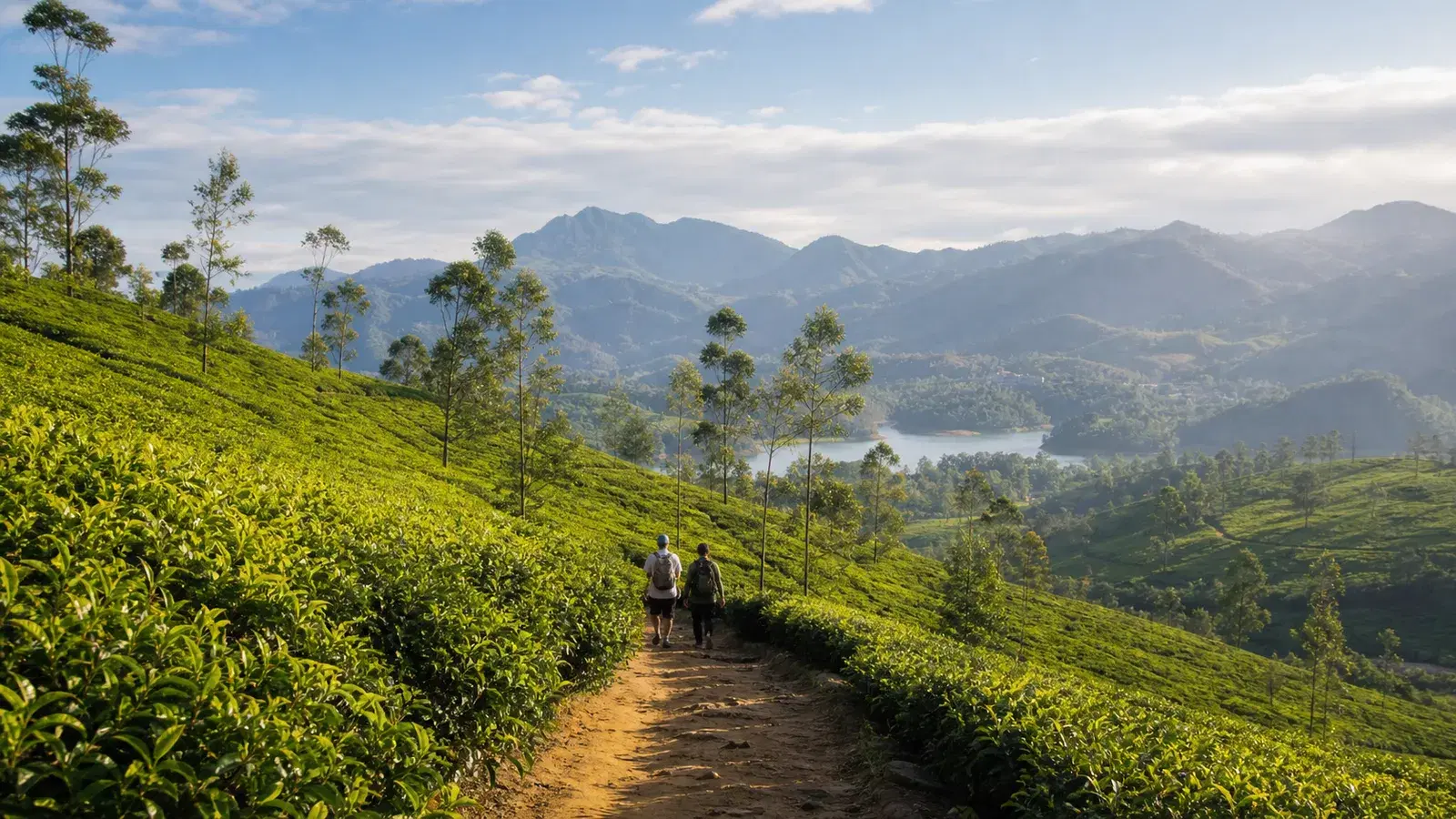
  • The highest point sits at around 1,008 m at the 5.7 km mark, with views over Victoria Reservoir and the Knuckles Range on a clear day
  • Much of the route follows concrete and gravel estate roads rather than narrow footpath, so this is a scenic walk more than a technical hike
  • People interaction along this stage is rated High, meaning you will pass houses, shops and workers regularly, which is a strength for first-timers and a drawback if you came for solitude
  • Kandy is currently reached by road rather than rail because of the ongoing Main Line closure, so build extra transfer time into your plan

What the Pekoe Trail Is, and Where Stage 1 Fits

The Pekoe Trail is a long-distance walking route of more than 300 km through the Central Highlands of Sri Lanka, divided into 22 stages. It was conceived by Miguel Cunat and developed with funding from the European Union and additional support from USAID, before being handed to a non-profit called The Pekoe Trail Organisation to manage.

The route links Kandy, Hatton, Horton Plains, Haputale, Ella, Uda Pussellawa and Nuwara Eliya, passing through roughly 21 tea estates along the way. The word pekoe refers to a grade of tea made from young leaves, which tells you where the trail's heart is.

The stages are grouped loosely by region. Stages 1 to 5 sit in the Kandy area, stages 6 to 10 around Hatton, stages 11 to 14 near Haputale, stages 15 to 18 around Ella, and stages 19 to 22 in the Nuwara Eliya area.

The crucial thing for most travellers to understand is that the trail was explicitly designed to be walked in pieces. You are not expected to commit to the whole thing. Walking one stage as a day hike is a completely normal and intended use of the route, and it is what the large majority of foreign visitors actually do.

Stage 1 is the natural entry point, both geographically and in difficulty. It starts within easy reach of Kandy, which most itineraries already include, and it is one of the few stages in the Kandy cluster rated Easy. Stages 2, 3 and 4 are all rated Difficult, which is a steep jump if you start at number two by accident.

Walking Stage 1 first also lets you calibrate honestly. If 13 km of estate road with 537 m of climbing leaves you comfortable and wanting more, the harder stages are open to you. If it leaves you exhausted, you have learned that cheaply and without being stuck halfway up a mountain in a landslide zone.

22 stages, 300+ km, Central HighlandsDesigned to be walked in sectionsStage 1 is the gentlest Kandy-area stageStages 2, 3 and 4 are all rated DifficultManaged by a non-profit, not a government park authority

The Stage 1 Numbers, and Where They Contradict Each Other

Here is what the Pekoe Trail Organisation publishes for Stage 1: length 13.01 km, elevation gain 537 m, elevation loss 470 m, maximum elevation 1,067 m, region Kandy, people interactions High, difficulty Easy in both forward and reverse directions.

Now here is the awkward part. The organisation's own stage index page lists the same stage as 12.84 km with an average duration of 4 hours, while the dedicated Stage 1 page lists 13.01 km with an average duration of 3 hours. Both pages are official. They do not agree.

The elevation has a similar wrinkle. The stage summary box gives a maximum elevation of 1,067 m, but the official route description states that the trail reaches its highest elevation of 1,008 m at the 5.7 km mark. Those are different numbers describing the same walk.

Third-party sources spread the range further. AllTrails users log roughly 13 km with about 500 m of gain and around four to four and a half hours. At least one commercial operator publishes eight hours for the same stage. GPS tracks uploaded to Wikiloc land in between.

We are not going to pretend one of these is definitively right, because we cannot verify that and neither can any other blog. What we can tell you is how to plan sensibly around the disagreement.

The three-hour figure is a moving time for a fit walker with no stops. It is achievable and it is also not what your day will look like. Add photography, a tea and banana break at the shop near the 1.4 km mark, lunch, the inevitable slowing down on the descent, and the very real possibility that you will stop to look at Victoria Reservoir for longer than you planned.

Our working planning figure is 4 to 6 hours of elapsed time for a typical foreign visitor of average fitness. Budget a full day from Kandy once you include the transfer at both ends. If you finish early, you have gained a relaxed afternoon rather than lost a bus.

Official length: 13.01 km (12.84 km on the index page)Official duration: 3 hours on one page, 4 hours on anotherElevation gain around 537 m, loss around 470 mPlan 4 to 6 hours elapsed, not 3Budget a full day once transfers are included

The Trail Pass: USD 10 Per Stage, and Why Most Guides Do Not Mention It

This is the single biggest thing that has changed about the Pekoe Trail since most of the articles currently ranking on Google were written, and it is the reason a lot of travellers arrive at the trailhead with outdated expectations.

The Pekoe Trail now operates a trail pass. Foreign visitors pay USD 10 per stage. Sri Lankan residents pay LKR 600 per stage. Children under 12 are free. Members of The Pekoe Trail Organisation get unlimited passes at no additional cost, which is worth doing the maths on if you intend to walk several stages.

You buy the pass through the official Pekoe Trail web portal or the Pekoe Trail app, using the same email address for both. Select the stage or stages you plan to walk, complete payment, and the pass loads into the app for you to present during the hike.

The reasoning the organisation gives is straightforward and worth understanding rather than resenting. The trail was built with donor funding that has now ended. The route crosses a patchwork of public land, private tea estates and village land, and access exists because landowners agreed to it. The organisation states plainly that landowners may restrict access or ask you to leave if you are not carrying a valid pass. Pass revenue funds path and bridge maintenance, signage, the navigation app, safety updates and community programmes.

Here is the honest practical picture. There is no ticket booth at the Ceylon Tea Museum. Nobody scans you onto Stage 1. In practice, a foreign hiker who skipped the pass would very likely walk the whole stage without being challenged.

We are still telling you to buy it. This is a non-profit maintaining a route across other people's land in a country where the tourism benefit of that arrangement flows to rural communities. Ten dollars is less than most travellers spend on lunch in Kandy, and the alternative arrangement, where the trail quietly degrades because nobody funds it, is worse for everyone including you.

Note separately that certain stages may require additional tickets or permits for protected areas and private land on top of the trail pass. Stage 1 does not have that complication, but stages further along the route do, so do not assume a pass covers everything everywhere.

USD 10 per stage for foreign visitorsLKR 600 per stage for Sri Lankan residentsUnder-12s free; members get unlimited passesBought via the official app or web portalNo checkpoint on Stage 1, but landowner access depends on it

Getting to the Trailhead in 2026, Including the Train Problem

Stage 1 begins at the Ceylon Tea Museum on the Hanthana Estate, a short drive south of Kandy city. It ends at Galaha Post Office. Both points are easy to give a driver, and both have Google Maps entries under those names.

The museum has ample parking and, usefully for a trailhead, good toilet facilities. It occupies the shell of the old Hanthana Tea Factory and is genuinely worth thirty minutes of your time before you start walking, particularly if this is your first exposure to how Ceylon tea is made.

There is an important 2026 caveat about reaching Kandy in the first place. Cyclone Ditwah damaged the hill country Main Line in late 2025. Trains are running Colombo to Rambukkana and Nanu Oya to Ella and Badulla, but the Rambukkana to Nanu Oya section, which passes through Kandy, remains closed for repairs with reopening expected around January 2027.

In practical terms that means you cannot currently take the classic Colombo to Kandy train. Kandy is reached by road, roughly three to four hours from Colombo depending on traffic and the expressway routing your driver chooses. Plan accordingly, and read our dedicated guide to what is and is not running before you lock in any hill country itinerary.

From Kandy itself, the museum is a straightforward tuk-tuk or taxi ride. From Galaha at the far end, local buses connect back toward Kandy, though schedules are informal and the last useful service is earlier than tourists expect.

The far more common arrangement, and the one we would suggest for most visitors, is a single driver for the day. They drop you at the museum, drive round to Galaha, and wait. This removes the whole problem of finishing a hike at four in the afternoon in a small hill town with no obvious way back. Agree the pickup point and an approximate time before you set off, and share a phone number.

Mobile signal along this stage is rated poor. Do not assume you can call your driver from the ridge to renegotiate. Fix the arrangement before you start.

Start: Ceylon Tea Museum, Hanthana. End: Galaha Post OfficeKandy is currently road-access only due to the Main Line closureParking and toilets at the trailheadA driver for the day removes the return-transport problemMobile signal is poor along the route

The Route, Kilometre by Kilometre

From the Ceylon Tea Museum the trail climbs gently through the Hanthana Tea Estate, one of the oldest and largest plantations in the country. The road is lined with tall trees for much of this opening stretch, which matters more than it sounds when you are walking uphill in tropical sun.

As you climb, Kandy opens up behind you and the seven peaks of the Hanthana range come into view ahead. This early section is the one most people photograph and it sets a slightly misleading tone, because it is prettier and shadier than the middle of the stage.

At around 1.4 km the trail reaches a crossroads with a small shop. This is your realistic last easy refreshment point for a while. Thambili, the local king coconut, and bananas are the standard purchases, and buying here is a small direct contribution to a community along the route.

The path continues on concrete past the W15 hotel and the Hill Country Sport Shooting Club, climbing steadily. By roughly 3.1 km you pass the Sugarcane Quarantine Centre. This middle section is where the walk feels most like a road and least like a trail, and it is the part nobody puts in the Instagram carousel.

The surface then changes from concrete to gravel with cabanas along the way. At about 5.2 km a side trail leads to a secluded stupa used for meditation. The trail organisation asks visitors not to disturb it and that is a request worth honouring rather than testing.

The high point of the stage comes at around 5.7 km at roughly 1,008 m. On a clear day this is the payoff: Victoria Reservoir spread out below and the ridgeline of the Knuckles Range beyond it. On a misty day you will see grey. Both are normal.

From the high point the trail descends gently towards Galaha through changing scenery, including a dense stand of tall trees around the 10 km mark and a scattering of village houses. This is the area where parts of Indiana Jones and the Temple of Doom were filmed, which is a pleasant piece of trivia rather than a visitable site.

The lowest point of the stage is at about 10.8 km and 754 m, where you cross a bridge over a river and enter a pine forest. From here you have a choice between a steep track up the hill or a longer bend in the road. Both reach Galaha Road, and the stage formally ends at Galaha Post Office roughly 900 m further on.

One thing worth flagging: because the profile finishes low and the final kilometres are downhill on hard surfaces, this stage is easier on the lungs than on the knees. Walking poles are more useful here than the Easy rating suggests.

Shaded climb through Hanthana Tea Estate at the startShop at 1.4 km for thambili and bananasHigh point around 5.7 km at roughly 1,008 mVictoria Reservoir and Knuckles Range views on clear daysPine forest and river crossing near 10.8 kmFinishes at Galaha Post Office

Navigation and Waymarking: How Lost Can You Actually Get?

The Pekoe Trail is marked, but the standard of marking is not consistent along its length and Stage 1 has historically been described in official material as walkable but not fully signposted.

In practice, Stage 1 is one of the easier stages to follow because so much of it runs on identifiable estate roads rather than faint footpaths through vegetation. Hikers commonly describe following orange dots and arrows on trees and posts, and the general line of travel is intuitive once you are on it.

The two places people report difficulty are the very start, where finding the correct path out of the museum area is less obvious than it should be, and the final descent, where the choice between the steep track and the road bend confuses people who are tired and expecting a single answer.

Download the official Pekoe Trail app before you leave your accommodation. It carries the stage routes, gives off-track alerts if you stray from the designated path, and holds your trail pass. Off-track alerts are the feature that matters most, because the failure mode on this stage is not dramatic; it is walking twenty minutes down a plausible-looking estate road before realising.

Because mobile signal is poor along the ridge, download offline maps in advance rather than relying on live data. Maps.me and organic maps both handle Sri Lankan estate roads reasonably well as a backup. GPX tracks for this stage are available on both AllTrails and Wikiloc if you prefer a dedicated GPS app.

You do not need a guide for Stage 1 in the way you need one for some later stages. If you are a confident hiker with a charged phone and a downloaded route, you will be fine. If you are nervous about navigation, or you want the cultural layer that turns a walk into an experience, a local guide is worth it here and considerably more worth it on stages 2 and 3.

Mostly follows identifiable estate roadsOrange dots and arrows are the trail markersOfficial app has off-track alerts and holds your passDownload offline maps because signal is poorA guide is optional on Stage 1, unlike some later stages

How Hard Is It Really? An Honest Difficulty Assessment

The official grading is Easy, forward and reverse. That grading is relative to the rest of the Pekoe Trail, where several stages exceed 800 m of climbing and one exceeds 21 km. Judged against its siblings, Stage 1 is genuinely gentle.

Judged against the fitness of the average holidaymaker, it is a moderate day. Thirteen kilometres with 537 m of ascent is a real walk. If your usual exercise is a treadmill twice a week, you will feel this the next morning.

Three specific factors make it harder than the raw numbers imply. The first is heat. Much of the middle section has limited shade and Sri Lankan hill-country sun at midday is stronger than most European or North American visitors expect at 1,000 m.

The second is surface. A high proportion of the stage is concrete or gravel road rather than soft trail. This is easy underfoot in terms of footing and unkind in terms of impact, particularly on the sustained descent into Galaha.

The third is humidity. The official guidance is to drink at least half a litre of water per hour while hiking here, and that is not conservative advice. Carry at least two litres and treat any stream water you take on rather than drinking it untreated.

Who this stage suits: reasonably active adults, teenagers, older walkers who hike regularly, and families with children who are used to long walks. Who it does not suit: anyone who has not walked more than a few kilometres at a stretch in the last year, and anyone hoping to combine it with a full sightseeing afternoon in Kandy on the same day.

If you want the scenery without the full distance, an out-and-back from the museum to the high point at 5.7 km and return is about 11.4 km with most of the good views included, and it removes the transport-at-both-ends problem entirely.

Easy relative to other Pekoe stages, moderate in absolute termsHeat and lack of shade are the main difficulty multipliersHard surfaces make the descent tough on kneesDrink at least half a litre of water per hourOut-and-back to the 5.7 km high point is a good shorter option

When to Walk Stage 1

The commonly repeated advice is that the Pekoe Trail is best hiked in the dry season from December to March, and for this part of the Central Highlands that broadly holds. Clearer skies mean the Victoria Reservoir and Knuckles views actually materialise rather than sitting behind cloud.

January to April is our practical recommendation for this stage. Trail surfaces are firmer, leech pressure is lower, and the tea plucking cycle is active, so the estates look and feel alive rather than dormant.

The Kandy region sits in a transitional zone between Sri Lanka's two monsoon systems, which is why blanket statements about the island's weather rarely work here. The southwest monsoon roughly from May to September brings the heavier rainfall to this side of the highlands. The northeast monsoon from around October to January affects the eastern slopes more.

That said, this stage is not closed in the wet months and plenty of people walk it then. What changes is the experience: greener and more dramatic, but with slippery estate roads, a much higher chance of leeches in the forested sections, and a genuine possibility of walking the whole ridge without seeing the view you came for.

Time of day matters as much as time of year in the highlands. Mist typically builds through the afternoon. Starting at 7 or 8 in the morning gives you the best odds of reaching the 5.7 km high point while the air is still clear, and it also keeps the exposed middle section out of peak sun.

The official stage page carries a standing advisory about wet and slippery sections after rainfall. Check it, and check the TrailWatch app, the night before you walk. Conditions on hill country trails change faster than published guides can keep up with, which is precisely why we point you to the live source rather than asking you to trust a date-stamped paragraph.

January to April is the strongest windowSouthwest monsoon roughly May to September brings the wetStart early to beat the afternoon mistWet season is walkable but leechier and view-limitedCheck TrailWatch the night before

Leeches, Dogs and the Things Nobody Warns You About

Leeches are the number one unpleasant surprise for first-time hikers in the Sri Lankan highlands, and they are entirely manageable once you stop being surprised by them.

They appear after rain, in shaded and forested sections, and in damp leaf litter. Stage 1 has less leech exposure than Stage 2's pine forest, but the wooded stretch near 10 km and the pine forest after the river crossing are both plausible territory in wet conditions.

Leech socks are the effective solution. They are long, tightly woven fabric socks worn over your normal socks and under or over your trouser legs. They are widely sold in Sri Lanka and are the single most useful five dollars you will spend on hill country hiking. Repellent products exist and help as a backup, but socks are the primary defence.

If one attaches, do not pull or burn it. Let it finish or ease it off sideways at the mouth end, then clean and cover the bite. Leeches in Sri Lanka do not transmit disease to humans; the bite bleeds longer than seems reasonable because of the anticoagulant, which is unnerving the first time and harmless.

Village dogs are the other thing official documentation lists among the hazards on this route, alongside steep terrain, difficult route-finding, heavy rain, thunderstorms and sun. Most are indifferent to walkers. A minority will bark and follow. Do not run, do not make eye contact, keep walking steadily, and pick up a stick if it genuinely helps your confidence, though you will almost certainly never need it.

Thunderstorms deserve more respect than dogs. Highland storms build fast in the afternoon and the exposed ridge section around the high point is not where you want to be during one. This is another argument for an early start.

Finally, the trail organisation asks hikers to carry out all their rubbish and to pick up any they find, even a single bottle. It is a small ask and the estates you are walking through are people's workplaces.

Leech socks are the primary defence, not repellentLeech bites are harmless but bleed persistentlyVillage dogs are common and rarely a real problemAfternoon thunderstorms are the genuine risk on the ridgeCarry out all rubbish, including other people's

What to Pack for a Single Pekoe Stage

You are not packing for an expedition. You are packing for a day walk in a tropical highland climate with limited resupply and unreliable weather, which is a specific combination that catches people out.

Water is the first priority. Carry at least two litres per person. The shop at 1.4 km is the reliable resupply point and after that you are into village shops that may or may not be open. Do not plan on buying water at the halfway mark.

Footwear should be trail shoes or light hiking boots with real grip. Trainers with worn soles are the most common footwear mistake on this stage, because a lot of the route is smooth concrete that becomes genuinely slick when wet.

Sun protection matters more than jacket weight. A hat, sunscreen and sunglasses for the exposed middle section, plus a light rain shell or poncho that packs small, covers most of what the weather can do to you in a day.

Layers rather than warmth. At 1,000 m in the Kandy district you are not going to be cold while moving, but a long-sleeved layer is useful against sun as much as temperature, and against scratchy vegetation on narrower sections.

Cash in small denominations. The shops, tuk-tuks and village stalls along the route do not take cards. Carry small notes rather than expecting change for large ones.

Then the specifics: leech socks if there has been recent rain, a small first aid kit with plasters and antiseptic, snacks, a power bank because navigation apps drain batteries fast, offline maps downloaded, your trail pass loaded in the app, and the phone numbers for your driver and accommodation saved rather than looked up mid-hike.

Walking poles are optional but genuinely useful on the long descent into Galaha, particularly if you have knee issues.

At least two litres of water per personTrail shoes with grip, not worn trainersHat, sunscreen, and a packable rain layerSmall denomination cash for village shopsPower bank, offline maps, and pre-saved contact numbers

Should You Hire a Guide for Stage 1?

We will give you the straight answer first: for Stage 1 specifically, a guide is a nice-to-have rather than a necessity for most confident hikers. This is not true of every stage on the trail and it is worth understanding why.

Stage 1 is short by trail standards, rated Easy, follows recognisable roads for most of its length, passes through populated areas where you can ask directions, and has a people-interaction rating of High. If you get confused, there is usually somebody to ask.

The case for hiring one anyway is not about safety. It is about what you understand. Walking past a tea weighing station means very little if nobody explains what happens there. The plucking cycle, the difference between the estate divisions, why certain slopes are planted and others left as forest, what the workers' housing lines represent socially and historically in this country: none of that is legible from a trail marker.

There is also a direct economic argument. Guiding is one of the few ways trail traffic converts into income for the communities the route passes through, which is the stated purpose of the whole project. A guide fee stays local in a way that an app subscription does not.

How to choose one: look for someone who hikes this specific stage regularly rather than a general Kandy city guide, ask what their plan is if weather turns, confirm whether the fee includes their transport and food, and agree a start time that gets you to the high point before the afternoon mist. Ask whether they carry a basic first aid kit.

We do not name individual guides or companies on this site. That is deliberate, and it applies to hotels, drivers and tour operators equally. What we will do is give you the criteria to judge them yourself, and point you toward the vetted local guides on our own platform if you would rather not sort through it alone.

For stages 2 and 3, our advice shifts. Stage 2 currently carries an active landslide advisory recommending against solo hiking, and Stage 3 has a Low people-interaction rating across remote terrain. On those, local knowledge stops being a luxury.

Optional for Stage 1 for confident hikersThe real value is interpretation, not navigationGuide fees keep tourism revenue in trail communitiesChoose someone who walks this stage specificallyStrongly recommended on Stages 2 and 3

Where to Base Yourself

For a single-stage day hike, Kandy is the obvious and best base. It has the widest range of accommodation, restaurants, ATMs and drivers, and it puts you within a short transfer of the trailhead.

Staying in Kandy also means the rest of your day is usable. The Temple of the Sacred Tooth Relic, the Royal Botanical Gardens at Peradeniya, and the lake are all realistic additions to the day before or after your walk, though we would not try to do the gardens and the full stage in the same daylight hours.

The Hanthana area immediately around the trailhead has a small cluster of hillside properties with views back over Kandy. Staying up there gives you a genuine advantage: you can start walking at first light without a pre-dawn transfer, which is the single best thing you can do for your odds of a clear view at the high point.

Galaha at the far end is a small hill town rather than a tourist base. There is accommodation in the wider area, including estate bungalows, but it is thin and you should not arrive expecting to find a room on the day.

If you are planning to continue onto Stage 2, staying at the Galaha end makes sequential sense. If you are treating Stage 1 as a standalone day hike, Kandy is more practical.

Whichever you choose, check three things before booking: the exact location relative to the trailhead rather than the town name, whether the property can arrange or recommend a driver, and whether they will do an early breakfast or a packed one. That last question sounds trivial and it decides whether you start at seven or nine.

As with guides, we do not name specific hotels or guesthouses. The Pekoe Trail Organisation maintains its own accommodation directory of partner properties along the route, which is a reasonable starting point precisely because those properties have a relationship with the trail.

Kandy is the practical base for a day hikeHanthana-area stays allow a first-light startGalaha is a small town, not a tourist baseAsk about early or packed breakfast before bookingThe official accommodation directory lists partner properties

Combining Stage 1 With the Rest of Your Trip

Stage 1 slots into a standard Sri Lanka itinerary more easily than any other part of the Pekoe Trail, because Kandy is already on almost everyone's route between the Cultural Triangle and the hill country.

The cleanest version is a full day inserted into a Kandy stay: walk the stage, return to the city, rest. Do not try to also do the Temple of the Tooth in the evening if you have been walking since seven.

If you have two days and want more trail, the natural continuation is Stage 2 from Galaha to Loolkandura, which reaches the birthplace of Ceylon tea at the Loolecondera Estate. Be aware before you commit that Stage 2 is rated Difficult and currently carries an active advisory about landslide damage on part of its route. We cover that stage in full in a separate guide and we would not have you walk into it unbriefed.

For a bigger commitment, stages 1, 2 and 3 taken together form a coherent three-day arc from Kandy to Tawalantenne, moving from populated estate roads into genuinely remote highland forest. That sequence is the classic introduction to the trail and it ends within reach of the Nuwara Eliya road.

If the hill country in general is your priority rather than the trail specifically, Stage 1 pairs naturally with the tea estates around Nuwara Eliya and with the Knuckles Range, which you can actually see from the high point of this stage.

One scheduling note worth repeating because it derails plans: with the Rambukkana to Nanu Oya railway section closed until repairs finish, the classic Kandy to Ella train journey is not currently available. Hill country movement is by road for now, which means longer transfers and a different itinerary shape than the guidebooks assume. Check the current position before you build a tight schedule around trains.

Fits neatly as a full day within a Kandy stayStages 1 to 3 form a natural three-day arcStage 2 is Difficult and carries a live advisoryPairs well with Knuckles and Nuwara Eliya tea countryHill country trains are partly out of service in 2026

Walking This Stage Responsibly

The Pekoe Trail exists because landowners, estates and villages agreed to let strangers walk across land they live and work on. That agreement is the entire foundation of the route and it is more fragile than it looks.

Stay on the marked path through tea estates. The temptation to cut between rows for a better photograph is the single most common breach and it damages bushes and irritates the people whose income depends on them.

Ask before photographing people. Tea pluckers are working, not posing. A greeting first, a question second, and an acceptance of no as an answer is the standard. This applies equally to houses, estate bungalows and religious sites along the route.

The stupa at around 5.2 km is used for meditation and the trail organisation explicitly asks visitors not to disturb it. Treat kovils and temples along the way the same way: shoes off where indicated, shoulders and knees covered, no photographs during observances.

Buy something local. The shop at 1.4 km, a meal in Galaha, a tuk-tuk ride, a guide's day rate. The trail's stated purpose is bringing economic opportunity to rural communities, and that only happens if walkers actually spend money along the way rather than arriving with packed lunches from a Kandy supermarket and leaving nothing behind but footprints.

Carry out all your waste. The official guidance goes further and asks you to pick up other people's litter where you can, even a single bottle or plastic bag.

Drones need permission. Estate land is private property and flying over workers' housing without asking is not acceptable regardless of what the law technically permits.

Group size is capped at 20 people under trail policy. If you are organising a larger party, split it and stagger your starts.

Stay on the marked path through estatesAsk before photographing workers or homesDo not disturb the meditation stupaSpend money locally along the routeGroup size capped at 20 under trail policy

Should You Actually Walk Stage 1? An Honest Verdict

We would rather you skipped this walk than did it disappointed, so here is the plain assessment.

Walk Stage 1 if you want a proper half-to-full day on foot in the tea country, you are reasonably fit, you like landscape and agricultural scenery, and you are curious about the trail without wanting to commit to a multi-day trek. It is genuinely lovely and it is the most accessible piece of a nationally significant project.

Walk it if you have a fixed Kandy stay and are looking for something to do that is not another temple or garden. As a day out from Kandy it is one of the better options available and far less crowded than the standard circuit.

Do not walk it if you came to Sri Lanka for wilderness. The people-interaction rating is High for a reason, and a significant proportion of the route is on made road within earshot of houses and traffic. That is not a criticism of the stage; it is what a trail through inhabited tea country looks like. But if you are picturing empty mountains, Stage 3 or the Knuckles Range will serve you better.

Do not walk it if you are short on time and this would be your only hiking day in the highlands. If you have exactly one hiking day and you want maximum drama for the effort, the Knuckles Range or a Horton Plains morning delivers more spectacle per hour.

Do not walk it in the wrong footwear or without water. This sounds obvious and it is the most common reason people have a miserable time on a stage that should have been pleasant.

For the traveller it does suit, which is a lot of people, this is a rewarding, well-conceived, and genuinely different day in Sri Lanka. It is also the low-commitment way to find out whether the other 21 stages are calling you.

Best for: reasonably fit walkers based in KandyGreat low-commitment introduction to the trailNot wilderness: High people-interaction ratingKnuckles or Horton Plains deliver more drama per hourFootwear and water are the two things people get wrong

Travel Tips

  • Buy your trail pass before you set off; it costs USD 10 per stage for foreign visitors and loads directly into the official app
  • Plan on 4 to 6 hours elapsed rather than the 3 hours listed on the official stage page
  • Start by 7:30 am at the latest to reach the high point before afternoon mist builds
  • Carry at least two litres of water and drink around half a litre per hour
  • Download the Pekoe Trail app and an offline map because mobile signal along the route is poor
  • Wear trail shoes with real grip; wet concrete estate roads are slippery
  • Pack leech socks if there has been rain in the previous few days
  • Arrange a driver to meet you at Galaha Post Office rather than relying on local buses
  • Buy thambili or bananas at the shop near the 1.4 km mark to support businesses on the route
  • Carry small denomination cash; nowhere along the route takes cards
  • Check the official stage advisory and the TrailWatch app the night before you walk
  • Save your driver's and accommodation's phone numbers offline before you start
  • Walking poles help considerably on the long descent into Galaha
  • Remember that Kandy is currently reached by road, not by train, so build in longer transfer times

Frequently Asked Questions

How long is Pekoe Trail Stage 1?

The Pekoe Trail Organisation lists Stage 1 as 13.01 km on the stage page and 12.84 km on its stage index, with around 537 m of elevation gain and 470 m of loss. In practical terms it is a 13 km walk.

How long does Stage 1 take to walk?

Published figures disagree. The official stage page says 3 hours, the official index page says 4 hours, AllTrails users log around 4 to 4.5 hours, and at least one operator advertises 8 hours. We suggest planning 4 to 6 hours of elapsed time including stops, and reserving a full day once transfers are counted.

Do I need a permit or pass for the Pekoe Trail?

Yes. The Pekoe Trail Organisation operates a trail pass system. Foreign visitors pay USD 10 per stage, Sri Lankan residents pay LKR 600 per stage, and children under 12 are free. Organisation members receive unlimited passes. Passes are bought through the official app or web portal. There is no checkpoint on Stage 1, but landowners may restrict access to hikers without one.

Where does Stage 1 start and end?

It starts at the Ceylon Tea Museum on the Hanthana Estate south of Kandy and ends at Galaha Post Office. Both have parking, and the museum also has good toilet facilities.

Is Stage 1 suitable for beginners?

It is the most beginner-friendly stage in the Kandy cluster and is graded Easy in both directions. That said, 13 km with 537 m of climbing in tropical heat is still a real day's walk. Reasonably active adults and teenagers will manage it comfortably; people who rarely walk long distances will find it demanding.

Can I hike Stage 1 without a guide?

Yes, most confident hikers do. The stage follows recognisable estate roads for much of its length, passes populated areas where you can ask directions, and is covered by the official app with off-track alerts. A guide adds interpretation and local income rather than being a safety necessity on this particular stage.

What is the best time of year to walk Stage 1?

January to April generally offers the driest conditions and the best chance of clear views toward Victoria Reservoir and the Knuckles Range. The stage is walkable year-round, but the southwest monsoon months bring slippery surfaces, more leeches and frequent cloud.

Are there leeches on Stage 1?

Yes, particularly after rain in the wooded stretch near the 10 km mark and the pine forest after the river crossing. Leech socks are the effective defence. Bites are harmless but bleed persistently because of the anticoagulant.

How do I get to Kandy in 2026?

By road. Cyclone Ditwah damaged the hill country Main Line in late 2025 and the Rambukkana to Nanu Oya section, which passes through Kandy, remains closed with reopening expected around January 2027. Trains still run Colombo to Rambukkana and Nanu Oya to Ella and Badulla. Confirm the current position before finalising your plans.

Where can I get water and food on the route?

There is a small shop at around the 1.4 km mark selling thambili and bananas, and further village shops appear intermittently. Do not rely on finding anything open at the halfway point. Carry at least two litres of water and your own snacks.

Is there mobile signal on Stage 1?

Signal along the route is rated poor. Download offline maps and the stage route in advance, save important phone numbers before you start, and confirm your pickup arrangement before setting off rather than expecting to call from the ridge.

Can I do Stage 1 as a shorter walk?

Yes. An out-and-back from the Ceylon Tea Museum to the high point at around 5.7 km and return is roughly 11.4 km, includes the best views of the stage, and removes the need for transport at the Galaha end.

What is the difference between Stage 1 and Stage 2?

Stage 1 is 13 km, graded Easy, with a High people-interaction rating. Stage 2 is 14.7 km, graded Difficult, climbs 853 m to a maximum of 1,402 m, and reaches the historic Loolecondera Estate. Stage 2 also currently carries an active advisory about landslide damage on part of its route, with solo hiking discouraged.

Is Stage 1 family friendly?

For families with children who are used to long walks, yes. The gradients are gentle, the route is populated, and there are regular points to stop. For younger children or those unaccustomed to distance, the out-and-back to the high point is a better plan than the full stage.

Reader notes

Join the conversation

Share your question, tip, or travel experience for this guide.

Comments

0 comments

Loading...

Ready to turn inspiration into a Sri Lanka trip?

Use LankaTrip to plan your journey, connect with local guides, and make this itinerary a reality.

Need help planning?

Plan your Sri Lanka adventure

Plan my trip