
LankaTrip Insights

29 min read

Pekoe Trail Stage 10 in 2026: Dayagama to Horton Plains, the Most Expensive and Most Logistically Difficult Stage on the Trail

Stage 10 climbs 983 m from Dayagama to 2,138 m inside Horton Plains National Park, and almost none of its difficulty is in the walking. The park ticket, the 2 pm entry cutoff and the driver logistics are what make or break this day.

Back to blog
Pekoe Trail Stage 10 in 2026: Dayagama to Horton Plains, the Most Expensive and Most Logistically Difficult Stage on the Trail

Every guide to the Pekoe Trail will tell you Stage 10 is difficult. Almost none of them explain that the difficulty is mostly administrative.

The walking is demanding but honest: 15.88 km with 983 m of climbing and almost no descent, on trails the official description calls well-marked and manageable. If that were all there was to it, this would be a hard but straightforward day.

It is not all there is to it. Stage 10 finishes inside Horton Plains National Park, and that changes everything about how you plan it.

You need a national park ticket on top of your trail pass. The trail organisation gives the fee as approximately USD 45, which makes this by some distance the most expensive single stage on the Pekoe Trail. Ten dollars for the trail pass and roughly forty-five for the park is a different order of cost from every other stage on the route.

You need to be through the park entry by 2 pm, because entry from this stage is not possible after that. On a stage we estimate at 6 to 8 hours with the park boundary at around 9.5 km, that is a real constraint rather than a formality.

And you need a driver who understands that the endpoint is 15 km away on foot and around 65 km away by road, because the road loops back through Nuwara Eliya. The trail organisation's own guidance says to ensure your driver is well coordinated and notes they will likely arrive just before you do.

Get those three things right and this is one of the great days on the trail: a sustained climb out of the remotest corner of the tea country into Sri Lanka's cloud forest. Get any of them wrong and the day fails before you have walked a step.

This guide covers the logistics first, because that is where the actual difficulty lives, and then the walking.

Quick Summary

  • Stage 10 runs 15.88 km from Dayagama to Horton Plains, gaining 983 m and losing only 216 m
  • It reaches around 2,138 m, the highest point on the trail in its first ten stages
  • It is graded Difficult in both directions with an official average duration of 5 hours; plan 6 to 8 hours
  • A Horton Plains National Park entrance ticket is required in addition to the USD 10 trail pass
  • The trail organisation gives the park fee as approximately USD 45, subject to exchange rate movement
  • Entry to the park from this stage is not possible after 2 pm, which forces a very early start
  • The endpoint is only 15 km from the start on foot but around 65 km by road, so driver coordination is critical
  • The same park ticket also covers World's End, Baker's Falls, Kirigalpotha and Thotupola Kanda

The Park Ticket: What It Costs and Where to Buy It

Horton Plains is a national park managed by the Department of Wildlife Conservation, and walking through it requires a ticket. Your Pekoe Trail pass does not cover this and never has.

The trail organisation states the entrance fee costs approximately USD 45, subject to exchange rate fluctuations. National park fees in Sri Lanka are typically set in dollars and collected in rupees, with additional service charges and taxes that vary, which is why a single clean figure is hard to pin down.

We are giving you the trail organisation's figure rather than inventing a more precise one, and we would strongly suggest confirming current rates with the Department of Wildlife Conservation before you travel. Park fees in Sri Lanka are revised periodically and any number published in an article ages quickly.

What matters for planning is the order of magnitude. This stage costs roughly five to six times what any other stage on the trail costs. Budget accordingly, and factor it in when deciding which stages to walk if cost is a consideration.

Tickets must be purchased at the park entrance, either the Dayagama entrance or the Ohiya entrance, before entering the park. You cannot buy one inside, and you cannot buy one from the trail app.

The Dayagama entrance is the relevant one for this stage since you start in Dayagama, but note that the entrance is not the same thing as the village. Confirm exactly where the ticket office is and factor the time into your morning.

There is a genuine planning trap here. You start walking in Dayagama, walk 9.5 km on tea trails, and only then reach the park. If your ticket arrangement is not sorted before you set off, you have walked nearly ten kilometres to a boundary you cannot cross.

Sort the ticket first. Ask your accommodation or driver to help, since local knowledge about where and when the office operates is worth more than anything published online.

The trail pass does not cover national park entryThe trail organisation gives the fee as approximately USD 45Confirm current rates with the Department of Wildlife ConservationTickets are bought at the Dayagama or Ohiya entrance, not insideSort the ticket before you start walking, not at the boundary

The 2 pm Cutoff and Why It Forces an Early Start

The trail organisation states plainly that entry to the park from this stage is not possible after 2 pm.

This is the constraint that shapes the entire day, and it is the single most likely reason a hiker fails to complete Stage 10.

Work backwards. The park boundary sits at around the 9.5 km mark, after a sustained climb. If you are walking at a reasonable pace with stops, that is roughly four to five hours from Dayagama for most people.

To be comfortably inside by 2 pm you want to be walking by 8 am at the very latest. To have margin for a slow start, a navigation issue or simply a bad day, we would suggest starting between 6 and 7 am.

Add the ticket purchase before that, and the transfer to the trailhead if you are not staying in Dayagama, and you are looking at a genuinely early morning.

This is the strongest argument for staying in Dayagama the night before rather than driving in from Nuwara Eliya or Hatton. Dayagama is remote and accommodation is limited, but a pre-dawn transfer along hill country roads to reach a 6 am start is worse.

The cutoff also interacts with the broader special trail hours flag on the stage index for Stage 10. The trail organisation's general guidance says most stages are open 6 am to 6 pm with some shorter, particularly in wildlife corridors and protected areas. For Stage 10 the 2 pm park entry restriction is the specific and published version of that.

One more consideration. If you walked Stage 9 the day before, that is a Hard-graded 17 km day finishing in Dayagama. Arriving tired in the evening and then starting at 6 am is a demanding sequence. A rest day between stages 9 and 10 is worth considering seriously.

There is no flexibility in this. Park entry cutoffs are enforced and arguing at a gate at 2:15 pm will not work.

Entry from this stage is not possible after 2 pmThe park boundary sits at around 9.5 km, four to five hours inStart between 6 and 7 am to have real marginStay in Dayagama the night before rather than transferring pre-dawnConsider a rest day if you walked Stage 9 the previous day

The 15 Kilometre Walk That Is a 65 Kilometre Drive

This is the logistical problem that catches out people who have planned everything else correctly.

The endpoint of Stage 10 is the old Far Inn inside Horton Plains National Park. On foot, that is about 15 km from Dayagama. By road, the trail organisation notes it is around a 65 km drive, because the road loops back around through Nuwara Eliya.

There is no shortcut. The topography that makes this stage a spectacular climb is the same topography that makes the road detour four times the walking distance.

The official guidance says to ensure your driver is well coordinated, and that they will likely arrive at the endpoint just before you do. That is a polite way of saying this arrangement requires actual planning rather than a phone call on the day.

What to agree in advance: the exact meeting point at the Far Inn, a realistic time window based on 6 to 8 hours of walking rather than the official 5, and what happens if you are late or early.

Your driver also needs to enter the park, which means park entry arrangements for the vehicle as well as for you. Discuss this explicitly. Vehicle entry to Sri Lankan national parks involves its own charges and conditions.

Signal along this stage is rated poor and Horton Plains is a high plateau where coverage is unreliable. Do not plan on calling to adjust the arrangement mid-walk. Fix it before you start.

There is a further wrinkle worth thinking about. The park has its own closing arrangements, and a driver waiting at the Far Inn is inside a national park with a schedule. Being significantly late is not just inconvenient for them.

Our practical suggestion: use a driver who has done this specific run before, or a guide service that handles the Pekoe Trail regularly. This is not the stage on which to try a driver you found that morning.

If you are continuing to Stage 11, which runs from Horton Plains to Udaweriya, the logistics change again, since you finish inside the park and start the next stage there. Plan the pair together rather than separately.

15 km on foot is around 65 km by road via Nuwara EliyaThe endpoint is the old Far Inn inside the parkYour driver needs park entry arrangements tooAgree the meeting point and window before you start; signal is poorUse a driver who has done this run before

What Else the Ticket Covers, and Whether You Can Use It

The park fee is substantial, so it is worth knowing what it buys beyond passage along Stage 10.

The trail organisation states that the entrance fee allows you to walk not only Stage 10 but also the Baker's Falls trail, the World's End trail loop, the summit of Kirigalpotha, which is the second highest peak in Sri Lanka, and the summit of Thotupola Kanda.

That is a genuinely valuable bundle. World's End is the single most famous viewpoint in the Sri Lankan highlands, a sheer escarpment dropping hundreds of metres with views toward the southern plains on a clear day. Baker's Falls is the park's best-known waterfall. Kirigalpotha and Thotupola Kanda are two of the island's highest summits.

Now the honest question: can you actually do any of them on the same day?

Realistically, not much. You will arrive at the Far Inn area in the afternoon having walked 15.88 km and climbed 983 m. The standard World's End loop is around 9 km on its own. Adding it to Stage 10 makes for a 25 km day at altitude, which is a serious undertaking even for strong walkers.

There is also a timing problem specific to World's End. The viewpoint is famously clouded over from mid-morning onward on most days, which is why the standard advice for visiting Horton Plains is to arrive at dawn. Arriving in the afternoon means a high chance of seeing nothing but mist.

So the practical answer for most people is that the additional trails are theoretical value rather than usable value on a Stage 10 day.

The better plan, if you want both, is to treat Horton Plains as a separate visit. Walk Stage 10 as its own day, stay nearby, and do the World's End loop at dawn the following morning as a standard park visit.

That does mean paying park entry twice, since tickets are per entry. Whether that is worth it depends on how much World's End matters to you, and it matters quite a lot to most people who come to this part of Sri Lanka.

If you are continuing to Stage 11 from inside the park, discuss with your guide or accommodation how the ticketing works across consecutive days, since arrangements for multi-day park access are the kind of thing local operators handle routinely.

The ticket also covers World's End, Baker's Falls, Kirigalpotha and Thotupola KandaAdding the World's End loop makes for a 25 km day at altitudeWorld's End is usually clouded over by mid-morningA separate dawn visit is the better way to see World's EndTickets are per entry, so a second visit means paying again

The Numbers and the Shape of the Climb

Stage 10 is 15.88 km with 983 m of elevation gain, 216 m of loss, a maximum elevation of around 2,138 m, an average duration of 5 hours, people interactions rated Low, region Haputale, and a grading of Difficult in both directions.

The loss figure is the striking one. At 216 m, this is essentially a one-way climb. Dayagama sits at around 1,421 m and Horton Plains at around 2,138 m, and the trail spends the entire day getting from one to the other.

That is a different kind of hard from anything else in the cluster. Stage 3 and Stage 4 punish your knees with over a kilometre of descent each. Stage 10 does not descend at all in any meaningful sense. It just climbs, steadily, for fifteen kilometres.

The official description is honest about it: the trail is physically taxing due to its steady uphill climb, but it is well-marked and manageable. That is an accurate summary. There is no technical difficulty, no scrambling, no exposure. There is just a great deal of up.

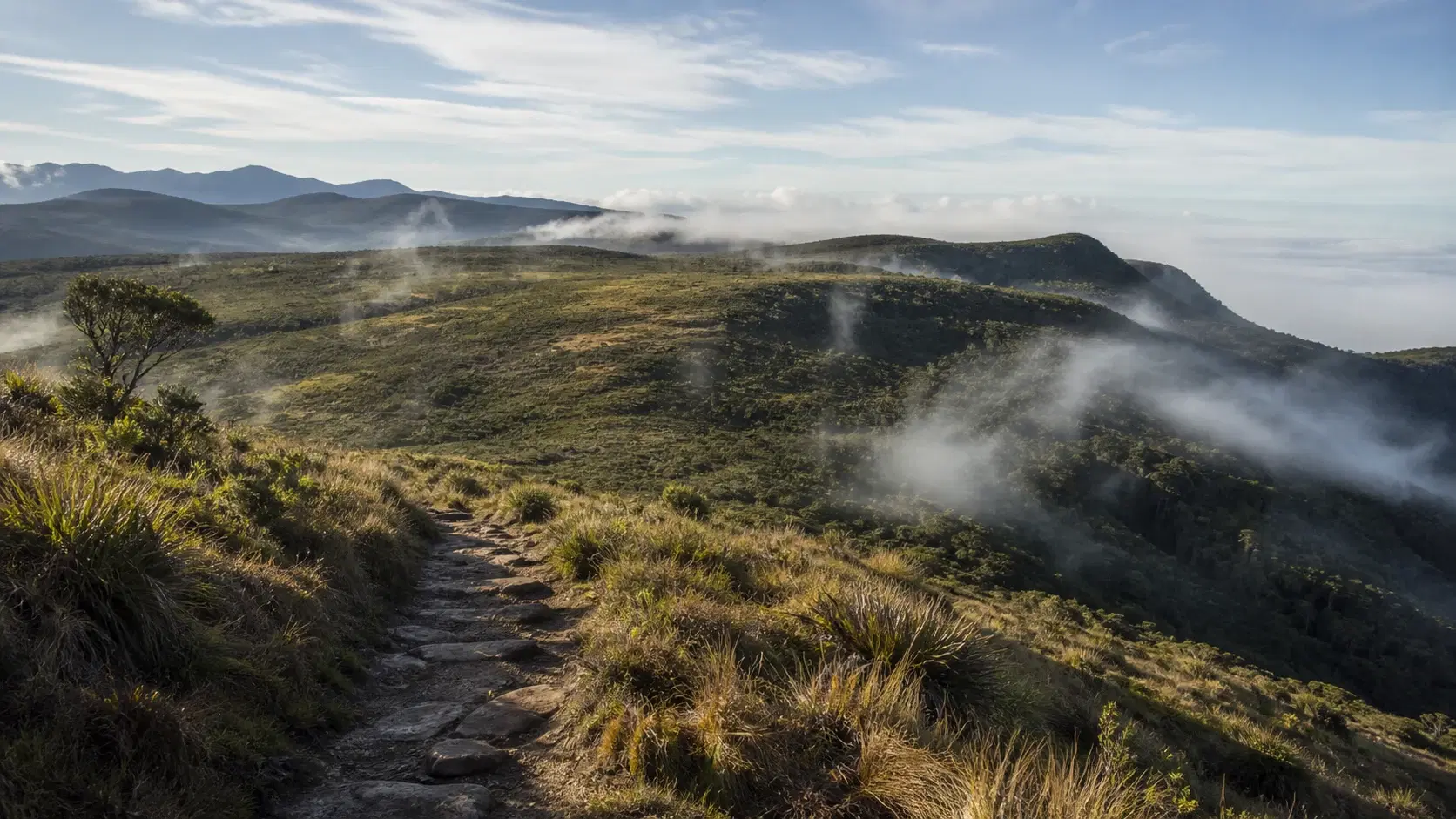
The stage divides cleanly. The first 9.5 km follow wide, straightforward tea trails heading east toward the end of the valley, walking steadily toward the dense forest visible on the horizon. Then you enter the park and the character changes completely.

Once inside, the trail ascends through dense high-elevation rainforest with twists and turns. At around 14.5 km it intersects the main road running through Horton Plains, and a further 500 m along that road brings you to the endpoint at the old Far Inn.

The official 5 hours is a fit hiker's moving time and it is optimistic for 983 m of continuous climbing. We suggest planning 6 to 8 hours, which also gives you the margin the 2 pm cutoff demands.

Note also the regional classification: the stage page gives the region as Haputale while the stage index groups Stage 10 under the Hatton area. This is the third such inconsistency in the cluster, after stages 5 and 9.

15.88 km, 983 m gain, only 216 m lossEssentially a one-way climb from 1,421 m to 2,138 mFirst 9.5 km on wide tea trails, then park forestWell-marked and not technical, just sustainedRegion given as Haputale on the page, Hatton on the index

Dayagama: The Remotest Village on the Trail

The trail organisation describes Dayagama as one of the most remote villages in the tea country, sitting at the far end of the Agarapatana Valley, and notes that very few travellers venture this far.

That is worth pausing on. The Pekoe Trail passes through a great many places tourists do not go, and this is the one its own creators single out as the most remote.

Dayagama sits at around 1,421 m. Stage 9's page gives 1,417 m and Stage 10's gives 1,421 m, a four-metre discrepancy between two official pages that we mention only because it is characteristic of the precision available here.

What that remoteness means practically is that services are limited. Accommodation options are few, and this is emphatically not a place to arrive without a booking. There is a divisional hospital and a police station, both listed as emergency points for this stage.

It also means you are seeing something most visitors to Sri Lanka never do: a working tea village at the end of a valley, without any tourism infrastructure built around it. The trail organisation calls it a deep tea country experience and an authentic, immersive one.

Treat it accordingly. Very few foreign visitors pass through, which makes each one more conspicuous. Greet people, ask before photographing anything, spend money in the village if you can, and do not treat the place as a curiosity.

For anyone walking stages 9 and 10 in sequence, you will spend a night here. That is a genuine opportunity rather than a logistical inconvenience.

The village is also the gateway to the Dayagama entrance of Horton Plains, which is the ticket office you need for this stage. Ask locally about its operating hours; this is exactly the kind of information that is more reliable from a person in the village than from any website.

Described by the trail organisation as one of the most remote tea country villagesSits at around 1,421 m at the far end of the Agarapatana ValleyVery limited accommodation; book in advanceEmergency points include a divisional hospital and police stationAsk locally about the Dayagama park entrance hours

Inside Horton Plains: Cloud Forest, Wildlife and Why It Is Regulated

At around the 9.5 km mark you enter Horton Plains National Park, and the walking changes from tea estate track to dense high-elevation rainforest.

Horton Plains is Sri Lanka's cloud forest plateau, a high montane ecosystem that sits above 2,000 m and supports species found nowhere else. It is part of the Central Highlands UNESCO World Heritage property, alongside the Peak Wilderness and the Knuckles Range.

The official description notes that the forest is alive with wildlife including monkeys, deer, leopards and a host of endemic bird species. Sambar deer are the animal visitors most reliably encounter; leopards are present but very rarely seen.

The park is strictly regulated because of its ecological sensitivity, and the rules are more restrictive than most visitors expect. Plastic is controlled, food is restricted, staying on marked paths is mandatory, and feeding wildlife is prohibited.

Sambar in particular have become habituated in some parts of the park through visitors feeding them, which is bad for the animals and dangerous for people. Do not feed anything, and keep food packed away.

The trail organisation's guidance for this section is specific: it is crucial to travel in a group and, ideally, with the assistance of a national guide to navigate the park responsibly. We would echo that. A park guide understands the rules, the terrain and the wildlife in a way a general driver does not.

Weather on the plateau deserves respect. At over 2,000 m, Horton Plains is genuinely cold by Sri Lankan standards, frequently misted, and subject to fast changes. Temperatures can approach freezing on winter mornings and ground frost occurs. Carry warm layers regardless of how hot Dayagama was at 7 am.

Visibility is the other issue. Mist can close in quickly and the high plateau offers few landmarks. This is not a place to be improvising a route.

The park is also where the Horton Plains to Dayagama old trail runs, listed among the stage's points of interest, which is the historic route this stage broadly follows.

High montane cloud forest, part of a UNESCO World Heritage propertyMonkeys, sambar deer, leopards and endemic birdsStrictly regulated: no feeding wildlife, stay on marked pathsThe trail organisation advises travelling in a group with a national guideGenuinely cold at over 2,000 m; ground frost occurs

Current Safety Position

At the time of writing Stage 10 shows as open with a standard advisory: expect wet and slippery sections after recent rainfall, exercise normal caution and monitor weather updates.

There is no landslide precaution on this stage, which puts it alongside stages 5, 6 and 9 as currently unflagged. Stages 2, 3, 4, 7 and 8 all carry additional warnings.

That is a useful data point but it should not be mistaken for this being an easy or low-risk stage. The risks on Stage 10 are different in kind: they are about cold, altitude, timing and regulation rather than about unstable ground.

The listed emergency points are Dayagama Police Station and Divisional Hospital Dayagama, both at the start of the stage. Once you are climbing toward the park, you are moving away from both.

Inside the park, the relevant authority is the Department of Wildlife Conservation, and park staff are the people to approach in an emergency. This is another argument for the national guide the trail organisation recommends.

Mobile signal is rated poor and the high plateau is not reliable for coverage. Save numbers offline and do not plan around being able to call.

We would not walk this stage alone. The official guidance says it is crucial to travel in a group, which is stronger language than the solo hiking advice on stages 2 to 4, and it applies specifically to the park section.

Check the official stage page and TrailWatch before you go, and separately confirm park conditions with the Department of Wildlife Conservation. National parks close or restrict access for their own reasons, including fire risk in dry periods and weather events, and those closures are not always reflected on the trail organisation's pages.

That last point is worth emphasising. A Pekoe Trail stage showing as open does not guarantee the national park it enters is open.

Currently open with only a standard wet-weather advisoryRisks here are cold, altitude, timing and regulation rather than landslideBoth emergency points are at the start of the stageOfficial guidance says it is crucial to travel in a groupA stage showing open does not mean the national park is open

When to Walk Stage 10

January to April is the strongest window for this stage, consistent with the rest of the highlands, and here it also aligns with the drier conditions that make the high plateau more pleasant.

Horton Plains has its own weather. At over 2,000 m it is cold, frequently misted, and wetter than the surrounding lowland areas even in nominally dry months. Do not assume that a clear morning in Dayagama means a clear afternoon on the plateau.

The famous advice about Horton Plains is to arrive at dawn, because World's End clouds over from mid-morning. That advice applies to a standard park visit from the main entrance and is largely irrelevant to Stage 10, where you arrive in the afternoon by design and are not going to World's End anyway.

What does matter for this stage is that the forest section is more pleasant in dry conditions, the tea trails in the first 9.5 km are exposed and hot in strong sun, and mist on the plateau makes the final section less enjoyable.

Time of day is dictated entirely by the 2 pm park entry cutoff, as covered above. Start between 6 and 7 am.

Temperature planning is unusual on this stage because you experience two climates in one day. Dayagama at 1,421 m in the morning sun can be warm. Horton Plains at 2,138 m in the afternoon mist can be genuinely cold, with temperatures dropping toward single digits and occasional ground frost in the coldest months.

Pack for both. A layering system rather than a single warm garment, and a windproof shell you can put on when you reach the plateau.

Avoid this stage in periods of heavy rain. Not because of a landslide flag, which does not currently exist here, but because a 983 m climb through cloud forest in persistent rain is miserable and the leech pressure in the forest section rises sharply.

Finally, check for park closures. National parks in Sri Lanka can close for weather, fire risk or management reasons, and Horton Plains is no exception.

January to April for the driest plateau conditionsHorton Plains has its own weather; assume colder and mistierStart time is dictated by the 2 pm cutoff, not by the lightYou experience two climates in one day; layer accordinglyCheck for national park closures separately from the trail status

Preparation and What to Carry

Stage 10 requires more careful packing than any other stage in the first ten, because of the altitude gain, the temperature range and the park regulations.

Water: at least three litres per person. There is no resupply after Dayagama and you cannot rely on buying anything inside the park.

Food: a full day's worth, but note that the park has restrictions on what you can bring in and how you manage it. Pack food in reusable containers rather than single-use plastic, keep it sealed, and carry every scrap of waste out.

Warm layers are the item people most often get wrong. A fleece or insulated mid-layer plus a windproof shell is the minimum for arriving at 2,138 m in the afternoon. Sri Lanka does not feel like a country where you need this, right up until you are standing on the plateau in the mist.

Sun protection for the first 9.5 km on the exposed tea trails, which is the opposite problem to the one you will have later.

Footwear: trail shoes or light boots with grip. The forest section is damp and rooty.

Walking poles help on a sustained 983 m climb more than most people expect.

Leech socks if there has been rain. High-elevation rainforest in wet conditions is prime leech territory.

Documents: your park ticket, your trail pass loaded in the app, and identification. Park staff may want to see your ticket.

Navigation: download the stage route and offline maps before leaving Dayagama.

Then the standard set: first aid kit, power bank, headtorch, emergency numbers saved offline, and cash in small denominations for Dayagama.

One thing to leave behind: single-use plastic. Horton Plains has restrictions and it is bad practice regardless.

At least three litres of water; no resupply after DayagamaWarm mid-layer and windproof shell for the plateauSun protection for the exposed first 9.5 kmPark ticket, trail pass and ID all neededAvoid single-use plastic; the park restricts it

Walking Stage 10 Responsibly

This stage has two distinct responsibility contexts: a remote working village and estates for the first 9.5 km, and a strictly regulated national park after that.

In Dayagama and on the estate trails, the ordinary principles apply. Very few visitors come this far, which makes each one more visible. Greet people, ask before photographing anyone or their property, never photograph children, stay on marked paths through the tea, and do not pick leaves.

Spend money in the village. Dayagama sees very little tourism income and a meal, a shop purchase or a guide's fee has proportionally more effect here than in Hatton or Nuwara Eliya.

Inside the park, the rules are stricter and they are not suggestions. Stay on marked paths without exception. The trail organisation's own note about the park being strictly regulated due to its ecological sensitivity is accurate.

Do not feed any animal, ever, for any reason. Sambar in Horton Plains have been habituated by visitor feeding and it harms them. Keep food sealed and packed away when not eating.

Carry out every piece of waste, including organic waste like fruit peel. High montane ecosystems break material down very slowly and introduced organic matter affects them.

Do not take anything: no plants, no flowers, no stones. Endemic species in this park exist nowhere else on earth.

Keep noise moderate. This is a wildlife area and quiet groups see more and disturb less.

Follow park staff instructions without argument. They are managing a UNESCO-listed ecosystem with limited resources and visitor compliance is most of what makes that possible.

The trail organisation recommends a national guide for the park section. Beyond safety, a guide keeps you compliant with rules you may not know exist, and guiding fees support the local economy.

No drones. National parks in Sri Lanka restrict them and Horton Plains is not a place to test that.

Dayagama sees very little tourism; spend money thereStay on marked paths inside the park without exceptionNever feed wildlife; sambar have been habituated by visitorsCarry out all waste including fruit peelNo drones, no collecting, follow park staff instructions

Should You Walk Stage 10? An Honest Verdict

Stage 10 is the most rewarding stage in the Hatton cluster and the one most likely to go wrong for reasons unrelated to your fitness.

Walk Stage 10 if you are a fit hiker comfortable with a sustained 983 m climb, walking in a group, able to start at 6 or 7 am, and willing to do the planning that the park ticket and driver logistics require. For that person this is a genuinely special day: climbing out of the remotest corner of the tea country into a UNESCO-listed cloud forest.

Walk it if you want Horton Plains without the crowds. The standard park experience is a dawn convoy of vans to the main entrance and a busy World's End loop. Arriving on foot through the forest from Dayagama is a completely different way to reach the same plateau.

Walk it if you have already walked several stages and want the trail's high point in the first half of the route.

Do not walk it without the park ticket sorted in advance. This is the single most common way to fail on this stage, and walking 9.5 km to a boundary you cannot cross is a wasted day.

Do not walk it with a late start. The 2 pm cutoff is enforced and there is no negotiating at the gate.

Do not walk it with an uncoordinated driver. Fifteen kilometres on foot is sixty-five by road, and a driver who does not understand that will not be there.

Do not walk it alone. The official guidance says it is crucial to travel in a group, which is stronger language than appears on any other stage in the cluster.

Do not walk it the day after Stage 9 without thinking hard about it. A Hard-graded 17 km day followed by a 983 m climb starting at 6 am is a demanding pairing.

Do not walk it expecting to add World's End. In practice you will arrive too tired and too late in the day, and the viewpoint will be clouded over.

Do not walk it if the cost is a problem. Roughly USD 55 for a single stage, once the park fee is added to the trail pass, makes this the most expensive day on the Pekoe Trail by a wide margin. That is a legitimate reason to choose a different stage, and Stage 8 or Stage 9 will give you a fine day for a tenth of the outlay.

For the traveller who plans it properly, though, this is the stage the first half of the Pekoe Trail has been building toward.

The most rewarding stage in the cluster and the easiest to get wrongA completely different way to reach Horton PlainsSort the ticket and the driver before anything elseDo not walk it alone or with a late startAt roughly USD 55 it is by far the most expensive stage

Travel Tips

  • Sort the Horton Plains park ticket before you start walking, not at the boundary
  • Confirm current park fees with the Department of Wildlife Conservation; published figures age quickly
  • Entry from this stage is not possible after 2 pm; start between 6 and 7 am
  • Stay in Dayagama the night before rather than transferring pre-dawn
  • Your driver faces a 65 km road journey to cover 15 km of trail; coordinate explicitly
  • Arrange park entry for your driver's vehicle as well as for yourself
  • Consider a rest day between Stage 9 and Stage 10
  • Carry a warm mid-layer and windproof shell; the plateau is far colder than the start
  • Carry at least three litres of water; there is no resupply after Dayagama
  • Do not plan to add World's End on the same day; it will be clouded and you will be tired
  • Avoid single-use plastic; the park restricts it
  • Never feed wildlife; sambar in the park have been habituated by visitors
  • Hire a national guide for the park section as the trail organisation recommends
  • Check separately for national park closures; a stage showing open does not mean the park is
  • Book Dayagama accommodation well in advance; options are very limited

Frequently Asked Questions

How much does Pekoe Trail Stage 10 cost?

You need both a Pekoe Trail pass and a Horton Plains National Park entrance ticket. The trail pass is USD 10 per stage for foreign visitors. The trail organisation gives the park fee as approximately USD 45, subject to exchange rate fluctuations. That makes Stage 10 by far the most expensive stage on the trail. Confirm current park rates with the Department of Wildlife Conservation.

Where do I buy the Horton Plains ticket?

At the park entrance, either the Dayagama entrance or the Ohiya entrance, before entering the park. You cannot buy one inside the park and it is not available through the Pekoe Trail app. Since you start walking in Dayagama and only reach the boundary at around 9.5 km, sort this before you set off.

What is the 2 pm cutoff?

The trail organisation states that entry to the park from this stage is not possible after 2 pm. With the park boundary at around 9.5 km after a sustained climb, that means starting between 6 and 7 am to have real margin. The cutoff is enforced.

How long is Stage 10 and how hard is it?

It is 15.88 km with 983 m of elevation gain and only 216 m of loss, climbing from around 1,421 m at Dayagama to around 2,138 m at Horton Plains. It is graded Difficult in both directions. The official duration is 5 hours; we suggest planning 6 to 8. There is no technical difficulty, just sustained climbing.

Why is the driver logistics such a problem?

The endpoint at the old Far Inn is about 15 km from Dayagama on foot but around 65 km by road, because the road loops back through Nuwara Eliya. The trail organisation advises ensuring your driver is well coordinated and notes they will likely arrive just before you do. Your driver also needs park entry arrangements for the vehicle.

What else does the park ticket cover?

The trail organisation states the fee also allows you to walk the Baker's Falls trail, the World's End trail loop, and to summit Kirigalpotha, Sri Lanka's second highest peak, and Thotupola Kanda. In practice you will be too tired and arriving too late in the day to use much of that on a Stage 10 day.

Can I do World's End after finishing Stage 10?

Technically the ticket allows it, but realistically no. The World's End loop is around 9 km on its own, making a 25 km day at altitude, and the viewpoint is usually clouded over from mid-morning onward. A separate dawn visit is the better plan, though that means paying park entry again.

Can I hike Stage 10 alone?

The trail organisation's guidance says it is crucial to travel in a group and ideally with a national guide to navigate the park responsibly. That is stronger language than appears on any other stage in this cluster. We would not walk it alone.

Is Stage 10 safe to hike right now?

At the time of writing it shows as open with only a standard advisory about wet and slippery sections after rainfall, and no landslide precaution. The risks here are cold, altitude, timing and regulation rather than unstable ground. Check the stage page and TrailWatch, and separately confirm the national park is open.

How cold does it get at Horton Plains?

At over 2,000 m it is genuinely cold by Sri Lankan standards, frequently misted, and subject to fast changes. Temperatures can approach freezing on winter mornings and ground frost occurs. Carry a warm mid-layer and a windproof shell regardless of how warm Dayagama was when you started.

What wildlife might I see?

The official description notes monkeys, deer, leopards and a host of endemic bird species. Sambar deer are the animal visitors most reliably encounter. Leopards are present but very rarely seen. Never feed anything; sambar in the park have been habituated by visitor feeding, which harms them and creates risk for people.

Where should I stay for Stage 10?

Dayagama, the night before. It is remote with very limited accommodation, so book well in advance, but a pre-dawn transfer along hill country roads to make a 6 am start is worse. If you are walking Stage 9 first, you will finish in Dayagama anyway.

Should I walk Stage 9 and Stage 10 on consecutive days?

Think carefully. Stage 9 is graded Hard and runs around 17 km, finishing in Dayagama. Following it with a 983 m climb starting at 6 am is demanding. A rest day between them is worth serious consideration, and Dayagama is an interesting enough village to spend one in.

Is there a cheaper way to experience this stage?

Yes. Walk the first section as an out-and-back from Dayagama along the wide tea trails toward the forest, turning back before the park boundary at around 9.5 km. That gives roughly 15 km of remote Agarapatana Valley walking for the price of the trail pass alone, and you can save the park fee for a dedicated dawn visit to World's End.

Which region is Stage 10 in?

The stage page lists the region as Haputale while the stage index groups it under the Hatton area. This is the third such inconsistency in this cluster, after Stage 5 and Stage 9, so the index's five-stage Hatton grouping actually contains stages the organisation itself assigns to three different regions.

Reader notes

Join the conversation

Share your question, tip, or travel experience for this guide.

Comments

0 comments

Loading...

Ready to turn inspiration into a Sri Lanka trip?

Use LankaTrip to plan your journey, connect with local guides, and make this itinerary a reality.

Need help planning?

Plan your Sri Lanka adventure

Plan my trip