
LankaTrip Insights

30 min read

Pekoe Trail Stage 5 in 2026: Pundaluoya to Watagoda, the Only Kandy-Cluster Stage With No Landslide Warning

Stage 5 runs 14.31 km from Pundaluoya to Watagoda, climbing 780 m and losing only 356 m. It is graded Moderate, it is the only stage in the Kandy cluster without a landslide precaution attached, and it ends at a station on the closed section of the Main Line.

Back to blog
Pekoe Trail Stage 5 in 2026: Pundaluoya to Watagoda, the Only Kandy-Cluster Stage With No Landslide Warning

After Stage 4, which climbs 1,195 m and currently carries a landslide precaution, Stage 5 arrives like an apology.

It is 14.31 km. It gains 780 m and loses only 356 m, which is the cleanest climbing profile in the whole cluster. It is graded Moderate rather than Difficult. And at the time of writing it is the only one of the first five stages that is not flagged with a precaution about slippery terrain and landslide risk, carrying instead the standard advisory about wet sections after rainfall that applies almost everywhere in the highlands.

That combination makes it, right now, the most straightforwardly walkable stage of the first five for anyone who is not an experienced mountain hiker. If you have limited time in this part of the country and you want one good day on the trail without a safety briefing attached, this is a strong candidate.

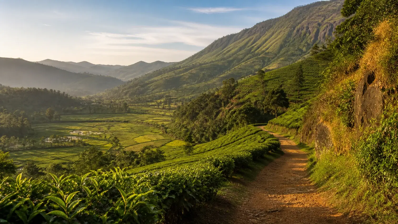
The walking itself is varied in a way the harder stages are not. Paddy fields, river crossings, a waterfall, a quiet valley road with almost no traffic, village homes, a Buddhist temple, and then the climb into tea country proper.

The visual centrepiece is unusual: a wall of rock and forest that forms the boundary of the Pundaluoya valley, steep enough that the trail organisation reaches for a Game of Thrones comparison to describe it. On top of it sits one of the more photogenic tea estates in the region.

There is one practical complication that most published guides have not caught up with, and it is significant. The stage officially ends at Watagoda Train Station. Watagoda sits on the stretch of the Main Line that has been closed for repairs since Cyclone Ditwah. A finish point chosen because it was a convenient railway station is currently a station with no trains.

This guide covers the route, the Dimbula context, the trail-hours question, and how to plan the end of your day given the rail situation.

Quick Summary

  • Stage 5 runs 14.31 km from Pundaluoya to Watagoda, gaining 780 m and losing only 356 m, with a maximum elevation of around 1,352 m
  • It is graded Moderate in both directions, making it the second gentlest stage in the cluster after Stage 1
  • It is currently the only stage among the first five with no landslide precaution attached, carrying just the standard wet-weather advisory
  • The official average duration is 4 hours 30 minutes; we suggest planning 5 to 7 hours elapsed
  • The stage page lists the region as Hatton, even though the stage index groups it under the Kandy area
  • The scenic highlight is a rock and forest wall forming the boundary of the Pundaluoya valley, with a photogenic tea estate on top of it
  • It marks the entry into Dimbula, one of the earliest and most historically significant tea districts in Sri Lanka
  • The official end point is Watagoda Train Station, which currently has no train service due to the Main Line closure

The Numbers, and Why This Stage Feels Easier Than It Reads

The official figures for Stage 5: length 14.31 km, elevation gain 780 m, elevation loss 356 m, maximum elevation 1,352 m, average duration 4 hours 30 minutes, region Hatton, people interactions High, difficulty Moderate in both directions.

The number that shapes the day is the loss figure. At 356 m, Stage 5 has by far the least descent of the first five stages. Stage 3 loses 1,020 m. Stage 4 loses 1,126 m. Stage 5 loses less than a third of either.

That matters more than most hikers expect. Descent is what causes knee pain, quadriceps fatigue and toenail damage, and it is why net-downhill stages leave people limping the following morning despite feeling fine at the time. Stage 5 mostly climbs, and climbing is tiring in a way that recovers overnight.

The gain figure of 780 m is not trivial, and it is more than Stage 3's 762 m. But it is delivered gently. The official route description explicitly notes that after the 5.7 km mark the path heads uphill at a gentle, manageable gradient, and the only sharp section is a short final push of about 2 km into Watagoda.

This is the difference between a stage that is physically demanding and one that is technically demanding. Stage 5 is neither, particularly. It is a long, pleasant, mostly uphill walk.

The official duration of 4 hours 30 minutes is more credible here than on Stage 4, where the same figure is attached to 1,195 m of climbing. For Stage 5 we would still add time for stops, photographs and the river crossings, and suggest planning 5 to 7 hours elapsed.

One oddity worth noting for anyone reading the official material closely: the stage page lists the region as Hatton, while the stage index groups Stage 5 under the Kandy area alongside stages 1 to 4. Both are official. It is a classification inconsistency rather than a practical problem, but it explains why different sources place this stage in different regions.

Geographically, the Hatton designation makes more sense. This stage is where the trail leaves the Kandy hinterland behind and enters the Dimbula tea country that defines the Hatton and Nuwara Eliya region.

14.31 km, 780 m gain, only 356 m lossMaximum elevation around 1,352 mLeast descent of the first five stages by a wide marginGraded Moderate; gradient described as gentle and manageableOfficial 4h30; plan 5 to 7 hours elapsedListed as Hatton region on the stage page, Kandy on the index

The Safety Position, and Why This Stage Stands Out

At the time of writing, Stage 5 shows as open with a standard advisory: expect wet and slippery sections after recent rainfall, exercise normal caution and monitor weather updates.

That is materially different from what stages 2, 3 and 4 currently carry. Those three are flagged with a precaution about slippery terrain and localised landslide risk following recent rainfall, with explicit advice to avoid solo hiking. Stage 2 additionally has an amber status attached to a defined section damaged by landslides on protected forest land.

Stage 5 has none of that. Its advisory is the ordinary highland caution that applies to walking anywhere in this landscape after rain.

This is the single strongest practical argument for choosing Stage 5 if you are picking one stage from the cluster to walk in 2026. It is the only one where the current guidance does not include a landslide warning or a recommendation against walking alone.

We want to be careful not to overstate it. Open with a wet-weather advisory does not mean risk-free. Estate roads and village paths get genuinely slippery, the highlands produce sudden afternoon storms, and mobile signal along this stage is rated poor like everywhere else on the trail.

It also does not mean permanent. Stage statuses change. A single heavy rainfall event can move a stage from a standard advisory to a precaution within days, and the trail organisation updates these as conditions warrant. Check the official stage page and the TrailWatch app before you set out rather than relying on this article.

The listed emergency points for Stage 5 are the PMCU at Pundalu Oya and Divisional Hospital North Medakumbura. Save those before you start, since signal is unreliable along the route.

As with any stage, tell your accommodation your route and expected finish time. On a Moderate stage in populated country this is a small precaution rather than a serious one, but it costs nothing.

Currently open with only a standard wet-weather advisoryThe only stage of the first five without a landslide precautionNo current recommendation against solo hiking on this stageStatuses change; check the stage page and TrailWatch before you goEmergency points: PMCU Pundalu Oya and Divisional Hospital North Medakumbura

The Special Trail Hours Question

The trail organisation's stage index flags Stage 5 with a note reading special trail hours. Stages 6, 7, 8, 10 and 11 carry the same flag.

The organisation's general guidance explains what this means in principle: most stages are open from 6 am to 6 pm, and some are open for shorter periods, particularly in wildlife corridors and protected areas.

What it does not do, at least on the Stage 5 page itself, is tell you what those hours actually are. The flag appears on the index. The stage page lists the trail information, points of interest, emergency points and the standard advisory, but no specific opening window.

We are flagging this rather than guessing, because guessing at access hours is exactly the kind of thing that gets a hiker turned back at a gate or caught somewhere they should not be at dusk.

The practical implications are straightforward. Do not plan a pre-dawn start on this stage without confirming. Do not plan to still be walking at last light. And check the official app, which carries stage-level information that the website does not always mirror.

If you are walking with a local guide, ask them directly. This is precisely the kind of on-the-ground operational detail that guides know and websites lag on.

For a stage with an official duration of 4 hours 30 minutes and our suggested 5 to 7 hours elapsed, a 7 am start comfortably fits inside a 6 am to 6 pm window with hours to spare. The hours question is unlikely to constrain a normally planned day. It matters if you were considering a sunrise start or a late afternoon attempt.

The broader lesson applies across the whole trail: the official app and TrailWatch carry more current and more granular information than the website, and both are worth having before you walk any stage.

Stage 5 is flagged with special trail hours on the stage indexThe stage page does not specify what those hours areGeneral guidance: most stages open 6 am to 6 pm, some shorterDo not plan a pre-dawn start without confirmingThe official app carries more granular information than the website

The Route: Pundaluoya to the Valley Road

The stage begins just before Pundaluoya town near a river crossing, which the trail organisation specifically identifies as an easy landmark for meeting guides or drivers. That is a genuinely useful detail and it makes the logistics of this stage simpler than most.

About 100 m ahead, a small road to the right leads through a cluster of village homes. Passing through the town you walk by the local mosque, the police station, and a row of houses along the village edge.

This is an unusually intimate opening for a Pekoe Trail stage. You are not walking through a landscape so much as through somebody's neighbourhood, and normal courtesy applies from the first few hundred metres.

The trail then zigzags scenically for over a kilometre across paddy fields and light forest, crossing a river along the way. The emerald green of hill country paddy is one of the more underrated sights in Sri Lanka and it photographs beautifully in morning light.

At around 1.9 km the trail merges onto a secondary road descending into the valley. Traffic here is sparse, and the walk remains peaceful despite being on tarmac. This is the kind of quiet rural road that would be unremarkable to a Sri Lankan and is genuinely lovely to walk if you have come from somewhere with busier roads.

You follow this road until the 5.7 km mark, where a right turn takes you onto a new track. From this point the path heads uphill at what the official description calls a gentle, manageable gradient, and it continues climbing all the way to the end of the stage.

The next 4 km follow a picturesque village road past a Buddhist temple and through more paddy fields and village homes. The trail organisation describes this section as a prelude to the tea landscapes ahead, which is fair; it is pleasant rather than dramatic.

Along the way, keep an eye out for a vintage red telephone box beside the route. It is an incongruous colonial-era survival in the middle of hill country paddy, and it is one of the more photographed objects on this stage.

Wildflowers grow along the roadsides through this section, and there are patches of paddy suitable for a short rest if you need one.

Starts at a river crossing just before Pundaluoya townPasses the local mosque, police station and village homesZigzag over paddy fields and light forest with a river crossingQuiet secondary road from 1.9 km to 5.7 kmGentle sustained climb begins at 5.7 kmA vintage red telephone box beside the route

The Route: The Dimbula Wall and the Climb to Watagoda

At the 9.6 km mark the trail veers left and you are back on tea estate roads. This is the moment the stage changes character.

To the left is the view the stage is built around: the Dimbula Hills, and a dramatic wall of rock and forest that forms the boundary of the Pundaluoya valley. The trail organisation compares it to the wall in Game of Thrones, which is the kind of reference that usually oversells a landscape and here is not unreasonable. It looks close to insurmountable.

On top of that rock face sits one of the most photogenic tea estates in the region, with views from higher elevations that this stage only hints at.

This is also the point where you are genuinely entering Sri Lanka's tea country in the historical sense. Dimbula is one of the earliest districts to be planted and remains one of the most significant tea-growing regions in the country. Stages 1 to 4 pass through tea estates; Stage 5 is where you cross into the district whose name appears on tea packaging worldwide.

At around 10.5 km you pass the Elpitiya Elders Home, leaving it on your right, and continue along estate trails. Shortly afterwards a tea factory appears on the left.

Then comes the final push: a short but demanding climb of about 2 km to Watagoda. After 12 km of gentle gradient this feels steeper than it is, and it is the only part of the stage where the Moderate grading is being earned.

At the 12.7 km mark the trail crosses a small dam and navigates three quick switchbacks before descending slightly into Watagoda Town.

Watagoda is a lively little village dotted with shops and kades, the small local eateries and general stores that are one of the pleasures of finishing a hike in a Sri Lankan town rather than at a car park. It is a good place to eat, and buying here puts money directly into a community on the route.

The Watagoda Train Station marks the official conclusion of the stage.

Back on tea estate roads at 9.6 kmThe Dimbula rock and forest wall bounding the valleyEntry into the historic Dimbula tea districtElpitiya Elders Home at 10.5 km, then a tea factoryA short steep 2 km climb to finishSmall dam and three switchbacks at 12.7 km

The Watagoda Station Problem in 2026

This is the part of Stage 5 that almost no currently published guide addresses, and it directly affects how you plan the end of your day.

The stage was designed to finish at Watagoda Train Station, which is an elegant piece of route planning. A railway station is a natural terminus: you finish a hike, wait on a platform, and travel onward without needing a vehicle to have driven up a mountain to collect you.

Watagoda sits on the hill country Main Line between Hatton and Nanu Oya. That stretch falls inside the Rambukkana to Nanu Oya section, which has been closed for repairs since Cyclone Ditwah damaged the line in late 2025. Reopening is currently expected around January 2027.

Trains are running Colombo to Rambukkana at the lower end and Nanu Oya to Ella and Badulla at the upper end. The section in between, which includes Kandy, Hatton, Kotagala and Watagoda, is the part under repair.

In practical terms that means arriving at Watagoda station at the end of Stage 5 and expecting to catch a train onward is not currently a plan. You need road transport arranged.

We want to be appropriately careful here. Railway restoration timelines move, sometimes faster than announced and sometimes slower, and partial reopenings happen. Our own reporting on the hill country line is that the Nanu Oya to Ella stretch came back into service earlier this year. Confirm the current position with Sri Lanka Railways or locally before you build your day around it.

What we would not do is arrive at the station on the strength of a guide written in 2024 that says you can catch a train from here.

The upside is that Watagoda Town is on a road and is not remote. Arranging a driver to collect you is straightforward, and buses serve the area. This is a logistical adjustment rather than a serious problem.

If the line has reopened by the time you read this, Stage 5 becomes one of the best-connected stages on the entire trail, and finishing a walk by stepping onto a hill country train is a genuinely lovely way to end a day. It is worth checking precisely because the upside is so good.

The stage officially ends at Watagoda Train StationWatagoda sits on the closed Rambukkana to Nanu Oya sectionLine damaged by Cyclone Ditwah in late 2025Reopening currently expected around January 2027Arrange road transport and confirm the current position before you go

Dimbula: Why This Tea District Matters

Most visitors to Sri Lanka encounter the word Dimbula on a tea packet without knowing it refers to a specific place with a specific climate, and Stage 5 is where you walk into it.

Sri Lanka's tea regions are defined largely by elevation and by which monsoon reaches them. Dimbula sits in the high-grown category on the western slopes of the Central Highlands, which means it catches the southwest monsoon directly and then experiences a cold, dry period afterwards.

That dry spell is what produces the character the district is known for. Tea plucked during the driest weeks of the western quality season is regarded as among the finest the country produces, and the effect of climate on flavour is more pronounced here than most casual tea drinkers realise.

Dimbula was also one of the earliest districts to be planted, which matters historically. After James Taylor proved the crop at Loolecondera in 1867, the expansion outward into districts like Dimbula was what turned an experiment into an industry, and it is the reason the roads you walked on stages 3 and 4 were cut in the first place.

Walking stages 1 to 5 in sequence therefore traces something coherent: from the Ceylon Tea Museum at Hanthana, to the estate where tea was first planted, over the colonial cart roads built to move it, and into the district where the industry scaled.

The estates you pass on this stage are working operations. The tea factory near 10.5 km is a functioning processing site, not a visitor attraction, and should be treated accordingly unless you have arranged a visit.

If you want to understand tea properly rather than just walk past it, this is a good stage on which to have a guide. The difference between what you see and what is happening is substantial, and a plucker's basket, a weighing station and a withering loft mean very little without explanation.

It is also worth noting what the tea industry is socially. The estate communities across these hills are largely descended from Indian Tamil labour recruited during the colonial expansion, and their history in Sri Lanka has been difficult. The landscape's beauty and that history are not separable.

Dimbula is a high-grown district on the western slopesThe dry period after the southwest monsoon defines its characterOne of the earliest districts planted after LooleconderaStages 1 to 5 trace the industry's origin and expansionEstates and factories on the route are working operations

Transport at Both Ends

The start of Stage 5 is one of the better-designed trailheads on the trail. It sits just before Pundaluoya town near a river crossing, which the trail organisation explicitly describes as an easy-to-spot landmark ideal for meeting guides or drivers.

That solves the single most common problem with point-to-point stage hikes, which is agreeing a drop-off point that both you and your driver can identify without signal.

Pundaluoya itself is a small hill country village reached by road. If you have just walked Stage 4, you finished here. If you are coming fresh, the approach is from the Gampola to Nuwara Eliya road via Tawalantenne, or from the Hatton direction.

Local buses serve Pundaluoya, though schedules are informal. As with the rest of the cluster, a driver for the day is the more reliable arrangement.

The finish at Watagoda is on a road and in a functioning town with shops and kades, which makes it a comfortable place to wait for a pickup. This is a considerably better endpoint than a remote estate gate.

Given the current rail closure, arrange road transport from Watagoda rather than assuming a train. Confirm the pickup point and a realistic time window before you start, since signal along the route is poor.

If you are continuing to Stage 6, it runs from Watagoda to Kotagala and is graded Easy at 14.97 km, so finishing Stage 5 in Watagoda town positions you well for the following morning.

For the wider 2026 picture: reaching the hill country at all currently means road travel for the Kandy and Hatton stretch, since the Rambukkana to Nanu Oya section of the Main Line is closed. Build longer transfer times into your itinerary than guidebooks assume, and read our dedicated guide to what is and is not running before locking in dates.

Start is at a river crossing, an easy landmark for driversPundaluoya is reached by road from Tawalantenne or HattonWatagoda is a functioning town, a comfortable place to waitArrange road transport from the finish, not a trainStage 6 continues from Watagoda and is graded Easy

When to Walk Stage 5

January to April remains the strongest window, as across the cluster, and it gives the best odds of clear views toward the Dimbula Hills and the rock wall.

Stage 5 handles imperfect weather better than its neighbours, though. Much of the route is on village roads, secondary road and estate track rather than steep exposed mountainside, and the total descent is small, so wet conditions are less consequential here than on a stage that loses over a kilometre of vertical.

Rain also improves parts of it. The waterfall near the Pundal Oya crossing is more impressive with water in it, the paddy fields are greener, and the whole valley section looks better under cloud than a parched landscape does.

The southwest monsoon, roughly May to September, brings the wetter weather to this side of the highlands, and Dimbula catches it directly by virtue of its position on the western slopes. That is the season this district's character is built around, so there is something appropriate about seeing it wet.

What we would still avoid is walking during or immediately after genuinely heavy rainfall. The standard advisory about wet and slippery sections is not decorative, estate roads become treacherous, and leech pressure rises sharply.

Time of day follows the usual highland pattern. Mist builds through the afternoon and the Dimbula wall view at 9.6 km deserves clear air. A 7:00 am start puts you there comfortably in the morning.

That start time also sits safely inside the standard 6 am to 6 pm window in case the unspecified special trail hours turn out to be restrictive.

Given our 5 to 7 hour estimate, this is one of the few stages in the cluster where a slightly later start is genuinely survivable. It is still not advisable, but if you sleep through an alarm on Stage 5 the day is recoverable in a way it would not be on Stage 3 or 4.

January to April for the clearest Dimbula viewsHandles wet weather better than the harder neighbouring stagesRain improves the waterfall and the paddy sectionsAvoid walking during or right after heavy rainfallA 7:00 am start is comfortable and stays inside standard trail hours

Preparation and What to Carry

Stage 5 is the least demanding stage in the cluster after Stage 1, and the packing list reflects that. You are preparing for a long pleasant day rather than a mountain expedition.

Carry at least two and a half litres of water per person. The people-interaction rating is High and you pass through Pundaluoya town at the start and villages along the way, so some resupply is realistic, but do not plan around a shop being open at a particular kilometre.

There are river crossings on this stage. They are described as crossable rather than technical, but wet feet are a real possibility and quick-drying socks are worth having. Do not attempt any crossing that looks stronger than expected after rain.

Footwear should be trail shoes with grip. The mix of paddy edges, village road, estate track and one short steep climb does not demand boots, but smooth-soled trainers will be unpleasant on wet tarmac and estate roads.

Sun protection matters on the road and paddy sections, which have limited shade. Hat, sunscreen, sunglasses.

Walking poles are less necessary here than on stages 3 and 4 because of the small descent figure, though they help on the final 2 km climb if you use them habitually.

Leech socks if there has been rain, particularly for the light forest section early in the stage.

Small denomination cash for the kades in Watagoda at the finish and any village shops along the way. This is a stage where buying locally is easy and worth doing.

Then the standard set: offline maps and the stage route downloaded, power bank, first aid kit, packable rain layer, emergency numbers saved offline, and your trail pass loaded in the app before you leave signal.

At least two and a half litres of water per personQuick-drying socks for the river crossingsTrail shoes with grip rather than bootsSun protection for the road and paddy sectionsCash for the kades in Watagoda at the finish

The Trail Pass

The Pekoe Trail pass applies to Stage 5 as to every other stage. Foreign visitors pay USD 10 per stage, Sri Lankan residents pay LKR 600 per stage, and children under 12 are free. Members of the trail organisation receive unlimited passes.

Buy it through the official Pekoe Trail app or the web portal, using the same email for both. Do this the night before rather than at the trailhead, since signal in the area is poor.

The reasoning across the trail is the same. The route crosses public land, private tea estates and village land, and access exists because landowners agreed to it. The donor funding that originally built the trail has ended, and the organisation states that landowners may restrict access to hikers who cannot show a valid pass. Revenue funds maintenance, signage, the app, safety updates and community programmes.

On Stage 5 this feels particularly direct. The route passes through a working village at the start, across paddy that belongs to somebody, past private homes, and onto estate roads. Almost every metre of this stage is somebody's land or somebody's neighbourhood.

There is no checkpoint and nobody will scan you onto the trail. Buy the pass anyway.

Certain stages elsewhere on the trail require additional tickets or permits for protected areas and private land on top of the pass. Stage 5 does not appear to carry that complication, but the special trail hours flag is a reminder that access conditions here are not identical to a public footpath.

Group size is capped at 20 people under trail policy. Unlike stages 2, 3 and 4, there is currently no advice against solo hiking on Stage 5, which makes it the most realistic option in the cluster for a confident solo walker.

If you are planning four or more stages, membership is worth costing out against individual passes.

USD 10 per stage for foreign visitors, LKR 600 for residentsUnder-12s free; members receive unlimited passesBuy the night before; trailhead signal is poorAlmost the whole stage crosses village or estate landCurrently the most realistic cluster stage for a solo walker

Walking Stage 5 Responsibly

More than any other stage in the cluster, this one walks through people's daily lives. The route passes a mosque, a police station, rows of village homes, a Buddhist temple, paddy fields and an elders' home. The people-interaction rating is High and it is earned.

The operating standard is ordinary neighbourly courtesy rather than wilderness ethics. Greet people. Keep your voice down passing homes early in the morning. Do not photograph anyone, their house or their land without asking, and accept no as an answer.

Paddy fields are crops, not scenery. Do not walk into them, do not stand on the bunds between plots for photographs, and stay on the path. A rice bund is a piece of working water management and damaging it has real consequences for the farmer.

At the mosque, the Buddhist temple and any kovil along the route: cover shoulders and knees, remove shoes where indicated, do not photograph during prayer or observances, and do not enter simply to look around unless it is clearly open to visitors.

The Elpitiya Elders Home is a residential care facility. Walk past it. Do not photograph it or its residents.

On the estate sections, stay on marked paths, do not cut between tea rows, and do not pick leaves. The tea factory near 10.5 km is a working processing site.

Do not swim at the river crossings or waterfall if water levels are high, and do not leave anything behind if you do stop at the water. These are catchments serving communities downstream.

Spend money in Watagoda at the finish. The kades and shops there are exactly the kind of small local businesses the trail was created to benefit, and a meal at the end of a walk is the easiest possible way to contribute.

Carry out everything you carry in, and pick up litter you find where you can. Drones need permission and should not be flown over homes or the elders' home at all.

This stage walks through people's neighbourhoodsDo not enter paddy fields or stand on the bundsCover up at the mosque, temple and kovilsWalk past the elders' home without photographing itEat and spend in Watagoda at the finish

Should You Walk Stage 5? An Honest Verdict

If you are picking exactly one stage from the first five to walk in 2026, and you are not an experienced mountain hiker, this is our recommendation.

The reasoning is not that Stage 5 is the most spectacular. Stage 4 has the better single viewpoint and Stage 3 has the more interesting history underfoot. The reasoning is that Stage 5 is the only one currently carrying no landslide precaution, the only one where solo walking is not advised against, and the one with the gentlest profile and the friendliest logistics at both ends.

Walk it if you want a full, varied, genuinely pleasant day on foot without a safety briefing attached. Paddy, rivers, a waterfall, quiet valley road, village life, and then the Dimbula wall and the climb into tea country. It is a good day out by any standard.

Walk it if you are a confident solo hiker. Stages 2, 3 and 4 all currently carry advice against walking alone. Stage 5 does not.

Walk it if you found Stage 1 comfortable and want something a step up without the jump to Difficult.

Do not walk it expecting drama. There is no summit here, no exposure, no single moment that will define the day the way the Stellenberg Pass does on Stage 3. The rock wall is impressive and the rest is a lovely, gentle accumulation. If you want to be astonished, this is not the stage.

Do not walk it expecting solitude. The people-interaction rating is High and much of it runs through inhabited land. That is a feature if you want to see rural Sri Lanka properly and a drawback if you came for emptiness.

Do not plan to leave by train without checking the current rail position. This is the most likely way to end an otherwise easy day standing on an empty platform.

And do not assume the current status holds. The reason we are recommending this stage is a safety position that could change with a fortnight of heavy rain. Check the official stage page and TrailWatch before you go, every time.

With those caveats, this is the stage we would send most readers to. It is the trail at its most approachable, walking into the district that made Ceylon tea what it is.

Our pick if you are walking one stage from the first fiveThe only cluster stage with no current landslide precautionSuitable for confident solo hikers, unlike stages 2 to 4Not dramatic and not solitary; pleasant and varied insteadCheck the rail position before planning a train departure

Travel Tips

  • Start at the river crossing just before Pundaluoya town; it is an easy landmark for drivers to find
  • Plan 5 to 7 hours elapsed rather than the official 4 hours 30 minutes
  • Do not plan to leave Watagoda by train without confirming the current rail position
  • Check the official stage page and TrailWatch before you go; this stage's favourable status can change
  • Confirm the unspecified special trail hours in the official app before planning an early or late start
  • Carry at least two and a half litres of water per person
  • Bring quick-drying socks for the river crossings
  • Pack leech socks if there has been rain in the previous few days
  • Do not walk into paddy fields or stand on the bunds for photographs
  • Cover shoulders and knees at the mosque, temple and kovils along the route
  • Walk past the elders' home at 10.5 km without photographing it
  • Carry small denomination cash for the kades in Watagoda at the finish
  • Buy your trail pass the night before; signal in the area is poor
  • Save the PMCU Pundalu Oya and Divisional Hospital North Medakumbura numbers offline
  • Be at the Dimbula wall viewpoint by mid-morning before the mist builds

Frequently Asked Questions

How long is Pekoe Trail Stage 5?

It is 14.31 km with 780 m of elevation gain and only 356 m of loss, reaching a maximum elevation of around 1,352 m. It is graded Moderate in both forward and reverse directions.

How long does Stage 5 take to walk?

The official average duration is 4 hours 30 minutes. Allowing for stops, photographs and the river crossings, we suggest planning 5 to 7 hours elapsed. The official figure is more credible here than on Stage 4, where the same duration is attached to far more climbing.

Is Stage 5 the easiest stage after Stage 1?

In the Kandy cluster, yes. It is graded Moderate rather than Difficult, the climbing is described as a gentle, manageable gradient, and it loses only 356 m compared with over a kilometre on stages 3 and 4. Only the final 2 km climb into Watagoda is genuinely steep.

Is Stage 5 safe to hike right now?

At the time of writing it shows as open with a standard advisory about wet and slippery sections after rainfall. It is currently the only one of the first five stages without a landslide precaution or advice against solo hiking. Statuses change, so check the official stage page and TrailWatch before you set out.

Can I hike Stage 5 alone?

Currently there is no advice against solo hiking on this stage, unlike stages 2, 3 and 4. Combined with the Moderate grading and the High people-interaction rating, it is the most realistic option in the cluster for a confident solo walker. Still tell someone your route and expected finish time.

Can I catch a train from Watagoda at the end of the stage?

Not at present. Watagoda station sits on the Rambukkana to Nanu Oya section of the Main Line, which has been closed for repairs since Cyclone Ditwah damaged the line in late 2025, with reopening expected around January 2027. Arrange road transport and confirm the current position before you travel.

What are the special trail hours on Stage 5?

The trail organisation's stage index flags Stage 5 with a special trail hours note but the stage page does not specify what they are. General guidance says most stages open from 6 am to 6 pm with some open for shorter periods. Check the official app or ask a local guide before planning a pre-dawn start or a late finish.

What is the rock wall on this stage?

A dramatic wall of rock and forest that forms the boundary of the Pundaluoya valley, visible to the left after the trail rejoins tea estate roads at around 9.6 km. On top of it sits one of the most photogenic tea estates in the region.

Which region is Stage 5 in, Kandy or Hatton?

The stage page lists the region as Hatton, while the stage index groups Stage 5 under the Kandy area alongside stages 1 to 4. Both are official. Geographically the Hatton designation makes more sense, since this is where the trail enters the Dimbula tea country.

Why does Dimbula matter?

Dimbula is a high-grown tea district on the western slopes of the Central Highlands, one of the earliest areas planted after tea was proven at Loolecondera in 1867. It catches the southwest monsoon directly and the cold dry period afterwards produces the character it is known for.

Where does Stage 5 start and end?

It starts just before Pundaluoya town near a river crossing, which the trail organisation identifies as an easy landmark for meeting drivers, and it officially ends at Watagoda Train Station in Watagoda Town.

Do I need a trail pass for Stage 5?

Yes. Foreign visitors pay USD 10 per stage, Sri Lankan residents pay LKR 600 per stage, and children under 12 are free. Buy it through the official app or web portal the night before, since signal in the area is poor.

Are there leeches on Stage 5?

Possible after rain, particularly in the light forest section early in the stage. Leech pressure is lower here than on Stage 2's pine forest. Carry leech socks if there has been rain in the previous few days.

Is Stage 5 suitable for families?

The full 14.31 km stage is a long day for children even at a Moderate grading. A better family option is the paddy field and village section from Pundaluoya as an out-and-back, which gives the rural scenery without the climb. Stage 1 remains the strongest family stage in the cluster.

What can I do at the end of the stage in Watagoda?

Watagoda is a lively village with shops and kades, the small local eateries and general stores common across Sri Lanka. It is a good place to eat while waiting for a pickup, and buying there puts money directly into a community on the trail.

Reader notes

Join the conversation

Share your question, tip, or travel experience for this guide.

Comments

0 comments

Loading...

Ready to turn inspiration into a Sri Lanka trip?

Use LankaTrip to plan your journey, connect with local guides, and make this itinerary a reality.

Need help planning?

Plan your Sri Lanka adventure

Plan my trip