
LankaTrip Insights

29 min read

Pekoe Trail Stage 6 in 2026: Watagoda to Kotagala, Three Railway Crossings and Two of Sri Lanka's Great Waterfalls

Stage 6 runs roughly 15 km from Watagoda to Kotagala through Talawakele, the centre of Sri Lanka's largest tea-growing district. It is graded Easy on one official page and Moderate on another, it passes two of the country's most famous waterfalls, and every railway station on it currently sits on a closed line.

Back to blog
Pekoe Trail Stage 6 in 2026: Watagoda to Kotagala, Three Railway Crossings and Two of Sri Lanka's Great Waterfalls

If you have walked the first five stages of the Pekoe Trail, Stage 6 will feel like the trail finally relaxing. There is no thousand-metre climb, no landslide advisory, no four-kilometre road slog at the end.

What there is instead is a day of almost continuous interest: two highland lakes in the first kilometre, a banyan tree and a stream, classic tea estate trails through the Holyrood Estate, a warehouse sign that reads did you hug a tree today, a bustling railway town, a valley the trail organisation compares to The Shire, and then two of the most famous waterfalls in Sri Lanka.

This is also the stage that puts you in the middle of the Dimbula district. Talawakele, roughly halfway along, is the centre of what the trail organisation describes as de facto the largest tea-growing area in Sri Lanka. If you have been walking past tea for five stages wondering where all of it actually comes from, this is the answer.

Two things complicate the picture and neither appears in most published guides.

The first is that the official grading is inconsistent. The stage index lists Stage 6 as Easy. The stage page itself lists it as Moderate in both directions. The length is given as 14.97 km in one place and 14.9 km in another, while the route description casually refers to a landmark at the 15.3 km mark. These are small discrepancies individually and together they mean you should not plan to the minute.

The second is the railway. This stage was designed around the hill country line: it starts at a station, crosses the tracks three times, passes a tea factory with its own station, and ends at a town with another. That line is currently closed for repairs between Rambukkana and Nanu Oya, which covers every station on this stage.

This guide covers the route in detail, the waterfalls, the Dimbula context, the railway situation, and honest advice on how to plan around it.

Quick Summary

  • Stage 6 runs about 15 km from Watagoda Train Station to Kotagala, gaining 523 m and losing 627 m
  • The stage index grades it Easy while the stage page grades it Moderate; treat it as Moderate
  • The published length is 14.97 km on the index and 14.9 km on the stage page, yet the route description refers to a point at 15.3 km
  • It currently shows as open with only a standard wet-weather advisory and no landslide precaution
  • The route passes St Clair's Falls, one of Sri Lanka's widest waterfalls, and gives views toward Devon Falls
  • Talawakele at the midpoint sits at 1,198 m and is the centre of the Dimbula district, the largest tea-growing area in the country
  • The trail crosses the railway line three times and follows the tracks for a short stretch near the start
  • Every station on this stage currently sits on the closed section of the Main Line

The Numbers, and the Easy Versus Moderate Problem

The stage page gives Stage 6 as 14.9 km with 523 m of elevation gain, 627 m of loss, a maximum elevation of around 1,364 m, an average duration of 4 hours 30 minutes, people interactions rated High, region Hatton, and a difficulty of Moderate in both forward and reverse directions.

The stage index gives the same stage as 14.97 km, 4 hours 30 minutes, and a difficulty of Easy.

Both are official. They disagree on the grading, which is the single most useful piece of information a hiker takes from a stage summary.

Our advice is to plan for Moderate. The stage page carries the fuller data set, including the elevation figures, and a stage with 523 m of gain and 627 m of loss across roughly 15 km is not what most people mean by Easy. For comparison, Stage 1 is genuinely graded Easy on both pages and has 537 m of gain across 13 km, so the two are broadly comparable in effort.

The length has a similar wrinkle. The index says 14.97 km, the stage page says 14.9 km, and the route description refers to the trail joining the Talawakele to Hatton road at Kotagala at the 15.3 km point. That last figure sits outside both published lengths.

None of this is a serious problem. It is a difference of a few hundred metres and one word of grading. But it is worth knowing that the published figures on this trail are approximations rather than surveyed certainties, and planning with a margin rather than to the minute.

Our working figure is 5 to 7 hours elapsed. The official 4 hours 30 minutes is credible as moving time, and this stage has an unusual number of legitimate reasons to stop: a kovil, a banyan tree, a tea factory, street art, a railway town, another tea factory with a tasting option, and two waterfalls.

Net descent of around 100 m means this is one of the more balanced profiles in the cluster. It neither climbs relentlessly like Stage 10 nor pounds your knees like Stage 4.

About 15 km, 523 m gain, 627 m lossGraded Easy on the index, Moderate on the stage pagePlan for Moderate; the elevation supports itLength given as 14.97 km, 14.9 km, and a landmark at 15.3 kmPlan 5 to 7 hours elapsed given the number of stops

Current Safety Position

At the time of writing Stage 6 shows as open with a standard advisory: expect wet and slippery sections after recent rainfall, exercise normal caution and monitor weather updates.

That places it alongside Stage 5 and Stage 9 as one of the stages currently carrying no landslide precaution. Stages 2, 3, 4, 7 and 8 all carry additional warnings.

For a traveller choosing where to walk in this part of the highlands, that matters. Stages 5 and 6 run consecutively from Pundaluoya through Watagoda to Kotagala, which means there is currently a two-day stretch of the trail with no landslide flag on either day.

As always, treat this as a snapshot. Statuses on this trail move with the weather, and a fortnight of persistent rain can change a standard advisory into a precaution. Check the official stage page and the TrailWatch app the night before you walk.

Mobile signal along this stage is rated poor, consistent with the rest of the trail. The listed emergency points are Thalawakele Police Station, Dimbula Pathana Police Station and Divisional Hospital Kotagala. Save these offline before you start.

One hazard specific to this stage deserves its own treatment rather than a bullet point, and that is the railway. It is covered in its own section below.

Otherwise the ordinary highland rules apply. Start early to stay ahead of afternoon mist and storms, tell your accommodation your route and expected finish, and turn back if conditions deteriorate.

Currently open with only a standard wet-weather advisoryOne of the few stages with no landslide precautionStages 5 and 6 together give two consecutive unflagged daysSignal is poor; save emergency numbers offlineCheck the stage page and TrailWatch before every walk

The Railway: Three Crossings, and a Line That Is Closed

Stage 6 was designed around the hill country railway in a way no other stage in this cluster is. It starts at Watagoda Train Station. It crosses the line three times. It follows the tracks on foot for about 75 metres near the start. It passes the St Clair Tea Factory, which has its own station. And it ends at Kotagala, which has one too.

That design was elegant when the line was running. A hiker could arrive by train, walk the stage, and leave by train, with no vehicle involved at either end.

In 2026 that is not currently possible. Watagoda, Talawakele, St Clair and Kotagala all sit on the Rambukkana to Nanu Oya section of the Main Line, which has been closed for repairs since Cyclone Ditwah damaged the line in late 2025. Reopening is currently expected around January 2027.

Trains are running Colombo to Rambukkana at the lower end and Nanu Oya to Ella and Badulla at the upper end. The section covering this entire stage is the part under repair.

Practically: arrange road transport at both ends. Watagoda and Kotagala are both on roads and both are functioning towns with tuk-tuks and shops, so this is an adjustment rather than a crisis.

Now the safety point, which matters more than the inconvenience. A closed line is not a dead line. Repair works mean engineering trains, work vehicles and track crews may be operating on stretches that carry no passenger service. Do not treat the absence of a timetable as permission to wander along the rails.

The trail's own route follows the tracks for a short distance and crosses them three times, and those are the designed crossing points. Cross briskly, look both ways, do not stop on the line to photograph, do not walk on the rails beyond the marked route, and follow any instruction from railway staff without arguing about it.

If the line has reopened by the time you read this, Stage 6 becomes one of the best-connected stages on the whole trail. Confirm the current position with Sri Lanka Railways or locally before you plan, because the upside of getting this right is substantial.

The stage crosses the railway three times and follows it brieflyWatagoda, Talawakele, St Clair and Kotagala are all on the closed sectionLine closed since Cyclone Ditwah; reopening expected around January 2027A closed line still carries engineering and works trafficCross at designed points, do not linger on the tracks

The Route: Watagoda to Talawakele

From Watagoda Train Station, take a left across the railway line and follow a street lined with modest homes, with a volleyball ground on the right. Volleyball is Sri Lanka's national sport and estate grounds like this one are where most of it actually gets played.

At around 0.3 km the path becomes a dyke separating two lakes, one large and one small. It is an unusual and rather lovely opening to a stage. Shortly after, a Hindu kovil appears on the right, with intricate carvings and a striking wooden door.

At around 1.3 km the trail zigzags downhill to a spot with a banyan tree and a stream, which is the first genuinely photogenic stop of the day. The path then runs several hundred metres to the railway line, where you turn left and walk along the tracks for 75 metres before a trail branches off to the right.

The next 1.7 km are classic Pekoe Trail: mostly flat, through the Holyrood Estate, the kind of walking the whole route is built around. At around 3.7 km you reach the estate's main bungalow, and on a warehouse facade nearby is the sign that has become a minor landmark for hikers on this stage, reading did you hug a tree today.

The trail then drops about 100 m in elevation to the Holyrood tea factory. You pass through the factory grounds, exit via a wide gate, turn left and follow tarmac for 200 metres. Along this stretch is a retaining wall covered in street art, which is worth a look and is evidence of a local art scene most visitors never encounter.

At around 5.25 km a sharp left takes you up a side street as the trail leaves the main road. After a small village the route re-enters tea country, and at around 5.6 km you cross the railway for the third time and continue toward Talawakele.

Crossing the bridge brings you into Talawakele itself. Then turn right over the railway line, walk along the platform, and take a short stairway up to the Hatton to Talawakele road. A brief roadside walk and a crossing bring you up into the Talawakele Estate.

Opens on a dyke between two highland lakesHindu kovil with carved wooden door at around 0.5 kmBanyan tree and stream at around 1.3 kmHolyrood Estate, bungalow and tea factoryStreet art on a retaining wall after the factoryThird railway crossing at around 5.6 km

Talawakele and the Dimbula District

Talawakele sits at an elevation of 1,198 m with an average temperature around 18 degrees Celsius, and it is the heart of the Dimbula tea planting district.

The trail organisation describes Dimbula as de facto the largest tea-growing area in Sri Lanka. Whether or not that ranking is formally documented anywhere, the practical impression walking through it is the same: this is where the volume comes from.

You entered Dimbula on Stage 5, at the rock wall above the Pundaluoya valley. Stage 6 takes you into its administrative and commercial centre.

Dimbula is a high-grown district on the western slopes of the Central Highlands. It catches the southwest monsoon directly and then goes through a cold, dry period afterwards, and that dry spell is what produces the character the district is known for. Tea plucked in the driest weeks of the western quality season is regarded as among the best the country makes.

Talawakele itself is a working transport hub rather than a tourist town. It is busy, functional and a genuine glimpse of Sri Lankan hill country life going about its business, which is a different thing from the manicured tea-estate experience most visitors get.

It is also the natural place to eat, restock and use a bathroom on this stage. There are shops and small eateries, and buying here supports a town on the route rather than a hotel elsewhere.

One point of orientation for anyone reading official material closely: the stage page lists this stage's region as Hatton, and the stage index groups stages 6 to 10 under the Hatton area. That is consistent here, unlike Stage 5 where the two sources disagreed. It stops being consistent again by Stage 9.

If you are interested in tea beyond the scenery, Talawakele is the point on the trail where a guided factory visit makes the most sense, because you are surrounded by the district's actual industrial capacity rather than a single heritage estate.

Talawakele sits at 1,198 m with average temperatures around 18°CThe centre of the Dimbula tea planting districtDescribed as de facto the largest tea-growing area in Sri LankaA working transport hub, not a tourist townThe natural place to eat and restock on this stage

The Route: Talawakele to Kotagala

Once you leave Talawakele the stage changes character completely. The trail weaves through valleys connecting small hamlets, and the trail organisation's own description reaches for a Lord of the Rings comparison, calling it reminiscent of The Shire.

That is the sort of phrase that usually oversells a landscape. Here it is doing reasonable work. The scale is intimate, the gradients gentle, the hamlets small and green, and the whole stretch has a settled, cultivated quality that is genuinely different from the mountain drama of stages 3 and 4.

The ascent through this section is gentle and leads to the St Clair Tea Factory at around the 9 km mark. The factory has its own railway station, and it is a natural place to pause, visit, or drink fresh tea within sight of where the leaf was processed.

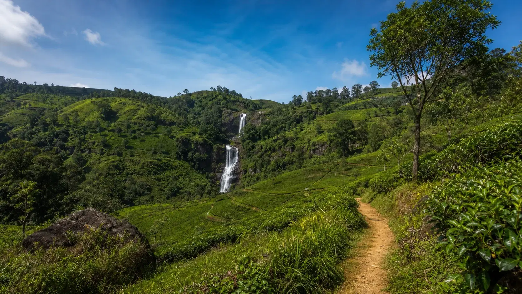
From the factory a village track leads to views of St Clair's Falls. This is one of Sri Lanka's widest and most striking waterfalls, commonly known as the Little Niagara of Sri Lanka, and it is one of the two headline sights of the stage.

Shortly after, the trail zigzags upward through manicured tea hills with views over the Kotmale Valley below and the contours of the Nanu Oya River visible in the distance. If you walked Stage 4, you looked at the Kotmale Reservoir from the other side of the same valley system.

At around 12 km the trail reaches a small village within the Derryclaire Estate. Beyond it lies a final hill and a stretch of shaded forest, which is welcome after the open tea sections.

The trail then briefly joins the Talawakele to Hatton road at Kotagala, marked by a vividly painted Hindu kovil that serves as the landmark for the end of the stage and the start of Stage 7.

Kotagala is a convenient endpoint. It has a train station, tuk-tuks and shops for restocking, which makes it one of the easier stage finishes on the trail even with the railway out of service.

Valley and hamlet walking after TalawakeleSt Clair Tea Factory at around 9 km, with its own stationSt Clair's Falls, the Little Niagara of Sri LankaViews over the Kotmale Valley and the Nanu Oya RiverDerryclaire Estate village at around 12 kmFinishes at a painted kovil in Kotagala

St Clair's Falls and Devon Falls

Two of Sri Lanka's best-known waterfalls sit within a few kilometres of this stage, and they are the reason a lot of people will choose Stage 6 over its neighbours.

St Clair's Falls is the one the trail actually delivers you to, via a village track from the St Clair Tea Factory. It is among the widest waterfalls in the country and its nickname, the Little Niagara of Sri Lanka, is about breadth rather than height.

Devon Falls is listed among the stage's points of interest and sits in the same area, most commonly viewed from the Talawakele side. It is taller and narrower than St Clair's and is usually seen from a distance across the valley rather than approached closely.

Both are dramatically weather-dependent, and this is the one place where our usual advice about seasons inverts. Dry-season walking gives clearer views of everything else on this stage, but the falls are considerably more impressive after rain.

In a dry spell, particularly late in the dry season, both can reduce to a fraction of their potential volume. If waterfalls are your main motivation, walking in a wetter month or shortly after a rainy period will serve you better, with the trade-off of mist, slippery ground and reduced long-range views.

There is a second factor worth knowing. These falls sit in a catchment that feeds hydroelectric infrastructure, and flow can be affected by water management as well as rainfall. A visitor arriving on a dry day may find less water than the photographs suggested for reasons that have nothing to do with the weather that week.

We are flagging that rather than making a specific claim about diversion schedules, because operational details vary and are not reliably published. Ask locally on the day if it matters to you.

Safety, as at every Sri Lankan waterfall: view from safe and publicly accessible ground, do not climb wet rocks, and do not approach fast-flowing water after heavy rain. Waterfall accidents are among the more common serious incidents involving visitors in this country and almost all of them are avoidable.

St Clair's Falls is reached by a village track from the tea factoryDevon Falls is usually viewed from a distance near TalawakeleBoth are far more impressive after rain than in a dry spellFlow can be affected by water management, not just rainfallView from safe ground; do not climb wet rocks

Transport at Both Ends

Both ends of Stage 6 are functioning towns on roads, which makes this one of the easier stages in the cluster for logistics despite the rail closure.

Watagoda is where Stage 5 finishes, so if you are walking sequentially you are already there. Coming fresh, it is reached by road from the Hatton or Talawakele direction.

Kotagala at the far end sits on the Talawakele to Hatton road and has tuk-tuks and shops. Getting a vehicle to collect you there is straightforward, and buses run this road.

The obvious base for this stage is Hatton, which is the largest town in the area and has the widest range of accommodation, though Stage 6 does not actually pass through it. Talawakele and Kotagala both have more limited options.

As with the rest of the trail, arrange your driver in advance, agree the pickup point precisely, and give a realistic time window. Signal along the route is poor and renegotiating mid-hike is not a plan.

There is one logistical advantage unique to this stage: it passes through Talawakele at roughly the halfway point, on a main road. That means a genuine bail-out option exists in the middle of the day if weather turns or someone in your group is struggling. Very few stages on this trail offer that.

For the wider 2026 picture, the hill country is currently reached by road for the Kandy to Nanu Oya stretch because of the Main Line closure. Build longer transfer times into your planning than guidebooks assume, and read our dedicated guide on what is and is not running before locking in dates.

Both trailheads are functioning towns on roadsKotagala has tuk-tuks, shops and bus connectionsHatton is the practical accommodation base for the areaTalawakele at halfway is a genuine mid-stage bail-out pointConfirm pickup arrangements before you start; signal is poor

When to Walk Stage 6

This is the stage where our standard January to April recommendation needs qualifying, because the two headline sights want opposite conditions from the rest of the route.

For clear views over the Kotmale Valley, comfortable walking and firm ground, January to April is the better window, as across the whole trail.

For St Clair's Falls and Devon Falls at anything like full volume, you want water in the system, which means walking during or shortly after a wetter period.

Dimbula sits on the western slopes and catches the southwest monsoon directly, roughly May to September. That is the district's defining weather pattern and it is when the falls run strongest.

Our practical suggestion: if the waterfalls are a major reason you are walking this stage, aim for the shoulder weeks either side of the wet season, or simply walk within a few days of significant rain. If the tea landscape and the valley views matter more, stick with the dry months and treat the falls as a bonus.

Time of day follows the usual highland pattern. Mist builds through the afternoon, so an early start gives better odds on the Kotmale Valley views in the later part of the stage.

Given our 5 to 7 hour estimate, a 7:00 am start is comfortable. This is not a stage that demands a pre-dawn effort, unlike Stage 10 with its park entry cutoff.

One scheduling note: Talawakele is a working town and is busiest during commuting and market hours. Passing through mid-morning is more pleasant than at either end of the day, which happens naturally on a normal 7:00 am start.

January to April for views and firm groundWetter periods for the waterfalls at full volumeDimbula catches the southwest monsoon directlyWalk within a few days of rain if the falls matter mostA 7:00 am start is comfortable for this stage

Preparation and What to Carry

Stage 6 is one of the friendlier stages for resupply. It passes through Talawakele at roughly halfway, plus villages, a tea factory with refreshment options, and finishes in Kotagala where you can restock.

That said, do not build your plan on it. Carry at least two and a half litres of water per person and enough food for the day. Shops keep their own hours and a factory visit may not be possible on the day you arrive.

Footwear should be trail shoes with grip. The mix of estate track, tarmac, railway crossings and one shaded forest section does not demand boots, but smooth soles on wet tarmac are the most common footwear complaint on this stage.

Sun protection matters on the open tea sections between Talawakele and St Clair, which have limited shade.

A packable rain layer is essential in this district regardless of month, because the western slopes get weather when the eastern side does not.

Cash in small denominations for Talawakele, the tea factory, village shops and Kotagala. Nothing along the route takes cards.

Leech socks if there has been rain, particularly for the shaded forest stretch after Derryclaire.

Then the standard set: offline maps and the stage route downloaded, power bank, first aid kit, emergency numbers saved offline, and your trail pass loaded in the app before you leave signal.

Walking poles are optional here. With only around 100 m of net descent and no sustained downhill, this is one of the few stages in the cluster where most people will not miss them.

Better resupply than most stages, but do not rely on itAt least two and a half litres of water per personTrail shoes with grip for wet tarmac and estate trackRain layer regardless of month on the western slopesPoles optional; there is no sustained descent

The Trail Pass

The Pekoe Trail pass applies here as everywhere. Foreign visitors pay USD 10 per stage, Sri Lankan residents pay LKR 600 per stage, and children under 12 are free. Members of the trail organisation receive unlimited passes.

Buy it through the official Pekoe Trail app or web portal, using the same email for both, and do it the night before rather than at the trailhead where signal is poor.

The reasoning across the trail is consistent. The route crosses public land, private tea estates and village land, access exists because landowners agreed to it, the original donor funding has ended, and the organisation states that landowners may restrict access to hikers without a valid pass. Revenue funds maintenance, signage, the app, safety updates and community programmes.

On this stage that arrangement is particularly visible. You walk through the Holyrood Estate, its factory grounds, the Talawakele Estate, the St Clair Estate and the Derryclaire Estate. That is five separate commercial operations whose permission you are relying on in a single day.

Passing through a working tea factory's grounds, as this stage does at Holyrood, is not a right. It is an arrangement, and it is the kind of access most likely to be withdrawn if hikers behave badly.

There is no checkpoint on Stage 6. Buy the pass anyway.

Note that some stages elsewhere require additional tickets on top of the pass. Stage 6 does not, but Stage 10 in this same cluster requires a Horton Plains National Park ticket that costs several times the trail pass, so do not assume the pattern holds as you move along.

Group size is capped at 20 people under trail policy.

USD 10 per stage for foreign visitors, LKR 600 for residentsBuy the night before; trailhead signal is poorThis stage crosses five separate estates in one dayPassing through factory grounds is an arrangement, not a rightStage 10 in this cluster needs a separate park ticket

Walking Stage 6 Responsibly

This stage has a High people-interaction rating and passes through a working town, several estates, a factory and multiple villages. Ordinary courtesy is the operating standard for most of it.

The factory grounds at Holyrood deserve specific care. This is an industrial workplace with machinery, vehicles and people doing jobs. Walk through it, do not wander, do not photograph inside without permission, and follow any instruction from staff.

Railway discipline is a responsibility as much as a safety matter. Do not linger on the tracks for photographs, do not walk on the rails beyond the marked route, and do not obstruct works crews. The line is under repair and the people working on it have a difficult job.

At the kovils at the start and the end of the stage, and any temple along the way: cover shoulders and knees, remove shoes where indicated, and do not photograph during observances.

Stay on marked paths through the tea estates and do not cut between rows. Do not pick tea leaves.

At St Clair's Falls, do not leave anything behind, do not climb on wet rock for photographs, and do not enter restricted areas. The falls sit in a managed catchment.

Ask before photographing people. This applies especially in Talawakele, where you are walking through a town of people going about their working day, and around the line rooms and estate housing you will pass.

Buy locally. Talawakele for lunch, a village shop, tea at the St Clair factory, a meal in Kotagala at the finish. This stage makes spending money along the route unusually easy, which is exactly what the trail was set up to encourage.

Carry out everything you carry in, and pick up litter where you can.

The Holyrood factory is a workplace, not an attractionDo not linger on the railway or obstruct works crewsCover up at the kovils at both ends of the stageAsk before photographing people in TalawakeleSpending locally is unusually easy on this stage

Should You Walk Stage 6? An Honest Verdict

Stage 6 is the most consistently interesting stage of the first six, and it is also the least dramatic. Both of those things are true and which matters more depends on what you want from a day.

Walk Stage 6 if you like variety. Almost nothing on this stage lasts more than a couple of kilometres before something else appears: lakes, a kovil, a banyan tree, estate trails, a factory, street art, a railway town, valley hamlets, a waterfall. There is no dead ground on it.

Walk it if you want to understand the tea industry rather than just photograph it. Talawakele and the Dimbula district are where the volume is, and walking through the working centre of the country's largest growing area teaches you something a heritage estate visit does not.

Walk it if you are a confident solo hiker. Like Stage 5, this stage currently carries no advice against walking alone, and its High people-interaction rating means help is rarely far away.

Walk it if the waterfalls appeal, but time it for water rather than for sunshine.

Do not walk it expecting a mountain day. There is no summit, no pass, no single big view. If you have three days in this region and want the drama, Stage 8's Adam's Peak saddle and Stage 9's Jacob's Ladder deliver more spectacle.

Do not walk it expecting solitude. This is a populated stage through a working district and it is not where you go to be alone.

Do not plan to arrive or leave by train without confirming the current rail position, and do not treat a closed line as a safe place to walk.

For most visitors to this part of the hill country, Stage 6 is a genuinely good day out and one of the easier stages to fit into a normal itinerary. Paired with Stage 5 the day before, it makes a two-day sequence with no landslide flag on either day, which right now is worth something.

The most varied stage of the first sixThe best stage for understanding the working tea industrySuitable for confident solo hikersNot a mountain day; no summit or passPairs with Stage 5 for two unflagged consecutive days

Travel Tips

  • Plan for the Moderate grading on the stage page rather than the Easy grading on the index
  • Allow 5 to 7 hours elapsed; this stage has an unusual number of legitimate stops
  • Do not plan rail transport at either end without confirming the Main Line position first
  • Treat the closed railway as live infrastructure; engineering traffic still uses it
  • Cross the tracks briskly at the designated points and never stop on the line to photograph
  • Time your walk for wetter conditions if the waterfalls are your main reason for coming
  • Use Talawakele as your mid-stage bail-out point if weather turns
  • Carry at least two and a half litres of water despite the good resupply options
  • Eat lunch in Talawakele rather than carrying it from a hotel
  • Wear shoes with grip; wet tarmac is the most common complaint on this stage
  • Do not photograph inside the Holyrood factory without permission
  • Carry small denomination cash for the town, factory and village shops
  • Save the Thalawakele, Dimbula Pathana and Kotagala emergency numbers offline
  • Buy your trail pass the night before; trailhead signal is poor
  • View the waterfalls from safe ground and never climb wet rock

Frequently Asked Questions

How long is Pekoe Trail Stage 6?

The stage page gives 14.9 km and the stage index gives 14.97 km, with 523 m of elevation gain and 627 m of loss to a maximum of around 1,364 m. The route description separately refers to a landmark at the 15.3 km point, so treat the length as approximately 15 km.

Is Stage 6 Easy or Moderate?

The official pages disagree. The stage index grades it Easy; the stage page grades it Moderate in both directions. We suggest planning for Moderate, since 523 m of gain and 627 m of loss across 15 km is a real day's walk.

How long does Stage 6 take?

The official average duration is 4 hours 30 minutes, which is credible as moving time. We suggest 5 to 7 hours elapsed, because this stage has more worthwhile stops than most: a kovil, a banyan tree, two tea factories, a town, and a waterfall.

Can I take the train to or from Stage 6?

Not at present. Watagoda, Talawakele, St Clair and Kotagala all sit on the Rambukkana to Nanu Oya section of the Main Line, closed for repairs since Cyclone Ditwah damaged the line in late 2025, with reopening expected around January 2027. Arrange road transport and confirm the current position before travelling.

Is it safe to walk along the railway on this stage?

The official route crosses the line three times and follows it for about 75 metres at designated points. Do that briskly and carefully. A closed line still carries engineering trains, works vehicles and track crews, so do not treat the lack of passenger service as permission to walk on the rails or stop on the line for photographs.

Does Stage 6 pass St Clair's Falls?

Yes. A village track from the St Clair Tea Factory at around the 9 km mark leads to views of St Clair's Falls, one of Sri Lanka's widest waterfalls and commonly called the Little Niagara of Sri Lanka. Devon Falls is also listed among the stage's points of interest and is usually viewed from the Talawakele area.

When are the waterfalls at their best?

After rain. Both falls are dramatically weather-dependent and can reduce substantially in a dry spell. This is the one aspect of Stage 6 where dry-season walking is a disadvantage. Flow can also be affected by water management in the catchment, not only rainfall, so ask locally on the day.

Is Stage 6 safe to hike right now?

At the time of writing it shows as open with only a standard advisory about wet and slippery sections after rainfall, and no landslide precaution. That makes it one of the few unflagged stages in this part of the trail. Statuses change, so check the stage page and TrailWatch before you go.

Can I hike Stage 6 alone?

There is currently no advice against solo hiking on this stage, unlike stages 2, 3, 4, 7 and 8. Combined with the High people-interaction rating and the mid-stage town, it is one of the more realistic solo options in this part of the trail.

Where is the halfway point and can I stop there?

Talawakele, at roughly the midpoint, sits on the Hatton to Nuwara Eliya road with shops, eateries and transport. It is a genuine mid-stage bail-out option, which very few Pekoe Trail stages offer.

What is Dimbula and why does it matter?

Dimbula is a high-grown tea district on the western slopes of the Central Highlands, described by the trail organisation as de facto the largest tea-growing area in Sri Lanka. Talawakele is its centre. The district catches the southwest monsoon directly, and the cold dry period afterwards produces the character it is known for.

Do I need a trail pass for Stage 6?

Yes. Foreign visitors pay USD 10 per stage, Sri Lankan residents pay LKR 600, and children under 12 are free. Buy it through the official app or web portal the night before, since signal at the trailhead is poor.

Where should I stay for this stage?

Hatton is the largest town in the area and has the widest range of accommodation, though the stage does not pass through it. Talawakele and Kotagala both have more limited options. The trail organisation also maintains an accommodation directory of partner properties along the route.

Is Stage 6 suitable for families?

The full 15 km stage is long for children, and it involves three railway crossings, which requires supervision. A better family option is the shorter Talawakele to Kotagala half, or viewing St Clair's and Devon Falls by road. Stage 1 remains the strongest family stage on the trail.

What is the sign about hugging a tree?

A sign on a warehouse facade near the Holyrood Estate main bungalow, at around the 3.7 km mark, reads did you hug a tree today. It has become a minor landmark among hikers on this stage and appears in the trail organisation's own stage description.

Reader notes

Join the conversation

Share your question, tip, or travel experience for this guide.

Comments

0 comments

Loading...

Ready to turn inspiration into a Sri Lanka trip?

Use LankaTrip to plan your journey, connect with local guides, and make this itinerary a reality.

Need help planning?

Plan your Sri Lanka adventure

Plan my trip