
LankaTrip Insights

27 min read

Pekoe Trail Stage 8 in 2026: Norwood to Bogawantalawa, Adam's Peak Without the Climb and a Victorian Photographer's Grave

Stage 8 climbs a ridge separating the Bogawantalawa and Maskeliya valleys, delivering a view of Adam's Peak across Castlereagh Lake from a saddle at the 3.8 km mark. It crosses a designated conservation corridor, it has a Low people-interaction rating, and it finishes in the Golden Valley of Tea.

Back to blog
Pekoe Trail Stage 8 in 2026: Norwood to Bogawantalawa, Adam's Peak Without the Climb and a Victorian Photographer's Grave

Tens of thousands of people climb Adam's Peak every season. They start in the dark from Dalhousie, walk several thousand steps through the night, and arrive at the summit cold and exhausted for sunrise.

Stage 8 of the Pekoe Trail gives you the mountain from a saddle at the 3.8 km mark, in daylight, across a lake, after about ninety minutes of walking.

That is not a substitute for the pilgrimage, which is a religious act rather than a viewpoint, and we would not pretend otherwise. But as a way of seeing the most sacred mountain in Sri Lanka properly, framed by the Maskeliya Valley and reflected in Castlereagh Lake, it is remarkably efficient.

The rest of the stage earns its place too. This is the first stage in the Hatton cluster where the people-interaction rating drops to Low, meaning the estate villages of Stage 7 give way to something quieter. The trail crosses a designated conservation corridor. And it finishes in the Bogawantalawa Valley, which the trail organisation calls the Golden Valley of Tea, a name it fully earns.

There is also one of the more unexpected pieces of history on the entire route. Julia Margaret Cameron, one of the most significant portrait photographers of the nineteenth century, spent her final years in Ceylon and is buried at a church the trail passes at around the 14 km mark. Almost nobody who walks past knows.

Two practical notes before you plan. Stage 8 currently carries a precaution about increased landslide risk following persistent rainfall. And the stage index flags special trail hours that the stage page does not specify, which given the conservation corridor is worth confirming before you commit to a start time.

This guide covers the route, the Adam's Peak view and when to catch it, the corridor, the Cameron connection, and honest advice on the day.

Quick Summary

  • Stage 8 runs 15.93 km from Norwood to Bogawantalawa, gaining 562 m and losing 377 m, to a maximum of around 1,543 m
  • It is graded Moderate in both directions with an official average duration of 4 hours 30 minutes; plan 6 to 8 hours elapsed
  • People interaction drops to Low, the first time in this cluster
  • The saddle at around 3.8 km delivers the stage's signature view: Adam's Peak across the Maskeliya Valley
  • The trail crosses a designated conservation corridor with marked start and end points
  • The stage index flags special trail hours that are not specified on the stage page
  • Between roughly 11 km and 14 km the trail is largely unshaded, making a hat essential
  • The stage ends near the church where the Victorian photographer Julia Margaret Cameron is buried

The Numbers and the Shape of the Day

Stage 8 is 15.93 km with 562 m of elevation gain, 377 m of loss, a maximum elevation of around 1,543 m, an average duration of 4 hours 30 minutes, people interactions rated Low, region Hatton, and a grading of Moderate in both directions.

The index and stage page agree on length and grading here, which after Stage 6 is worth noting.

The shape of the day is unusually clean and the trail organisation describes it plainly: an initial steady and sometimes demanding ascent, followed by a gentle continuous descent into the valley.

In practice that means the hard work is front-loaded. From Norwood the trail climbs south toward the ridge for roughly the first 4 km, with a sharp dogleg upward at 0.4 km and a zigzag through the Norwood Estate for about 3 km after crossing the Norwood to Upcot road at 1.1 km.

The official description makes a point that is worth internalising before you set out: it may feel counter-intuitive to climb away from the valley, but trust the GPS. The ascent exists to deliver the view.

After the saddle at around 3.8 km the day becomes considerably easier. The descent into the Bogawantalawa Valley begins after around 7.3 km and is gradual.

The 562 m of gain is modest by the standards of this trail. Stage 4 climbs 1,195 m and Stage 10 climbs 983 m. What makes Stage 8 feel like work is that most of its gain happens in the first quarter of the distance.

The official 4 hours 30 minutes is a fit hiker's moving time. Given the front-loaded climb, the saddle you will not want to rush, the unshaded middle section and the church at the end, we suggest planning 6 to 8 hours elapsed.

15.93 km, 562 m gain, 377 m lossMaximum elevation around 1,543 mClimbing is front-loaded into the first 4 kmGentle continuous descent after around 7.3 kmOfficial 4h30; plan 6 to 8 hours elapsed

The Adam's Peak View, and How to Actually Get It

At around 3.8 km the trail crosses the Norwood to Upcot road for the second time, this time at a saddle point. This is the moment the stage exists for.

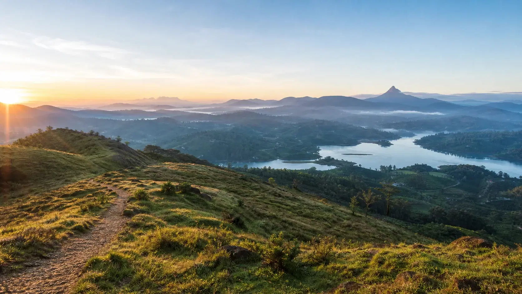
From here the Maskeliya Valley opens out, with Adam's Peak rising prominently on the far side of the lake. The trail organisation calls this vantage point one of the highlights of the stage and it is not overselling.

Adam's Peak, or Sri Pada, is one of the most significant sacred sites in South Asia. The footprint enshrined at its summit is revered across religions, associated with the Buddha in Buddhist tradition, with Adam in Islamic and some Christian traditions, and with Shiva in Hindu tradition. It is one of the few places on earth held sacred by four faiths simultaneously.

Seeing it from here rather than standing on it is a genuinely different experience, and arguably a better one for understanding the mountain's place in the landscape. From the summit you cannot see the peak. From this saddle you can see exactly why it commands the region.

Now the practical part, because this view is entirely conditional on weather.

Morning is essential. Highland cloud builds through the day and by early afternoon the peak is frequently hidden. Reaching the saddle by mid-morning at the latest gives you the best odds, which on a 7:00 am start from Norwood happens naturally.

Season matters enormously. The Adam's Peak pilgrimage season runs roughly from the December Unduwap Poya to the Vesak Poya in May, and that period broadly aligns with the drier, clearer months on this side of the highlands. Outside the season the mountain is more often in cloud.

There is a bonus during pilgrimage season that almost no guide mentions. The path up Adam's Peak is illuminated at night during the season, so a hiker staying near Bogawantalawa or Norwood can sometimes see the lit route threading up the mountain after dark. It is a striking sight and it costs nothing.

If you reach the saddle and the peak is in cloud, wait twenty minutes if you have the time. Highland cloud moves, and a summit that is invisible on arrival is often clear enough for a photograph by the time you have finished a snack.

The saddle at around 3.8 km is the stage's signature viewpointAdam's Peak is sacred across four faithsMorning is essential; cloud builds through the dayPilgrimage season runs roughly December to MayThe pilgrimage path is illuminated at night during the season

The Conservation Corridor and the Special Trail Hours

Among the points of interest listed for Stage 8 are two entries that appear on no other stage in this cluster: a conservation corridor start point and a conservation corridor end point, attributed to the Wilderness and Wildlife Conservation Trust.

A conservation corridor is a protected strip of habitat that allows wildlife to move between larger areas of forest. In the Central Highlands, fragmented by more than a century of tea planting, these corridors matter enormously. Animals that cannot move between forest patches cannot maintain viable populations.

The Sri Lankan leopard is the species most associated with highland corridor work. Leopards in the hill country range across large territories and are heavily affected by habitat fragmentation. Other species using such corridors include sambar, various endemic birds, and smaller mammals.

This connects directly to something otherwise unexplained. The stage index flags Stage 8 with a special trail hours note, and the trail organisation's general guidance states that most stages are open from 6 am to 6 pm, with some open for shorter periods, particularly in wildlife corridors and protected areas.

Putting those together, it is reasonable to infer that Stage 8's restricted hours relate to the conservation corridor. We are presenting that as an inference rather than a stated fact, because the stage page does not say so explicitly and we would rather flag our reasoning than assert something we cannot source.

What we can say confidently is that you should confirm the actual hours in the official Pekoe Trail app before planning an unusually early or late start on this stage. Do not assume 6 am to 6 pm applies.

Behaviour within the corridor matters more than on ordinary estate land. Stay strictly on the trail. Do not enter the forest on either side. Do not leave food or waste of any kind. Keep noise moderate rather than either silent or loud: you want animals aware of you and moving away, not surprised.

Do not attempt to seek out or track wildlife, and do not use playback calls or bait for photography. A corridor works because animals feel safe crossing it, and that safety is the entire conservation value.

Encounters are unlikely on a busy walking day. If you do see something, watch from where you are, do not approach, and do not block the direction it is travelling.

The trail crosses a designated conservation corridor with marked endpointsCorridors let wildlife move between fragmented forest patchesSpecial trail hours are flagged on the index but not specifiedRestricted hours in wildlife corridors are consistent with trail policyStay on the trail, leave no waste, do not seek out wildlife

The Route in Detail

Norwood is the gateway to the Bogawantalawa Valley and a genuine crossroads, connecting Hatton to Maskeliya and Adam's Peak, with a scenic backroad running south to Balangoda.

The trail leaves Norwood heading directly south, climbing toward the ridge that separates the Bogawantalawa and Maskeliya valleys. At around 0.4 km it doglegs sharply upward, twisting and turning until it crosses the Norwood to Upcot road at around 1.1 km.

Beyond the road the path zigzags upward through the Norwood Estate for roughly 3 km. As you gain elevation the Norwood Tea Factory becomes visible to the right, and the views back over the valley improve steadily.

At around 3.8 km comes the saddle, the second crossing of the Norwood to Upcot road, and the Adam's Peak view described above.

After the saddle the trail continues along the high ground before beginning its descent into the Bogawantalawa Valley after around 7.3 km, entering the Kew Estate.

At around 8.0 km the path narrows into a less-travelled trail marked by a small Hindu shrine. Steps near the shrine lead further into the estate, and the trail organisation describes this as a unique and remote section of the journey. This is the quietest walking on the stage.

By around 9.7 km you pass the Kew Estate Tea Factory and the path becomes gentler through the valley countryside.

Between roughly 11 km and 14 km the trail zigzags through sprawling tea fields. This section is largely unshaded and the official guidance is explicit that a hat is essential on sunny days. Given that you will typically be walking it in the middle of the day, take that seriously.

At around 14 km the trail joins the main Norwood to Bogawantalawa road, with a historic church standing to the left. This is the Cameron connection, covered below.

The trail then passes the Bogawantalawa Planters' Club on the right and descends into the heart of Bogawantalawa town, where the stage concludes.

Sharp dogleg climb from 0.4 kmZigzag through Norwood Estate for around 3 kmSaddle and Adam's Peak view at around 3.8 kmHindu shrine and narrow remote section at around 8.0 kmKew Estate Tea Factory at around 9.7 kmUnshaded tea fields from roughly 11 km to 14 km

Julia Margaret Cameron: A Victorian Photographer in the Tea Country

At around the 14 km mark the trail joins the main road beside a historic church. The trail organisation notes that the church is closely tied to Julia Margaret Cameron, who is buried there.

For anyone who has not encountered the name, this is a considerably bigger deal than a roadside church in a tea valley suggests.

Julia Margaret Cameron was one of the most important portrait photographers of the nineteenth century. Working in Britain from the 1860s, she produced a body of portrait work that broke sharply with the conventions of her era: deliberately soft focus, dramatic lighting, close and psychologically intense framing. Her subjects included many of the leading intellectual figures of Victorian Britain.

Her work was controversial in her lifetime, criticised for technical imperfection by photographers who valued sharpness. It is now regarded as foundational to photography as an art form rather than a documentary process, and her portraits hang in major collections worldwide.

She moved to Ceylon in the later part of her life, where her family had coffee and later tea interests, and she died there in 1879. She is buried in the Bogawantalawa area.

There is something quietly remarkable about that. One of the founding figures of artistic photography spent her final years in this valley, and the overwhelming majority of people who walk or drive past her grave have no idea.

The trail organisation describes the church as a worthwhile stop to honour her contributions to photography and her connection to the region, and we would agree. It takes ten minutes at the end of a long day.

If you are a photographer walking this trail, and a great many people who walk the Pekoe Trail are, there is a certain symmetry in ending a day of landscape photography at the grave of the woman who argued that photographs could be art rather than records.

Treat the church as an active place of worship rather than a monument. Cover shoulders and knees, do not photograph during services, and be quiet.

A major Victorian portrait photographer is buried near the trailHer soft-focus, psychologically intense work was foundational to art photographyShe moved to Ceylon in later life and died there in 1879The church sits beside the main road at around 14 kmIt is an active place of worship, not a monument

Bogawantalawa: The Golden Valley of Tea

The Bogawantalawa Valley is where this stage finishes and where Stage 9 begins, and it has one of the better reputations in Sri Lankan tea.

It is known as the Golden Valley of Tea, celebrated for mist-shrouded rolling hills, the mirror-like Castlereagh Lake, and its status as one of the most picturesque tea-growing regions in the country. Stage 7 gave you the reservoir from above; Stage 8 brings you down into the valley itself.

The valley is home to a set of estates that carry real weight in the industry, including Norwood, Kotiyagala, Tientsin, Kew and Loinorn, the last of which sits between the Peak Wilderness and Horton Plains National Park.

The trail organisation describes the valley as the golden bowl of Sri Lanka's finest tea. Tea from this valley is high-grown and the region's reputation rests on quality rather than volume, which distinguishes it from Dimbula around Talawakele where the emphasis is on scale.

Bogawantalawa town sits at an elevation of 1,279 m and is a working tea town rather than a tourist destination. It has shops, eateries and basic services, and it is the natural place to eat and rest at the end of the stage.

It is also a crossroads of sorts. From here the road continues toward Dayagama and the Agarapatana Valley, which is where Stage 9 heads.

Accommodation in the valley is more varied than in most places on this trail, ranging from basic guesthouses to a handful of restored planters' bungalows. The trail organisation maintains a directory of partner properties, and as elsewhere on this site we do not name individual businesses.

If you are walking stages 7, 8 and 9 in sequence, the Norwood and Bogawantalawa area is where you will spend two nights, and it is a pleasant place to do it.

Known as the Golden Valley of TeaCastlereagh Lake and mist-shrouded rolling hillsHome to Norwood, Kotiyagala, Tientsin, Kew and Loinorn estatesBogawantalawa town sits at 1,279 mA quality-focused district rather than a volume one

Current Safety Position

Stage 8 currently carries a precaution stating that persistent rainfall has increased landslide risk, advising hikers to proceed only if conditions are suitable and to monitor local weather. This is the same wording as Stage 7.

It differs from the precaution on stages 2, 3 and 4, which explicitly advise avoiding solo hiking. The Stage 8 wording does not include that clause and instead places the judgement on the hiker: proceed only if conditions are suitable.

We would still not walk this stage alone in current conditions. The people-interaction rating drops to Low here, which means long stretches with nobody around, and mobile signal is rated poor. Combined with a landslide flag, that is not a good combination for a solo walker.

The single listed emergency point is Bogawantalawa Police Station. That is fewer than Stage 7's four, which reflects how much less populated this stage is.

Save that number offline before you start, along with your accommodation and driver contacts.

The practical rules: do not walk during or immediately after persistent rainfall, check the forecast for the Bogawantalawa and Maskeliya area specifically, and check the official stage page and TrailWatch the night before and the morning of your walk.

There is a second, separate constraint on this stage: the unspecified special trail hours flagged on the index. Confirm those in the official app rather than assuming the standard 6 am to 6 pm window applies.

And a third consideration that is not a safety warning but affects planning: the unshaded section between roughly 11 km and 14 km is a genuine heat risk on a clear day at 1,400 m. Sun protection here is not optional and neither is water.

Current precaution: persistent rainfall has increased landslide riskSame wording as Stage 7; no explicit solo hiking clauseLow people interaction plus poor signal makes solo walking unwiseOnly one listed emergency point: Bogawantalawa Police StationConfirm the unspecified special trail hours in the app

Transport at Both Ends

Norwood, the start, is a crossroads town connecting Hatton, Maskeliya and the road south to Balangoda. That makes it one of the better-connected trailheads on this part of the route, and getting a vehicle there is straightforward.

Bogawantalawa, the finish, is a working tea town with shops and basic services, on the road that continues toward Dayagama. It is a comfortable place to wait for a pickup.

Because both ends are on roads and both are towns, Stage 8 has considerably simpler logistics than stages 3, 4 or 10, none of which have that.

Arrange a driver in advance, agree the pickup point precisely, and give a realistic window. Our 6 to 8 hour estimate should be the basis, not the official 4 hours 30 minutes.

Signal along the route is poor, so confirm arrangements before you start.

If you are walking stages 7 and 8 consecutively, staying in the Norwood or Dickoya area between them removes a transfer entirely, since Stage 7 finishes and Stage 8 begins in the same town.

If you are continuing to Stage 9, staying in Bogawantalawa does the same thing, since Stage 9 starts there.

That makes stages 7, 8 and 9 unusually easy to chain: three consecutive stages where each finish point is the next start point and all three are towns with accommodation. Very little of the Pekoe Trail works that neatly.

For the wider 2026 picture, the hill country is reached by road for the Kandy to Nanu Oya stretch while the Main Line remains closed for repairs after Cyclone Ditwah. Hatton station sits within the closed section, so build longer transfers into your planning.

Both trailheads are towns on roads with simple logisticsNorwood connects Hatton, Maskeliya and the Balangoda roadStage 7 finishes and Stage 8 starts in the same townStages 7, 8 and 9 chain unusually neatlyPlan transfers around 6 to 8 hours, not the official 4h30

When to Walk Stage 8

This stage has a clearer optimal window than most on the trail, because its signature view depends on a specific mountain being visible.

January to April is the strongest general window, as across the highlands. But for Adam's Peak specifically, the wider pilgrimage season, running roughly from the December Unduwap Poya to the Vesak Poya in May, is when the mountain is most reliably clear.

Outside that period, particularly during the southwest monsoon from roughly May to September, the Maskeliya Valley is frequently under cloud and the view from the saddle may not materialise at all.

That matters more here than on most stages because the view is the reason for the climb. A cloudy Stage 8 is a pleasant walk. A clear Stage 8 is one of the better days on the entire trail.

Time of day is equally decisive. Highland cloud builds through the day, so reaching the saddle in the morning is essential. On a 7:00 am start from Norwood you will arrive at around 9:00 am, which is close to ideal.

There is a competing consideration. The unshaded section between roughly 11 km and 14 km is most comfortable earlier in the day, and a 7:00 am start puts you there around midday, which is the hottest part. There is no way to optimise both; the saddle view is worth more, so start early and manage the heat with a hat, sunscreen and water.

The current landslide precaution adds a further filter. Recent rainfall matters more than the calendar month, so check conditions in the days before rather than relying on the season.

Build flexibility into your plan. If the morning looks cloudy and you have another day available, moving this stage is worth doing. Very few stages on this trail reward patience with the weather as directly as this one.

The Adam's Peak pilgrimage season roughly December to May is bestCloud frequently hides the peak during the southwest monsoonReach the saddle in the morning; cloud builds through the dayA 7:00 am start puts you at the saddle around 9:00 amWorth moving by a day if the morning looks cloudy

Preparation and What to Carry

The two defining factors for packing on this stage are the Low people-interaction rating and the unshaded middle section.

Low people interaction means resupply is not reliable. Unlike Stage 6 with its mid-stage town, or Stage 7 with its villages, Stage 8 has long stretches with nothing. Carry at least three litres of water per person and all your food for the day.

Sun protection is the item the official description singles out. Between roughly 11 km and 14 km the trail is largely unshaded and you will typically be walking it around midday at 1,400 m. A hat is described as essential and we would add sunscreen, sunglasses and ideally a light long-sleeved layer.

Footwear should be trail shoes or light boots with grip. The front-loaded climb and the current wet-ground precaution both make grip matter.

Walking poles are useful for the sustained climb in the first 4 km more than for the gentle descent afterwards. If you carry them habitually, bring them.

A packable rain layer regardless of month. This is the western side of the highlands.

Leech socks if there has been rain, particularly for the narrow section around the Hindu shrine at 8 km and the forested corridor stretch.

Binoculars are genuinely worth carrying on this stage, which is unusual advice from us. The Adam's Peak view is at distance, and the conservation corridor makes bird sightings more likely than elsewhere in the cluster.

Then the standard set: offline maps and the stage route downloaded, power bank, first aid kit, the Bogawantalawa Police Station number saved offline, headtorch, cash in small denominations for Bogawantalawa, and your trail pass loaded in the app before you leave signal.

At least three litres of water; resupply is unreliableA hat is described as essential for the unshaded 11 to 14 km sectionGrip matters given the climb and the wet-ground precautionPoles help on the front-loaded ascentBinoculars are worth carrying for the peak view and the birds

Walking Stage 8 Responsibly

The conservation corridor is the part of this stage that most changes how you should behave, and it is covered in its own section above. The short version: stay strictly on the trail, leave nothing, keep noise moderate, and do not seek out wildlife.

Beyond the corridor, the ordinary trail principles apply with a few stage-specific points.

The Norwood and Kew estates are working commercial operations. Stay on marked paths, do not cut between tea rows, and do not pick leaves. Do not enter the Norwood or Kew tea factories without permission.

The small Hindu shrine at around 8 km is an active religious site in a remote spot. Do not disturb it, do not move anything, and do not use it as a rest stop with food.

At the church at 14 km, remember it is an active place of worship as well as a burial site of historical significance. Cover shoulders and knees, do not photograph during services, and keep your voice down. Visiting a grave is not the same as visiting a monument.

If you visit the Bogawantalawa Planters' Club, treat it as a members' institution extending hospitality rather than an attraction.

With a Low people-interaction rating, your behaviour on much of this stage is unobserved. That makes carrying out all your waste more important rather than less. The trail organisation asks hikers to pick up litter they find as well, and on a quiet stage that is easy to honour.

Drones need landowner permission and should not be flown in the conservation corridor at all. Aerial disturbance is precisely the kind of pressure a wildlife corridor exists to prevent.

Group size is capped at 20 under trail policy, and in a conservation corridor a smaller group is better practice regardless of what the cap permits.

Stay strictly on the trail through the conservation corridorDo not disturb the Hindu shrine at around 8 kmThe church at 14 km is a working place of worshipCarry out all waste; much of this stage is unobservedNo drones in the conservation corridor

Should You Walk Stage 8? An Honest Verdict

If you are walking one stage in the Hatton cluster for the view, this is it.

Walk Stage 8 if you want to see Adam's Peak properly without committing to the night climb. The saddle at 3.8 km delivers the mountain across the Maskeliya Valley in daylight, and ninety minutes of uphill is a very fair price.

Walk it if you found Stage 7 socially interesting but want something quieter. The people-interaction rating drops to Low here and the section around the shrine at 8 km is among the more remote-feeling walking in the cluster.

Walk it if the logistics of the harder stages have put you off. Both trailheads are towns on roads, both are on the same road, and it chains neatly with stages 7 and 9.

Walk it if you are interested in photography, in which case the Cameron grave at the end gives the day a shape that few hiking days have.

Do not walk it in the wrong season if the view is your motivation. Outside the roughly December to May window the Maskeliya Valley is often under cloud, and you will do the climb for grey.

Do not walk it in or immediately after persistent rainfall while the current precaution stands.

Do not walk it alone if you can avoid it. There is no explicit instruction against it on this stage, but Low people interaction, poor signal and a landslide flag together make a poor case for solo walking.

Do not start early or finish late without confirming the special trail hours, which the index flags and the stage page does not specify.

Do not underestimate the unshaded middle section. It is the most common reason people arrive in Bogawantalawa in worse shape than the elevation profile would suggest.

For the traveller it suits, Stage 8 is the best value day in this cluster: the biggest view for the least climbing, in a valley that lives up to its name.

The best view-to-effort ratio in the Hatton clusterAdam's Peak in daylight without the night climbQuieter than Stage 7, easier logistics than stages 9 and 10Season is decisive; December to May for the peakDo not walk it alone or in wet conditions right now

Travel Tips

  • Reach the saddle at 3.8 km in the morning; cloud usually hides Adam's Peak by afternoon
  • Walk this stage roughly between December and May for the best chance of a clear peak
  • Confirm the unspecified special trail hours in the official app before an early or late start
  • Stay strictly on the trail through the conservation corridor and leave no waste
  • A hat is essential for the unshaded section between roughly 11 km and 14 km
  • Carry at least three litres of water; resupply on this stage is unreliable
  • Do not walk during or immediately after persistent rainfall while the precaution stands
  • Do not hike this stage alone given Low people interaction and poor signal
  • Trust the route when it climbs away from the valley at the start; the ascent earns the view
  • Carry binoculars for the distant peak view and for birds near the corridor
  • Save the Bogawantalawa Police Station number offline before you start
  • Stay in Norwood the night before to avoid a pre-dawn transfer
  • Look for the illuminated Adam's Peak path after dark during pilgrimage season
  • Cover shoulders and knees at the church where Cameron is buried
  • Buy your trail pass the night before; signal on the route is poor

Frequently Asked Questions

Can you see Adam's Peak from Pekoe Trail Stage 8?

Yes. At around the 3.8 km mark the trail crosses the Norwood to Upcot road at a saddle point where the Maskeliya Valley opens out and Adam's Peak rises on the far side of the lake. The trail organisation describes it as one of the highlights of the stage.

Do I need to climb Adam's Peak to see it properly?

No, and arguably the view from this saddle shows you more. From the summit you cannot see the peak itself. From the Stage 8 saddle you see the whole mountain in its landscape, across the lake, in daylight. The pilgrimage climb is a religious act rather than a viewpoint, and the two are different experiences.

When is the Adam's Peak view most likely to be clear?

Roughly December to May, which aligns with the pilgrimage season and the drier months on this side of the highlands. Within the day, morning is essential, since highland cloud builds through the afternoon. Reaching the saddle by mid-morning gives the best odds.

How long is Stage 8 and how hard is it?

It is 15.93 km with 562 m of elevation gain and 377 m of loss to a maximum of around 1,543 m, graded Moderate in both directions. The climbing is front-loaded into the first 4 km, after which it becomes a gentle continuous descent. The official duration is 4 hours 30 minutes; we suggest 6 to 8 hours elapsed.

What is the conservation corridor on Stage 8?

The stage's points of interest include a conservation corridor with marked start and end points, attributed to the Wilderness and Wildlife Conservation Trust. Corridors are protected habitat strips that let wildlife move between fragmented forest areas, which matters enormously in highlands broken up by more than a century of tea planting.

What are the special trail hours on Stage 8?

The stage index flags special trail hours but the stage page does not specify them. The trail organisation's general guidance says some stages open for shorter periods, particularly in wildlife corridors and protected areas, which given the conservation corridor is a reasonable explanation. Confirm the actual hours in the official app before planning an early or late start.

Who is buried at the church on this stage?

Julia Margaret Cameron, one of the most significant portrait photographers of the nineteenth century, is buried at the historic church the trail passes at around the 14 km mark. She moved to Ceylon in later life, where her family had planting interests, and died there in 1879.

Is Stage 8 safe to hike right now?

It currently carries a precaution stating that persistent rainfall has increased landslide risk, advising hikers to proceed only if conditions are suitable and to monitor local weather. It is not closed. Check the official stage page and TrailWatch before setting out.

Can I hike Stage 8 alone?

The precaution does not explicitly advise against solo hiking, unlike stages 2 to 4. However, the people-interaction rating drops to Low on this stage, mobile signal is poor, and there is only one listed emergency point. We would not walk it alone in current conditions.

Why does the trail climb away from the valley at the start?

The trail organisation's own description addresses this directly, noting that it may feel counter-intuitive but the ascent is necessary to reach the saddle and the Adam's Peak view. Trust the route rather than looking for a lower alternative.

What is the Golden Valley of Tea?

Bogawantalawa, where the stage finishes. It is celebrated for mist-shrouded rolling hills, Castlereagh Lake, and its reputation as one of the most picturesque tea-growing regions in Sri Lanka. Estates in the valley include Norwood, Kotiyagala, Tientsin, Kew and Loinorn.

Is there shade on Stage 8?

Not between roughly 11 km and 14 km, where the trail zigzags through sprawling open tea fields. The official guidance describes a hat as essential on sunny days, and you will typically be walking this section around midday at around 1,400 m.

Do I need a trail pass for Stage 8?

Yes. Foreign visitors pay USD 10 per stage, Sri Lankan residents pay LKR 600, and children under 12 are free. Buy it through the official app or web portal the night before, since signal on the route is poor.

Can I walk just to the viewpoint and back?

Yes, and for many travellers this is the better plan. An out-and-back from Norwood to the saddle at 3.8 km is roughly 7.6 km, includes the stage's signature view, and removes the need for transport at the far end.

Is Stage 8 suitable for families?

The full stage is long and currently carries a landslide precaution. The out-and-back to the saddle is a more realistic family option for older children, though the climb is sustained. Stage 1 remains the strongest family stage on the trail.

Reader notes

Join the conversation

Share your question, tip, or travel experience for this guide.

Comments

0 comments

Loading...

Ready to turn inspiration into a Sri Lanka trip?

Use LankaTrip to plan your journey, connect with local guides, and make this itinerary a reality.

Need help planning?

Plan your Sri Lanka adventure

Plan my trip