
LankaTrip Insights

28 min read

Pekoe Trail Stage 9 in 2026: Bogawantalawa to Dayagama, Through Jacob's Ladder Into a Hidden Valley of Dairy Farms

Stage 9 climbs through a V-shaped rock pass called Jacob's Ladder and drops into Bopaththalawa, a hidden highland valley of grasslands and dairy farms where thousands of cattle graze at 1,584 m. It is graded Hard, it is the highest point of the trail so far, and it currently carries no landslide precaution.

Back to blog
Pekoe Trail Stage 9 in 2026: Bogawantalawa to Dayagama, Through Jacob's Ladder Into a Hidden Valley of Dairy Farms

There is a moment on this stage where Sri Lanka stops looking like Sri Lanka.

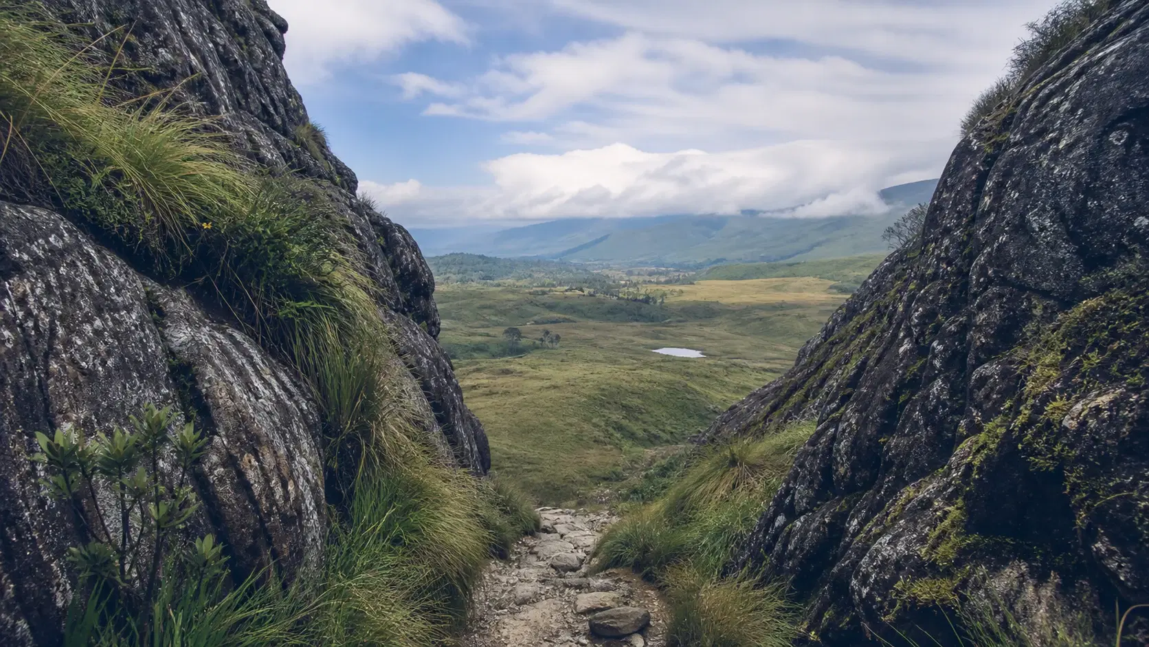
You climb a narrow zigzag path through a V-shaped gap in the rock, a feature known locally as Jacob's Ladder. Behind you is the Bogawantalawa valley: tea bushes to the horizon, factories, line rooms, the whole familiar apparatus of the hill country.

Then you step through the gap and the tea is gone. In front of you is open grassland, rolling and empty, running toward distant hills. Somewhere below, thousands of cattle are grazing on cultivated pasture at over fifteen hundred metres.

This is Bopaththalawa, and it does not look like anywhere else on the Pekoe Trail. The trail organisation's own description says crossing through the gap feels like stepping into a new world, and for once the language is proportionate.

Stage 9 is graded Hard in both directions. It is the only stage in the first ten that carries that grading, above the Difficult of stages 2, 3, 4 and 10. It is also the highest the trail has climbed so far, topping out at around 1,647 m.

And here is the part that makes it unusual: despite being the hardest-graded stage in the cluster, it currently carries no landslide precaution. Stages 7 and 8, both graded Moderate, do. Stage 9 shows as open with only the standard wet-weather advisory.

That combination, hard walking with a clean current status, makes this a genuinely appealing proposition for experienced hikers right now. This guide covers the route, the pass, the dairy valley, the camping options and an honest assessment of who should be attempting it.

Quick Summary

  • Stage 9 runs 17.13 km according to the trail information box, though the route description gives 16.4 km
  • It gains 738 m and loses 610 m to a maximum of around 1,647 m, the highest point of the trail so far
  • It is graded Hard in both directions, the only Hard stage in the first ten
  • People interaction is rated Low; this is remote walking for much of the day
  • It currently shows as open with only a standard wet-weather advisory and no landslide precaution
  • Jacob's Ladder, a V-shaped rock pass at around 3 km, separates tea country from highland grassland
  • The Bopaththalawa valley beyond the pass contains large dairy farms grazing thousands of cattle at around 1,584 m
  • The stage page lists the region as Ohiya while the index groups it under Hatton

The Numbers, and a Length That Does Not Match

The trail information box gives Stage 9 as 17.13 km with 738 m of elevation gain, 610 m of loss, a maximum elevation of around 1,647 m, an average duration of 5 hours, people interactions rated Low, region Ohiya, and a grading of Hard in both directions.

The route description on the same page concludes by saying the stage covers a distance of 16.4 km. That is a gap of over seven hundred metres between two figures on the same page.

This is now the third stage in the Hatton cluster where the official numbers do not reconcile internally. Stage 6 gives three different lengths across its own materials, and Stage 4 in the previous cluster has a duration figure that cannot be squared with its elevation profile.

None of these are serious individually. Cumulatively they are a good reason to treat published Pekoe Trail figures as approximations and to plan with margin rather than to the minute.

There is also a regional classification issue. The stage page lists the region as Ohiya. The stage index groups Stage 9 under the Hatton area with stages 6 to 10. Geographically the stage does move toward the Ohiya and Horton Plains side of the highlands, so the stage page arguably has the better claim.

This is the third such inconsistency we have found: Stage 5 is Hatton on its page and Kandy on the index, Stage 9 is Ohiya on its page and Hatton on the index, and Stage 10 is Haputale on its page and Hatton on the index. The index's five-stage Hatton cluster contains stages the organisation itself assigns to three different regions.

On duration: the official 5 hours is a fit hiker's moving time and it is optimistic for a Hard-graded stage of over 16 km with 738 m of climbing. We suggest planning 7 to 9 hours elapsed.

The profile is front-loaded like Stage 8 but harder. The climb to Jacob's Ladder starts almost immediately and the pass sits at around 3 km. After that the valley walking is comparatively gentle, with a further ascent through forest between roughly 12 km and 14 km, then a descent to Dayagama.

17.13 km in the information box, 16.4 km in the route description738 m gain, 610 m loss, maximum around 1,647 mGraded Hard, the only one in the first ten stagesRegion given as Ohiya on the page, Hatton on the indexOfficial 5 hours; plan 7 to 9 hours elapsed

Why This Stage Is Graded Hard

Stage 9 is not the longest stage in the cluster. That is Stage 7 at 16.48 km, or Stage 9 itself depending on which of its two published lengths you accept. It does not have the most climbing either. That is Stage 10 at 983 m within this cluster, and Stage 4 at 1,195 m in the previous one.

So why is this the one graded Hard when those are graded Moderate and Difficult?

Our reading is that the grading reflects a combination of factors rather than any single number, and understanding them tells you what kind of day to prepare for.

The first is the pass itself. Jacob's Ladder is a narrow zigzag path climbing through a rock gap. The official description says it is relatively straightforward in dry conditions but can be slippery during rain, and advises stepping carefully. That is the only place in the first ten stages where the trail asks you to negotiate genuine rock terrain rather than a walking surface.

The second is remoteness. People interaction is rated Low, and beyond the pass you are in a valley with two dairy farms, a school, a scattering of houses and very little else. There is one listed emergency point for the entire stage: Dayagama Police Station.

The third is elevation. At around 1,647 m this is the highest the trail has been, and while that is not altitude in any medical sense, it does mean cold, exposure and weather that changes fast.

The fourth is exposure. The grassland sections beyond the pass have no shelter and no shade. In sun that is a heat problem; in mist and wind it is a navigation and comfort problem.

The fifth is that this is genuinely a full day. Even at the optimistic official duration of 5 hours, adding stops puts you well into the afternoon, and the terrain does not let you make up time.

None of this makes Stage 9 dangerous. It makes it a stage for people who have done long hill days before and know how they respond to them.

Jacob's Ladder is the only real rock terrain in the first ten stagesLow people interaction and one listed emergency pointHighest elevation on the trail so far at around 1,647 mGrassland sections offer no shade or shelterA genuine full day even at the optimistic official duration

The Route: Bogawantalawa to Jacob's Ladder

The stage begins in Bogawantalawa town, which sits at an elevation of 1,279 m and lends its name to the valley around it. The trail organisation notes that the region is home to some of Sri Lanka's most legendary tea estates, including Norwood, Kotiyagala, Tientsin, Kew and Loinorn, the last of which sits between the Peak Wilderness and Horton Plains National Park.

Leaving town, the trail heads northwest toward the Bogawana Tea Factory, which is visible ahead and comes into view at around the 900 metre mark, passed on the left. It is a colonial-era factory dating to 1891.

Shortly after the factory the road forks into three paths. Take the middle track, which curves around the hillside toward the Lynstead division. This is a genuine navigation decision point and worth having the app open for.

From here Jacob's Ladder becomes visible ahead: a rocky, V-shaped gap in the mountain ridge. Seeing your objective from several kilometres out is unusual on this trail and it does something for the walking.

At around 3 km you pass the Lynstead superintendent's bungalow and arrive at the base of the pass. A narrow, well-marked path zigzags upward through the gap.

The climb is described as relatively straightforward in dry conditions but slippery during rain. Step carefully. This is the section that most justifies the Hard grading and the one place on this stage where wet weather materially changes the difficulty.

As you climb, Bogawantalawa town and the upper divisions of the Kotiyagala Estate stretch out behind you. Turning around is worth doing repeatedly on this ascent.

Then you cross through the gap, and the landscape changes completely.

Bogawantalawa town sits at 1,279 mBogawana Tea Factory dates to 1891, passed at around 900 mTake the middle track at the three-way forkJacob's Ladder is visible from several kilometres outThe pass climb is slippery in rain and justifies the Hard grade

Bopaththalawa: The Hidden Valley of Cattle and Grassland

Beyond the pass the bustling tea plantations give way to serene grasslands and rolling hills, and the only visible path leads forward into the secluded valley of Bopaththalawa, sitting at an elevation of around 1,584 m.

This is the single most unexpected landscape on the first ten stages of the Pekoe Trail. Highland grassland at this elevation in Sri Lanka is comparatively rare, and finding it immediately behind a rock gap after ten kilometres of tea bushes is genuinely disorienting in the best way.

What makes it stranger is the cattle. Bopaththalawa contains two large dairy farms. About a kilometre past the pass you reach Manik Palama Farm, the first of them, where the track becomes a country road winding through cultivated grass fields feeding the farm's thousands of cows.

Dairy farming at this scale and elevation is not what most visitors associate with Sri Lanka, and it exists here for the same reason the tea does: the cool, temperate highland climate suits temperate agriculture in a way the lowlands do not. Sri Lanka's highland dairy sector is genuinely significant and largely invisible to tourism.

At around 7.3 km you pass a cluster of houses and continue northeast, with forest beginning to line the right side of the path. At around 9 km you pass a circuit bungalow on the left.

The route shifts eastward at around 10.4 km toward Bopaththalawa Farm, the valley's namesake dairy operation. At around 11.4 km you pass its cowsheds and a few homes with vibrant vegetable gardens before entering forest.

There is a school in the valley, Bopaththalawa Sinhala Vidyalaya, listed among the stage's points of interest. Its presence tells you this is a working community rather than an empty landscape, and it should shape how you behave passing through.

Practical note on the farms: these are agricultural businesses. Do not enter fields, do not approach or attempt to handle cattle, and close any gate you open. Livestock disease control is taken seriously in dairy operations and casual visitor traffic through pasture is not welcome.

Grassland and rolling hills at around 1,584 mTwo large dairy farms grazing thousands of cattleManik Palama Farm at around 4 km, Bopaththalawa Farm from 10.4 kmHighland dairy suits the cool climate, like the teaA working community with its own school, not an empty valley

The Route: Eucalyptus Forest and the Descent to Dayagama

After the cowsheds at around 11.4 km the trail enters forest, and the next two kilometres are a gentle ascent along a forest path shaded primarily by eucalyptus.

Those eucalyptus trees are not native and they are not accidental. They were planted to supply firewood for tea factories, which need substantial fuel to power the withering and drying process. Plantation forestry of this kind is a standard feature of the Sri Lankan highlands and it is one of the less visible ways the tea industry reshaped this landscape.

The official guidance for this section is worth following precisely: in areas like this it is wise to make noise, and clapping, singing or talking loudly helps avoid startling wildlife. Stay on the trail to minimise environmental impact.

That advice is about avoiding surprise encounters rather than about danger. Most highland wildlife will move away from an approaching human it has heard coming. The problem arises when a quiet walker rounds a bend and meets an animal at close range, which is bad for both parties.

This valley sits within reach of Peak Wilderness and Horton Plains, and the surrounding landscape supports sambar, wild boar, various endemic birds and, in the wider region, leopard. Encounters on the trail are unlikely but not impossible.

At around 14 km the forest trail opens into a small village, marking your entrance into the Agarapatana Valley. The trail organisation describes this as a remote and less-travelled area of the tea country with a genuine sense of isolation.

Turn left, heading north, and follow the descending road to Dayagama town.

The stage concludes in Dayagama, at an elevation of around 1,417 m. Note that Stage 10's page gives Dayagama as 1,421 m, a four-metre difference between two official pages that we mention only because it is characteristic of the precision available on this trail.

Eucalyptus planted to fuel tea factory drying processesMake noise through the forest to avoid startling wildlifeStay on the trail to minimise impactAgarapatana Valley village at around 14 kmFinishes in Dayagama at around 1,417 m

Camping in the Valley: What the Official Guidance Says

Stage 9 is the only stage in the first ten where the trail organisation's own route description mentions camping as an option, which makes it worth treating carefully rather than as an aside.

On the foothills of Haritha Mountain, to the west of the trail after the pass, there are two unmarked camping sites. The official guidance is explicit: should you choose to camp here, ensure you leave no trace and preserve this pristine area by cleaning up thoroughly.

A separate campsite, described as the Haritha Kanda famous campsite, appears among the stage's listed points of interest, along with the Bopaththalawa camp site.

The word unmarked is doing important work in that guidance. These are not managed campgrounds with facilities, permits and wardens. They are places where camping happens.

That has several implications. There are no toilets, so you need to know how to deal with waste properly in a catchment area, which means carrying it out rather than burying it. There is no water supply you should assume is safe without treatment. There is no shelter, no phone signal and no help.

There is also a permissions question. Land in this valley belongs to somebody, whether farms, the state, or forestry, and your Pekoe Trail pass covers walking the route rather than camping on the land beside it. If you intend to camp, ask locally about permission rather than assuming.

Weather is the practical constraint. At around 1,584 m in an exposed grassland valley, nights are genuinely cold by Sri Lankan standards and can drop close to single digits Celsius. Visitors who pack for a tropical country and then camp at this elevation have a bad night. Bring a proper sleeping bag rated for cold, not a liner.

If you do camp, the payoff is real: a night in an open highland valley with dark skies, well away from any settlement, is not an experience Sri Lanka offers in many places.

For most walkers, though, we would suggest splitting the stage differently or simply taking the long day. Camping here is for people with the right equipment and the right ethics, and the trail organisation's leave-no-trace instruction should be read as a condition rather than a suggestion.

Two unmarked camping sites on the Haritha Mountain foothillsUnmarked means no facilities, water, shelter or helpCarry out all waste; this is a catchment areaAsk locally about permission; the trail pass covers walking, not campingNights at 1,584 m are genuinely cold; pack accordingly

Current Safety Position

At the time of writing Stage 9 shows as open with a standard advisory: expect wet and slippery sections after recent rainfall, exercise normal caution and monitor weather updates.

There is no landslide precaution on this stage. That puts it alongside stages 5 and 6 as one of the currently unflagged stages, and it is the only Hard or Difficult stage in the first ten with a clean status.

That is a genuinely useful piece of information for an experienced hiker planning a trip. Stages 2, 3, 4, 7 and 8 all carry additional warnings. Stage 9 does not, despite being the hardest-graded of the lot.

We would not read that as meaning Stage 9 is easy or risk-free. The Hard grading exists for reasons set out above, and the standard advisory about wet and slippery sections applies with particular force to Jacob's Ladder, where the official description specifically warns about slipperiness in rain.

Nor should it be read as permanent. Trail statuses on this route move with the weather, and a period of persistent rain could put a precaution on this stage as easily as on any other. Check the official stage page and TrailWatch before you walk.

The single listed emergency point is Dayagama Police Station. Save that number offline, along with your accommodation and driver.

Mobile signal is rated poor, which on a Low people-interaction stage with one emergency point is worth taking seriously. Tell someone your route, start time and expected finish before you set out.

We would not walk this stage alone. There is no official instruction against it here, unlike stages 2 to 4, but the combination of Hard grading, rock pass, remoteness and single emergency contact makes solo walking a poor idea regardless of what the advisory says.

Currently open with only a standard wet-weather advisoryThe only Hard or Difficult stage in the first ten with a clean statusJacob's Ladder is specifically slippery in rainOne listed emergency point: Dayagama Police StationWe would not walk this stage alone despite no official instruction

Transport at Both Ends

Bogawantalawa, the start, is a working tea town at the heart of the Golden Valley, and it is where Stage 8 finishes. If you are walking sequentially you are already there, which removes a transfer entirely.

Dayagama, the finish, is a different proposition. The trail organisation describes it as one of the most remote villages in the tea country, at the far end of the Agarapatana Valley, and notes that very few travellers venture this far.

It is reached by road, but it is not on a major through route in the way Norwood or Talawakele are. Arranging a pickup there requires a driver who is willing to make the journey and knows where they are going.

Discuss this explicitly when booking. Give the driver the map pin rather than the name, agree a specific meeting point in the village, and give a generous time window based on our 7 to 9 hour estimate rather than the official 5 hours.

Signal along the route is poor, so confirm everything before you start walking.

If you are continuing to Stage 10, Dayagama is where that stage begins, which makes staying overnight there the logical choice despite the limited options. Stage 10 has an entry cutoff that makes an early start essential, so being in the village the night before is close to necessary rather than merely convenient.

Accommodation in Dayagama is limited. There are options in the wider Agarapatana area and a partner property or two listed in the trail organisation's accommodation directory, but this is not a place to arrive without a booking.

For the wider 2026 picture, this whole region is reached by road while the Rambukkana to Nanu Oya section of the Main Line remains closed for repairs following Cyclone Ditwah, with reopening expected around January 2027. Transfers across the hill country are slower than published itineraries assume.

Bogawantalawa start is where Stage 8 finishesDayagama is described as one of the most remote tea country villagesGive your driver a map pin, not just a place nameStaying in Dayagama is near-essential if you are walking Stage 10 nextAccommodation is limited; book rather than arrive hopeful

When to Walk Stage 9

January to April is our recommendation and here it matters more than usual, for two specific reasons.

The first is Jacob's Ladder. The official description says the climb is relatively straightforward in dry conditions but can be slippery during rain. A rock pass in the wet is a different proposition from the same pass in the dry, and this is the crux of the stage.

The second is the grassland. The Bopaththalawa valley is exposed, with no shade and no shelter. In clear dry weather that is glorious. In mist it is disorienting and the whole reason for crossing the pass disappears. In rain and wind at 1,584 m it is genuinely unpleasant.

The southwest monsoon, roughly May to September, brings the wetter weather to this side of the highlands. We would avoid this stage during it, not because of a landslide precaution, which currently does not exist here, but because the two defining features of the stage both need dry conditions to work.

Time of day: start early. Our 7 to 9 hour estimate on a Hard stage means a 7:00 am departure at the latest, and earlier is better. Highland mist builds through the afternoon and you want the valley crossing done in clear air.

There is a further argument for an early start specific to this stage. If you are continuing to Stage 10 the following day, that stage has an entry cutoff that requires a very early start, so arriving in Dayagama tired at dusk is a poor setup for it.

Temperature is worth planning for. At around 1,647 m, mornings are cold by Sri Lankan standards and the grassland has no shelter from wind. Carry a layer you can put on at the pass, even if you will not want it by mid-morning.

Build flexibility in. This is a stage where the difference between a dry day and a wet one is the difference between one of the best walks in the cluster and a slog through mist over slippery rock.

January to April; the pass and the grassland both need dry weatherJacob's Ladder is specifically slippery in rainMist removes the entire point of crossing the passStart by 7:00 am at the latest on a Hard stageCarry a warm layer for the pass and the exposed valley

Preparation and What to Carry

Stage 9 is the stage in this cluster where getting your kit wrong has the most consequences, because of the remoteness and the exposure.

Water first: carry at least three litres per person. Beyond the pass there is no reliable resupply. There are streams in the valley but this is dairy farming country and grazing land, so treat anything you take from them rather than drinking it directly.

Food for the whole day plus a margin. Nothing between Bogawantalawa and Dayagama can be relied on to be open.

Footwear matters more here than on any other stage in the cluster. Jacob's Ladder is rock and it is slippery when wet. Trail shoes or light boots with genuine grip, not worn trainers.

Warm layers. At around 1,647 m in exposed grassland, wind chill is real. Carry a warm layer and a windproof shell even on a day that starts warm in Bogawantalawa.

Full sun protection for the grassland, which has no shade at all. Hat, sunscreen, sunglasses, and a light long-sleeved layer that doubles as sun and wind protection.

Walking poles are genuinely useful here, both on the pass ascent and on the descent to Dayagama.

Navigation: download the stage route and offline maps. The three-way fork after the tea factory is a real decision point, and the grassland sections offer few landmarks in mist.

Leech socks if there has been rain, mainly for the eucalyptus forest section.

Then the standard set: first aid kit, power bank, headtorch given the length of the day, the Dayagama Police Station number saved offline, cash for Dayagama, and your trail pass loaded in the app before you leave signal.

If you intend to camp, add a cold-rated sleeping bag, a means of treating water, and a plan for carrying out all waste.

At least three litres of water; treat any stream waterGrip is critical on Jacob's LadderWarm layer and windproof for the exposed grasslandFull sun protection; the valley has no shadeDownload the route; the fork after the factory is a real decision point

Walking Stage 9 Responsibly

With a Low people-interaction rating, much of what you do on this stage is unobserved, which makes it a test of whether your trail ethics are habits or performance.

Carry out everything. There are no bins, no collection and nobody following you. The trail organisation asks hikers to pick up litter they find as well, and on a stage this quiet that is easy.

The dairy farms are agricultural businesses, not scenery. Do not enter fields or pasture, do not approach or attempt to handle cattle, close any gate you open, and stay on the road or track through the farm sections. Livestock operations take biosecurity seriously.

The valley has a school and homes with vegetable gardens. This is a community. Greet people, ask before photographing anyone or their property, and do not photograph children.

In the eucalyptus forest, make moderate noise as the official guidance suggests, and stay on the trail to minimise environmental impact. Do not go looking for wildlife off the path.

Do not pick or collect plants. The grassland and the forest around Bopaththalawa sit close to protected areas and the highland grassland ecosystem is comparatively rare.

If you camp, leave no trace is a condition rather than an aspiration. Carry out all waste including human waste, do not cut vegetation, do not build fire rings, and leave the site indistinguishable from how you found it.

Do not swim in or contaminate water sources. This is a catchment feeding communities downstream and a working dairy area.

Buy locally where you can. Bogawantalawa at the start and Dayagama at the finish are both places where a meal or a purchase means something, and Dayagama in particular sees very few visitors.

Drones need landowner permission and should not be flown over farms, homes or the school.

Carry out everything; this stage is largely unobservedDo not enter pasture or approach cattle; close gatesThe valley has a school and homes; ask before photographingMake moderate noise in the forest and stay on the trailLeave no trace is a condition of camping, not a suggestion

Should You Walk Stage 9? An Honest Verdict

Stage 9 is the best walk in the Hatton cluster and the one fewest people should attempt. Both of those are true.

Walk Stage 9 if you are an experienced hiker, comfortable with a Hard-graded 17 km day, walking with at least one other person, and able to start early with the right kit. For that person this is outstanding: a genuine mountain pass, a landscape that appears nowhere else on the trail, and real remoteness.

Walk it if the Kandy cluster's landslide precautions have limited your options. Right now this is the only Hard or Difficult stage in the first ten with a clean status, which for an experienced hiker in 2026 is a meaningful window.

Walk it if you have found stages 7 and 8 comfortable and want the step up. It chains neatly from Bogawantalawa where Stage 8 finishes.

Do not walk it in wet weather. Jacob's Ladder is slippery in rain and the grassland in mist gives you none of the reward for the effort.

Do not walk it alone. There is no official instruction against it, but a Hard rock pass, Low people interaction, poor signal and one emergency contact is not a solo proposition.

Do not walk it as a step up from nothing. If Stage 1 or Stage 6 was your longest recent walk, this is not the next one. Stage 8 or Stage 7 is a better intermediate step.

Do not bring children. The grading, the rock section and the remoteness rule it out.

Do not camp unless you have proper cold-weather equipment and a genuine leave-no-trace practice. An exposed valley at 1,584 m is unforgiving of optimistic packing.

And do not attempt this and Stage 10 as consecutive days casually. Stage 10 has an entry cutoff, a park fee and 983 m of climbing to 2,138 m. Doing a Hard stage the day before means arriving at that already tired.

For the hiker it suits, though, stepping through Jacob's Ladder into an empty grassland valley is the moment the Pekoe Trail stops being a tea walk and becomes a mountain route. It is worth the effort of getting there.

The best walk in the cluster and the least suitable for most peopleCurrently the only clean-status Hard or Difficult stage in the first tenDo not walk it wet, alone, or as a step up from nothingCamping needs proper cold-weather kit and real leave-no-trace practiceThink carefully before chaining it directly into Stage 10

Travel Tips

  • Plan 7 to 9 hours elapsed rather than the official 5 hours; this is a Hard-graded stage
  • Do not attempt Jacob's Ladder in wet conditions; the rock is specifically noted as slippery in rain
  • Do not hike this stage alone despite the absence of an official instruction against it
  • Carry at least three litres of water and treat any stream water; this is grazing country
  • Carry a warm layer and windproof for the exposed grassland at around 1,647 m
  • Take the middle track at the three-way fork after the Bogawana Tea Factory
  • Make moderate noise through the eucalyptus forest to avoid startling wildlife
  • Do not enter pasture or approach cattle, and close any gate you open
  • Give your driver a map pin for Dayagama, not just the village name
  • Book accommodation in Dayagama in advance; options are very limited
  • Save the Dayagama Police Station number offline before you start
  • If camping, bring a cold-rated sleeping bag and carry out all waste including human waste
  • Ask locally about permission before camping; the trail pass covers walking, not camping
  • Start early if you plan to walk Stage 10 the following day; it has an entry cutoff
  • Download the stage route; the grassland has few landmarks in mist

Frequently Asked Questions

How long is Pekoe Trail Stage 9?

The trail information box gives 17.13 km while the route description on the same page concludes with 16.4 km. It gains 738 m and loses 610 m to a maximum of around 1,647 m. Treat the length as approximately 17 km and plan with margin.

Why is Stage 9 graded Hard?

It is not the longest or highest-climbing stage in the cluster. The Hard grading appears to reflect a combination: the rock terrain at Jacob's Ladder, the Low people-interaction rating, the highest elevation on the trail so far at around 1,647 m, exposed grassland with no shade or shelter, and the length of the day.

What is Jacob's Ladder?

A rocky, V-shaped mountain pass at around the 3 km mark, climbed by a narrow zigzag path. It separates the tea country of the Bogawantalawa valley from the grasslands of Bopaththalawa beyond. The official description says it is relatively straightforward in dry conditions but can be slippery in rain.

What is Bopaththalawa like?

A secluded highland valley at around 1,584 m of open grassland and rolling hills, containing two large dairy farms grazing thousands of cattle. It looks nothing like the tea country on the other side of the pass and it is the most unexpected landscape in the first ten stages.

Is Stage 9 safe to hike right now?

At the time of writing it shows as open with only a standard advisory about wet and slippery sections after rainfall, and no landslide precaution. It is currently the only Hard or Difficult stage in the first ten with a clean status. Statuses change, so check the stage page and TrailWatch before you go.

Can I hike Stage 9 alone?

There is no official instruction against it on this stage, unlike stages 2 to 4. We would still not recommend it. The Hard grading, the rock pass, the Low people-interaction rating, poor mobile signal and a single listed emergency point together make a poor case for solo walking.

Can I camp on Stage 9?

The official route description mentions two unmarked camping sites on the foothills of Haritha Mountain, with explicit instruction to leave no trace and clean up thoroughly. Unmarked means no facilities, water or help. Ask locally about permission, since the trail pass covers walking rather than camping, and bring cold-rated equipment for a night at around 1,584 m.

Why are there dairy farms in the Sri Lankan highlands?

For the same reason there is tea: the cool temperate highland climate suits temperate agriculture in a way the lowlands do not. Sri Lanka's highland dairy sector is genuinely significant and almost entirely invisible to tourism. Bopaththalawa contains two large farms grazing thousands of cattle.

Why should I make noise in the forest section?

The official guidance recommends clapping, singing or talking loudly through the eucalyptus forest to avoid startling wildlife. This is about preventing surprise encounters rather than danger. Animals that hear you coming move away; the problem is a quiet walker meeting an animal at close range around a bend.

Which region is Stage 9 in?

The stage page lists the region as Ohiya, while the stage index groups it under the Hatton area with stages 6 to 10. Geographically the stage moves toward the Ohiya and Horton Plains side of the highlands, so the stage page arguably has the better claim. This is the third such inconsistency in the cluster.

How do I get to and from Stage 9?

Bogawantalawa at the start is a working tea town where Stage 8 finishes. Dayagama at the finish is described as one of the most remote villages in the tea country and is not on a major through route. Give your driver a map pin rather than just the name, and a generous time window.

What is the Bogawana Tea Factory?

A colonial-era tea factory dating to 1891, passed on the left at around the 900 metre mark shortly after leaving Bogawantalawa town. It is a prominent landmark and useful for navigation, since the three-way fork where you take the middle track comes just after it.

Do I need a trail pass for Stage 9?

Yes. Foreign visitors pay USD 10 per stage, Sri Lankan residents pay LKR 600, and children under 12 are free. Buy it through the official app or web portal before you leave signal, since coverage on this stage is poor.

Should I walk Stage 9 and Stage 10 on consecutive days?

Think carefully. Stage 10 climbs 983 m to 2,138 m, requires a Horton Plains National Park ticket, and has an entry cutoff that means starting very early. Arriving in Dayagama tired after a Hard-graded stage is a poor setup for that. A rest day between them is worth considering.

Is Stage 9 suitable for families or beginners?

No. It is graded Hard, involves a rock pass that is slippery when wet, is remote with a single emergency contact, and is a full day. Stage 1 remains the strongest family stage on the trail, and Stage 6 is a better step up for developing hikers.

Reader notes

Join the conversation

Share your question, tip, or travel experience for this guide.

Comments

0 comments

Loading...

Ready to turn inspiration into a Sri Lanka trip?

Use LankaTrip to plan your journey, connect with local guides, and make this itinerary a reality.

Need help planning?

Plan your Sri Lanka adventure

Plan my trip